Key takeaways
- ✓The overlay that regulates you is the one in your council's planning scheme, not the state mapping underneath it.
- ✓Start with Queensland Globe to confirm the correct lot on plan, then go to your council's interactive scheme mapping.
- ✓Most councils will generate a free property or parcel report listing the zone and every overlay affecting the land.
- ✓A planning and development certificate is the formal option, created by section 265 of the Planning Act 2016, in limited, standard and full versions.
- ✓An overlay can affect only part of a lot, so check whether your building envelope is actually inside the mapped area.
How to Check Which Overlays Apply to Your Property in QLD
You'll usually hear council approval called a development application, or DA — that's the formal name for it under the Planning Act 2016. Whether you need one, and how hard it will be, depends heavily on two things: your zone, and your overlays.
The zone tells you what the land is meant to be used for. An overlay identifies something about the land that has to be managed — flooding, bushfire, heritage character, habitat, noise, steep slope, an airport flight path. Overlays sit above zones in the assessment hierarchy, so an overlay can raise the category of assessment that the zone would otherwise have given you.
Get a council-ready planning report in 5 minutes — no planner, no waiting.
Get your report →The short answer
Start with Queensland Globe to confirm the correct lot on plan. Then use your council's interactive planning scheme mapping and generate a property or parcel report, which lists the zone and every overlay affecting the land. For a formal, council-issued record, order a planning and development certificate.
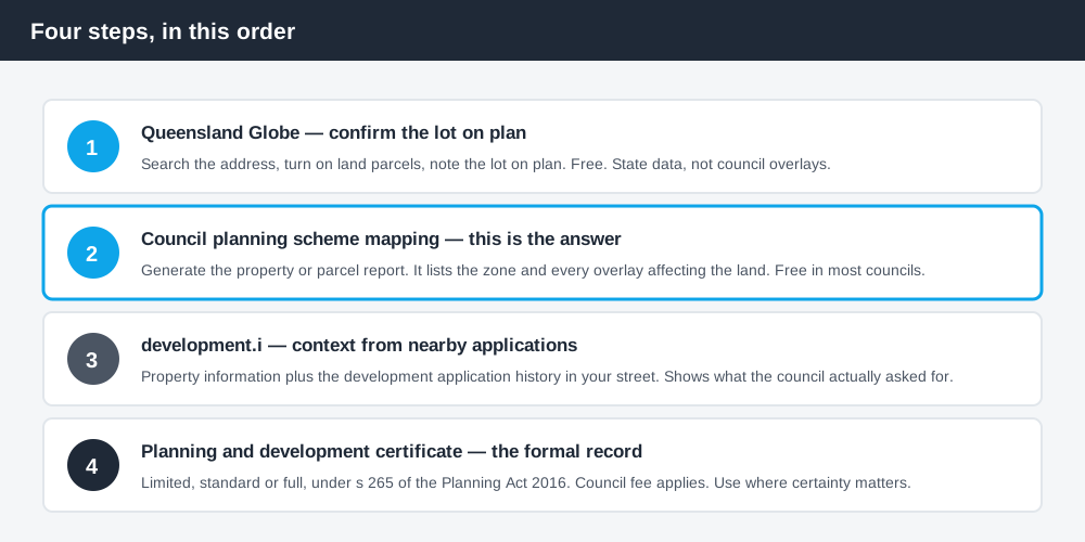
Figure 1: The order worth doing them in.
Step 1 — confirm the lot on plan in Queensland Globe
Everything downstream depends on searching the right parcel, and street addresses are unreliable — especially on rural land, recently subdivided estates, or a house that sits across two lots.
Queensland Globe is the state's free mapping platform. Search your street address, then turn on the land parcel layer under planning cadastre so the boundaries and the lot on plan label appear. You can also search directly by lot and plan, entered without spaces and without the words "lot" or "plan" — for example, 12SP123456.
- ✓Search the street address
- ✓Turn on land parcels and parcel labels
- ✓Note the lot on plan exactly as shown
- ✓Check whether the holding is one lot or several
Globe is not where you find your overlays. It shows state datasets, not council planning schemes. What it gives you is the correct parcel identifier to use everywhere else, which is worth five minutes. If you want a fuller walkthrough of the tool, the Queensland Globe property check covers it in detail.
Step 2 — your council's planning scheme mapping
Spend 5 minutes, not 3 weeks
instantDA generates a council-ready planning report for Queensland development applications. No town planner. No waiting.
Get your report →This is the step that actually answers the question, because the overlay that regulates your land is the one in your council's planning scheme.
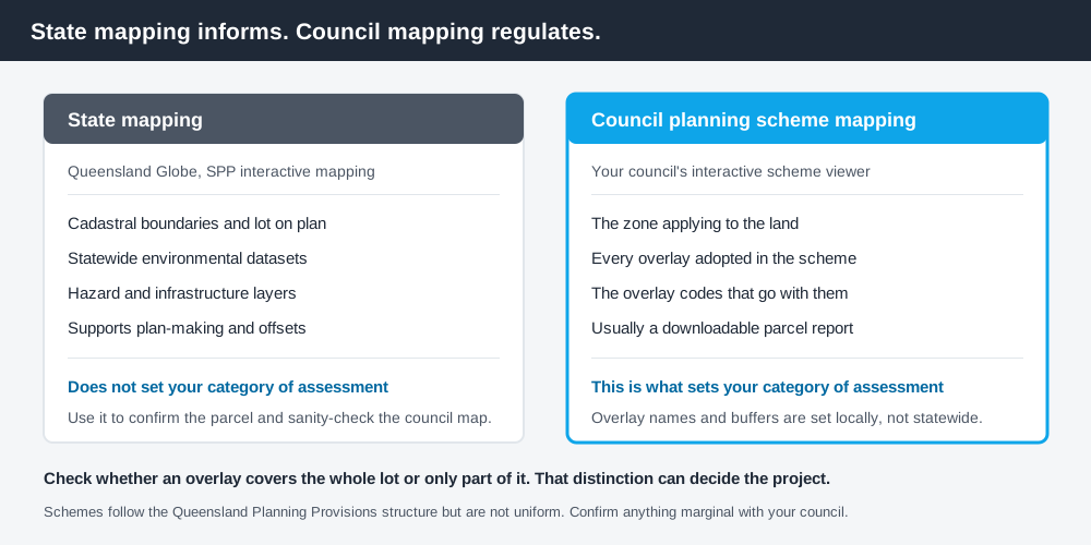
Figure 2: State mapping informs; council mapping regulates.
Nearly every Queensland council publishes interactive mapping where you search an address or lot on plan and toggle zoning and overlay layers. Most will also generate a downloadable report for the parcel. The names differ but the product is the same.
- ✓Brisbane — property information through development.i
- ✓Gold Coast — City Plan interactive mapping and a City Plan property report
- ✓Bundaberg — a planning scheme parcel report
- ✓Gladstone — a planning scheme report from the mapping tool
- ✓Douglas — an instant property report
Whatever it is called, read the report for two things: the zone, and the full list of overlays. Then note something the map alone will not tell you clearly — whether the overlay covers the whole lot or only part of it. A waterway corridor following a creek at the rear boundary, or a steep-land overlay on one corner, may leave your intended building envelope entirely unaffected. That distinction changes the project.
Step 3 — development.i for context
Development.i is the state-supported planning and development portal. It gives basic property information and, more usefully, the development applications lodged on a property and in the surrounding area.
That history is worth reading. If three neighbours in the same overlay have all been through a code assessable application for the same kind of work, you have a strong signal about what your council expects and what it asked them for. If an application in your street was refused, the decision notice tells you why. Neither is legal advice about your land, but both are better intelligence than guesswork.
Some councils use development.i as their main public interface; others run their own portal. Either way, application history is a free source of pattern evidence that most people never look at.
Step 4 — a planning and development certificate
When you need something formal — a contract, a due diligence file, a dispute, or simply certainty before spending real money — you can order a planning and development certificate from the council.
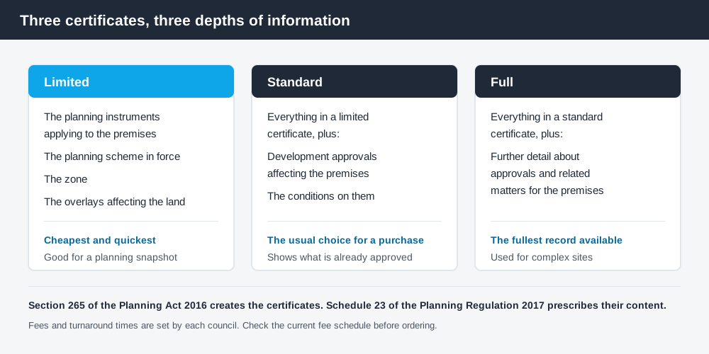
Figure 3: Three certificates, three depths of information.
This is a statutory product, not a courtesy. Section 265 of the Planning Act 2016, headed "Planning and development certificates", provides that a person may apply to a local government for a limited, standard or full planning and development certificate for premises. What each type must contain is prescribed by Schedule 23 of the Planning Regulation 2017, headed "Content of planning and development certificates", which sets out the requirements for limited, standard and full certificates in turn.
In broad terms, and subject to what Schedule 23 actually prescribes:
- ✓Limited — the planning instruments applying to the premises, including the scheme, zone and overlays
- ✓Standard — that information plus development approvals affecting the premises and their conditions
- ✓Full — the fullest record, including further detail about approvals and related matters
Councils charge a fee for each, and the fee and turnaround differ from council to council. For a homeowner adding a deck, a certificate is usually more than the question needs. For a purchase, a subdivision, or anything where you are relying on the planning position in a contract, it is the document that carries weight.
Reading what you find
Two habits save people from expensive misreadings.
Check for interactions. Overlays rarely arrive alone. Flood mapping travels with waterway mapping; bushfire mapping travels with vegetation controls; character overlays travel with demolition controls. Each brings its own code and its own category of assessment, and the highest one wins. If your report lists four overlays, read four codes. The flood hazard overlay in QLD and the biodiversity overlay in QLD are the two that most often change a straightforward project into an assessable one.
Do not assume uniformity. Queensland's planning schemes follow the Queensland Planning Provisions structure, but each council layers its own overlay names, mapping and codes on top. They are not uniform. An overlay called "environmental significance" in one council may have no equivalent in the next, and buffer distances are set locally rather than by the state. Advice you read about another council is a starting point, not an answer.
And if the zone itself is still unclear, work that out first — how to check zoning in QLD covers it, and the zone determines the baseline before any overlay adjusts it.
What to do next
Work through the four steps in order and write down, for your address: the lot on plan, the zone, every overlay, and whether each overlay touches your intended building envelope or only part of the lot. That single page is what a planner would want in front of them before saying anything useful.
If you'd rather have that set out for you than assemble it yourself, an instantDA planning report pulls your zone, your overlays and your likely category of assessment into one document for $169 — against the $800–$1,500 a town planner typically charges for a preliminary opinion. You can start a report in a few minutes.
Where anything is marginal — the mapping clips a corner, two overlays seem to conflict, the report is ambiguous — confirm it with your council before you commit. Council planning enquiry lines answer this kind of question routinely, and a note of the answer in your file is worth having.
Frequently asked questions
How do I find out what overlays apply to my property in Queensland?
What is the difference between a zone and an overlay?
Does Queensland Globe show planning scheme overlays?
What is a planning and development certificate?
Can an overlay apply to only part of my land?
Do all Queensland councils use the same overlay names?
Ready to generate your report?
Skip the writing. Get a council-ready planning report in 5 minutes.
Get your report