Key takeaways
- ✓Three separate layers can apply — state vegetation management, your council's planning scheme overlay, and council local laws.
- ✓Clearing native woody vegetation is regulated at state level under the Vegetation Management Act 1999.
- ✓The regulated vegetation management map is the state map that determines how vegetation on your land is categorised.
- ✓Accepted development vegetation clearing codes let some lower-impact clearing proceed without an approval, subject to conditions.
- ✓Protected plants under the Nature Conservation Act 1992 and koala habitat mapping in South East Queensland are separate frameworks again.
Vegetation Clearing and Biodiversity Overlays in QLD
Clearing vegetation in Queensland is one of the few areas of planning where checking only your council is genuinely dangerous. Three separate systems can apply to the same tree, run by two levels of government, and complying with one tells you nothing about the others.
That structure is the source of most of the trouble people get into. Someone checks the planning scheme, sees no restriction, clears, and discovers the state framework applied all along.
Get a council-ready planning report in 5 minutes — no planner, no waiting.
Get your report →The short answer
Three layers can apply. The Vegetation Management Act 1999 regulates clearing of native woody vegetation at state level, using the regulated vegetation management map. Your council's planning scheme may impose a biodiversity or vegetation overlay. And councils can separately protect trees through local laws.
Check all three. They operate together, and satisfying one is not a defence to breaching another.
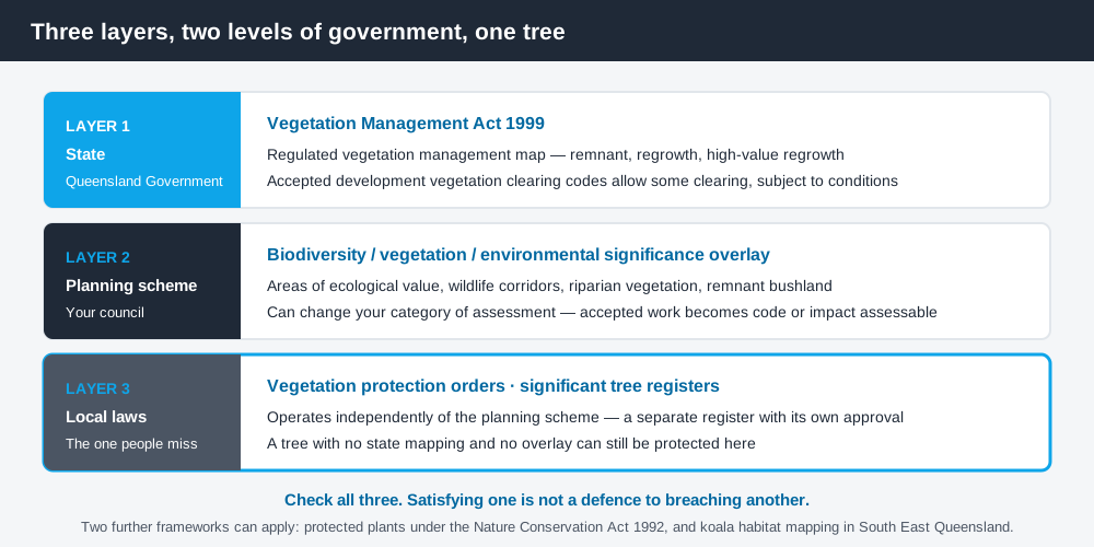
Figure 1: Three layers, two levels of government, one tree.
Layer one — the state framework
The Vegetation Management Act 1999 is Queensland's principal state Act regulating the clearing of native woody vegetation. Its purposes include conserving remnant vegetation, preventing land degradation, protecting biodiversity and maintaining ecological processes.
The instrument that determines how vegetation on your land is treated is the regulated vegetation management map — the state-certified map showing vegetation category areas. It identifies whether vegetation is remnant, regrowth, high-value regrowth or otherwise regulated, and that categorisation drives whether clearing is assessable, prohibited or accepted.
Accepted development vegetation clearing codes are state codes that allow certain lower-impact clearing without a development approval, provided the landholder complies with the conditions of the applicable code. Some pathways also require a notification.
You can request vegetation management mapping for your property from the Queensland Government, and doing that before you plan any clearing is far cheaper than doing it afterwards.
Layer two — the council overlay
Spend 5 minutes, not 3 weeks
instantDA generates a council-ready planning report for Queensland development applications. No town planner. No waiting.
Get your report →Your council's planning scheme may include a biodiversity, vegetation or environmental significance overlay, with an overlay code containing assessment benchmarks. These typically protect areas of ecological value, wildlife corridors, riparian vegetation and remnant bushland.
Queensland's planning schemes follow the Queensland Planning Provisions structure, but each council layers its own overlays and mapping on top. They are not uniform, and a council overlay can apply to vegetation the state framework does not regulate at all.
The overlay can also change your category of assessment. Work that would otherwise be accepted development can become code or impact assessable simply because it sits within a mapped biodiversity area.
Layer three — local laws
This is the layer people miss entirely. Councils in Queensland can protect vegetation through local laws rather than through the planning scheme — vegetation protection orders, significant tree registers, and general local law provisions requiring approval to damage or remove particular trees.
A local law operates independently of the planning scheme. A tree can be entirely unremarkable under the state mapping, absent from any overlay, and still be subject to a vegetation protection order that makes removing it an offence.
The practical step is simple: ask your council specifically about local law vegetation protection and any significant tree register, as a separate question from the planning scheme enquiry. Council approval for tree removal in QLD covers the residential tree removal case in more detail.
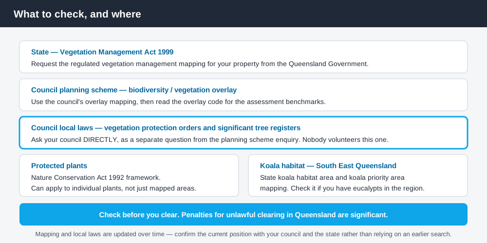
Figure 2: What to check, and where.
Two more frameworks
Protected plants. The Nature Conservation Act 1992 contains a separate protected plants framework, relevant where threatened or protected flora may be affected. It is distinct from the Vegetation Management Act framework and can apply to individual plants rather than mapped areas of vegetation.
Koala habitat. In South East Queensland, koala habitat is separately regulated through state mapping, including koala habitat areas and koala priority areas. If your property is in the region and carries eucalypt vegetation, check the koala mapping specifically — koala habitat in QLD covers what it means for development.
Where clearing questions usually arise
- ✓Clearing a building envelope on a bush block before construction
- ✓Removing trees for a driveway, effluent disposal area or firebreak
- ✓Subdividing land where vegetation sits across a proposed new lot
- ✓Bushfire mitigation clearing, which is not automatically permitted
- ✓Removing a single mature tree in an established suburb
Bushfire clearing is worth flagging. The desire to reduce fuel around a house is understandable and sometimes supported by the framework, but it is not a blanket authorisation to clear. Where a bushfire hazard overlay applies, work through the bushfire pathway rather than assuming clearing is permitted — building in a QLD bushfire hazard area sets out how that assessment runs.
The single-tree case in an established suburb is where local laws dominate. State mapping rarely captures a suburban street tree or garden specimen, but a local law or significant tree register very well might.
Why unlawful clearing is such an expensive mistake
Vegetation is the area of Queensland planning where the consequences of getting it wrong are least recoverable, and it is worth being blunt about why.
First, the evidence is permanent and public. Historical aerial imagery is readily available and regularly updated, so a comparison of before and after images establishes what was there and roughly when it went. Unlike most planning breaches, clearing cannot be quietly regularised later, because the thing that was removed cannot be put back.
Second, enforcement can come from more than one direction. A single clearing event can engage the state framework, the council's planning scheme and a council local law simultaneously, and each has its own enforcement pathway. A defence that the work complied with one of them does not answer the others.
Third, remediation orders are a real outcome. Where clearing is found to be unlawful, the response is not always a fine — it can be a requirement to revegetate to a specified standard and maintain the planting for a period, which is a long-tail obligation attached to the land.
What to do if you are unsure
The proportionate response is a written enquiry rather than a judgement call. Ask your council, in writing, whether the specific vegetation is subject to the planning scheme overlay or any local law, and request state vegetation mapping for the property at the same time. Both are inexpensive relative to the exposure, and a written answer is worth considerably more than a verbal one at the counter if a question arises later.
Where a project genuinely requires clearing, an ecological assessment prepared by a suitably qualified consultant is the usual supporting document, and it is far more persuasive lodged with the application than produced in response to an information request.
Check your own position
Work through all three layers in order. Request state vegetation management mapping for your property from the Queensland Government, check your council's planning scheme overlay mapping, then ask your council directly about local law vegetation protection and any significant tree register. General property and spatial information is on the Queensland Globe, and state vegetation mapping can be requested through the Queensland Government's vegetation map request service.
For the general process of identifying every overlay affecting a property, how to check overlays on a QLD property walks through it.
If you would rather see your zone, your overlays and your likely category of assessment in one document before you commit, an instantDA planning report does that for your address for $169 — against the $800–$1,500 a town planner typically charges for a preliminary opinion. You can start a report in a few minutes.
Because vegetation mapping and local laws are updated, and because penalties for unlawful clearing are significant, confirm the position with your council and the state before you clear anything.
Frequently asked questions
Can I clear vegetation on my own land in Queensland?
What is the regulated vegetation management map?
What are accepted development vegetation clearing codes?
Do council local laws protect trees separately from the planning scheme?
Are protected plants regulated separately in Queensland?
Can I clear vegetation for bushfire protection?
Ready to generate your report?
Skip the writing. Get a council-ready planning report in 5 minutes.
Get your report