Key takeaways
- ✓Bushfire operates on two tracks — a planning overlay assessed by council, and construction requirements assessed by your certifier.
- ✓The construction standard is AS 3959, Construction of buildings in bushfire-prone areas.
- ✓A Bushfire Attack Level, or BAL, is a site rating that determines which construction requirements apply — it is not the standard itself.
- ✓Queensland uses the State Planning Policy natural hazards framework and Bushfire resilient communities guidance, not any other state's bushfire document.
- ✓Being in the overlay does not stop you building. It changes what you build and how the application is assessed.
Building in a QLD Bushfire Hazard Area
A bushfire hazard overlay on a property report reads like a verdict. It is not one. Large parts of Queensland — including plenty of established suburbs on a vegetated ridge or backing onto a reserve — sit within one, and houses are approved and built in them constantly.
What the overlay does is change two things: how your application is assessed, and how the building has to be constructed. Both are manageable if you know about them before you design.
Get a council-ready planning report in 5 minutes — no planner, no waiting.
Get your report →The short answer
A bushfire hazard overlay triggers two separate things. Council assesses the proposal against the bushfire overlay code in its planning scheme, usually needing a bushfire hazard assessment. Separately, your building work must meet AS 3959, with the required construction level set by the site's Bushfire Attack Level, or BAL.
Keeping those two tracks apart saves a great deal of confusion, because different people decide each one.
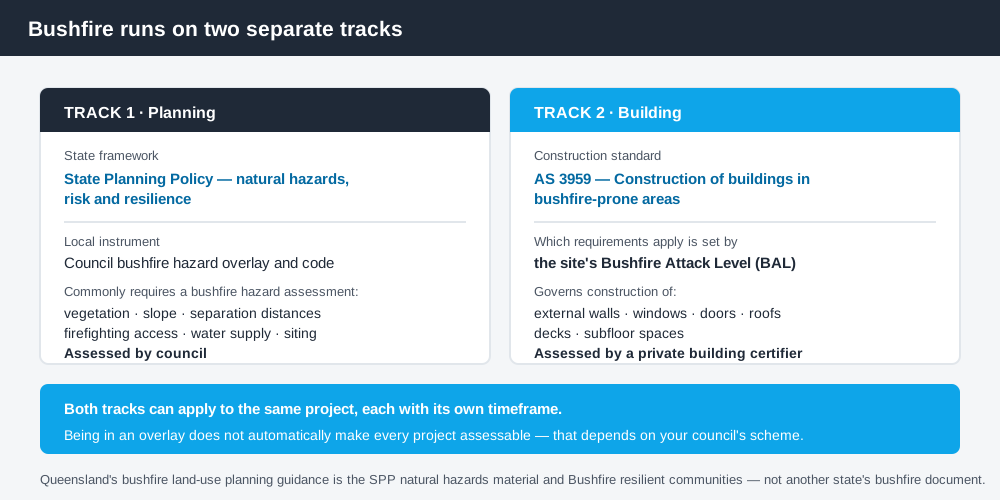
Figure 1: Two tracks, two decision-makers, one property.
Track one — the planning overlay
Queensland's State Planning Policy sets the state's interests in planning, including a natural hazards, risk and resilience interest that covers bushfire alongside flood, landslide, storm tide and erosion. It requires councils to identify hazard areas and assess risk so that development achieves an acceptable or tolerable level of risk to people and property.
Councils give that effect through a bushfire hazard overlay in the planning scheme, with a code containing the assessment benchmarks. Queensland's planning schemes follow the Queensland Planning Provisions structure, but each council layers its own codes and mapping on top. They are not uniform, so the overlay code in one council tells you little about the next.
For anything beyond a simple house — a subdivision, a new dwelling in a higher hazard classification, or a use with vulnerable occupants — councils commonly require a bushfire hazard assessment prepared by a suitably qualified practitioner. It typically addresses vegetation, slope, separation distances, access for firefighting vehicles, water supply for firefighting, and the siting of the building on the lot.
Queensland's own land-use planning guidance for bushfire sits in the State Planning Policy natural hazards material and in the Bushfire resilient communities guidance. If you are given advice referencing another state's bushfire planning document, it does not apply here.
Track two — the construction standard
Spend 5 minutes, not 3 weeks
instantDA generates a council-ready planning report for Queensland development applications. No town planner. No waiting.
Get your report →The construction standard is AS 3959, Construction of buildings in bushfire-prone areas. It sets out construction requirements for elements including external walls, windows, doors, roofs, decks and subfloor spaces.
Which set of requirements applies is determined by the Bushfire Attack Level, or BAL — a site-based rating of the building's likely exposure to ember attack, radiant heat and direct flame contact. The BAL is calculated from the vegetation classification around the site, the effective slope of the land under that vegetation, and the separation distance between the building and the vegetation.
That last input — separation distance — is why siting matters so much. Moving a building further from the hazardous vegetation, where the lot allows it, can lower the BAL and materially reduce construction cost. That is a design decision, made early, not something to discover at tender.
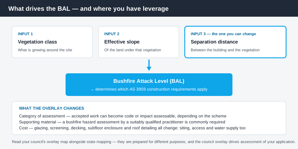
Figure 2: What drives the rating, and where the leverage is.
Who assesses which
Council assesses the planning side — the overlay code, the bushfire hazard assessment, siting, access and firefighting water supply. Whether that assessment is triggered at all depends on your council's scheme and what you are proposing; being in an overlay does not automatically make every project assessable.
Your private building certifier assesses the building side, applying the National Construction Code and AS 3959 at the relevant BAL. The Queensland Development Code, established by section 13 ("Queensland Development Code") of the Building Act 1975, handles the separate siting matters like setbacks and height.
In practice both tracks can apply to the same project, and each has its own timeframe. How to check overlays on a QLD property covers finding out which overlays apply before you commit to a design.
What the overlay actually changes
- ✓Category of assessment — the overlay can move work from accepted to code or impact assessable, depending on the scheme
- ✓Supporting material — a bushfire hazard assessment is commonly required
- ✓Construction cost — a higher BAL means more demanding materials and detailing
- ✓Siting and access — separation distances, driveway gradients and turning areas for firefighting vehicles
- ✓Water supply — a dedicated firefighting supply is often required on larger or rural lots
Cost is where this bites. The difference between a low BAL and a high one shows up in glazing, screening, decking material, subfloor enclosure and roof detailing, and it compounds across the whole building. On a rural or semi-rural block that difference is worth engineering around at concept stage — building on rural land in QLD covers the wider set of rural constraints.
Refusal on bushfire grounds alone is uncommon for a single dwelling on an existing lot. It is far more likely on a subdivision, where the question becomes whether new lots can be created at a tolerable risk level with adequate access and egress.
Access and water — the parts people forget
Two requirements consistently catch people on larger lots, and neither is about the house itself.
The first is access for firefighting vehicles. A long private driveway that suits a passenger car may not suit a fire appliance, which needs a workable gradient, adequate width, sufficient overhead clearance and somewhere to turn around at the end. Retrofitting a turning head or regrading a driveway after the design is settled is far more expensive than allowing for it at the outset.
The second is a dedicated water supply for firefighting, commonly required on larger or rural lots that are not connected to a reticulated supply with adequate pressure. That usually means a tank of a specified capacity with a fitting the local service can connect to, kept accessible and not plumbed into the house supply in a way that lets it be drained.
Both are cheap to design in and awkward to add later, which makes them worth raising with your designer at the same time as the BAL.
Checking your own land
You can check bushfire hazard mapping on your council's planning scheme mapping, which is the authoritative source for the overlay that applies to your land. State-level mapping is available through the Queensland Government's State Planning Policy pages, which provide access to the SPP interactive mapping system, and general property and spatial information is on the Queensland Globe.
Read the council overlay map alongside the state mapping. They are prepared for different purposes and do not always align, and it is the council's overlay that drives the assessment of your application.
Flood is the other hazard overlay that most commonly affects Queensland homeowners, and the two are assessed quite differently — building on flood-prone land in QLD covers that.
If you would rather see your zone, your overlays and your likely category of assessment in one document before you commission a design, an instantDA planning report does that for your address for $169 — against the $800–$1,500 a town planner typically charges for a preliminary opinion. You can start a report in a few minutes.
Then confirm the position with your council and your certifier before you build.
Frequently asked questions
Can I build in a bushfire hazard area in Queensland?
What is a BAL rating?
Which standard applies to building in a bushfire area in QLD?
Do I need a bushfire hazard assessment?
Can I reduce my BAL rating?
Does Queensland use the same bushfire planning document as other states?
Ready to generate your report?
Skip the writing. Get a council-ready planning report in 5 minutes.
Get your report