Key takeaways
- ✓Flood mapping in Queensland is a council planning scheme overlay, informed by the State Planning Policy natural hazards framework.
- ✓The defined flood event is the flood the controls are based on — commonly a 1% annual exceedance probability event.
- ✓The defined flood level is the level floodwater is expected to reach, and it usually drives your minimum floor level.
- ✓Freeboard is an added safety margin on top of the defined flood level, set by your council.
- ✓Being in a flood overlay changes how you build and can change your category of assessment — it rarely prohibits building outright.
Building on Flood-Prone Land in QLD
Flood is the constraint Queenslanders take most seriously, and rightly. It is also the one where the planning framework is most specific, most measurable and — once you understand three terms — most predictable.
The three terms are defined flood event, defined flood level and freeboard. Almost everything a council asks of you on flood-affected land follows from them.
Get a council-ready planning report in 5 minutes — no planner, no waiting.
Get your report →The short answer
Flood mapping in Queensland is a council planning scheme overlay, informed by the State Planning Policy natural hazards framework. The controls are based on a defined flood event, commonly a 1% annual exceedance probability flood. The defined flood level plus a council-set freeboard usually sets your minimum habitable floor level.
Notice that the state sets the framework and the council sets the numbers. That division explains why flood requirements differ so much from one council to the next.
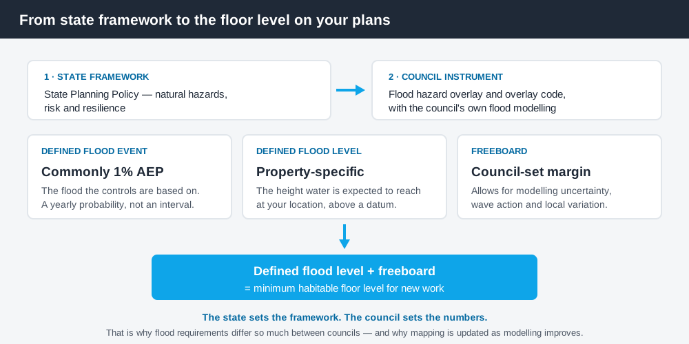
Figure 1: From state framework to the floor level on your plans.
The three terms
Defined flood event (DFE). The flood event the controls are based on. In Queensland planning schemes this is commonly the 1% annual exceedance probability flood — the flood with a one in a hundred chance of being equalled or exceeded in any given year. It is worth being precise about that: it is a yearly probability, not a promise about the next century, and two such floods can occur in consecutive years.
Defined flood level (DFL). The level floodwater is expected to reach at a particular location during the defined flood event, expressed as a height above a survey datum. This is a property-specific figure. It is the number that matters most to your design.
Freeboard. A safety margin added on top of the defined flood level, to allow for uncertainty in the modelling, wave action and local variation. Councils set their own freeboard, and it is applied to the DFL to produce a minimum habitable floor level.
Where the controls come from
Spend 5 minutes, not 3 weeks
instantDA generates a council-ready planning report for Queensland development applications. No town planner. No waiting.
Get your report →Queensland's State Planning Policy sets the state's interest in natural hazards, risk and resilience, covering flood alongside bushfire, landslide, storm tide and erosion. It requires councils to identify hazard areas and undertake a fit-for-purpose risk assessment so that development achieves an acceptable or tolerable level of risk.
Councils give that effect through a flood hazard overlay in the planning scheme, with an overlay code containing the assessment benchmarks. The same mapping often also serves a building-regulation function by designating the flood hazard area for building purposes, which is why flood turns up in both your planning assessment and your floor levels.
Queensland's planning schemes follow the Queensland Planning Provisions structure, but each council layers its own mapping, flood models and figures on top. They are not uniform, and flood mapping in particular is updated as new modelling becomes available.
What actually changes
- ✓Minimum habitable floor level — set from the defined flood level plus freeboard
- ✓Category of assessment — the overlay can move work from accepted to code or impact assessable, depending on the scheme
- ✓Building materials below the flood level — flood-resilient construction is commonly required
- ✓What can go underneath — habitable rooms below the flood level are usually restricted
- ✓Filling and earthworks — often controlled, because fill displaces floodwater onto neighbours
- ✓Storage of hazardous materials and, for some uses, evacuation planning
The floor level is the headline, but the restriction on what sits below it is what most often reshapes a design. A garage, laundry or storage area below the flood level may be acceptable where a bedroom or living room is not, and the distinction is usually drawn around habitable rooms.
Filling is the item people underestimate. Raising a site with fill sounds like a clean solution and is frequently controlled precisely because floodwater displaced from your land has to go somewhere — usually a neighbour's.
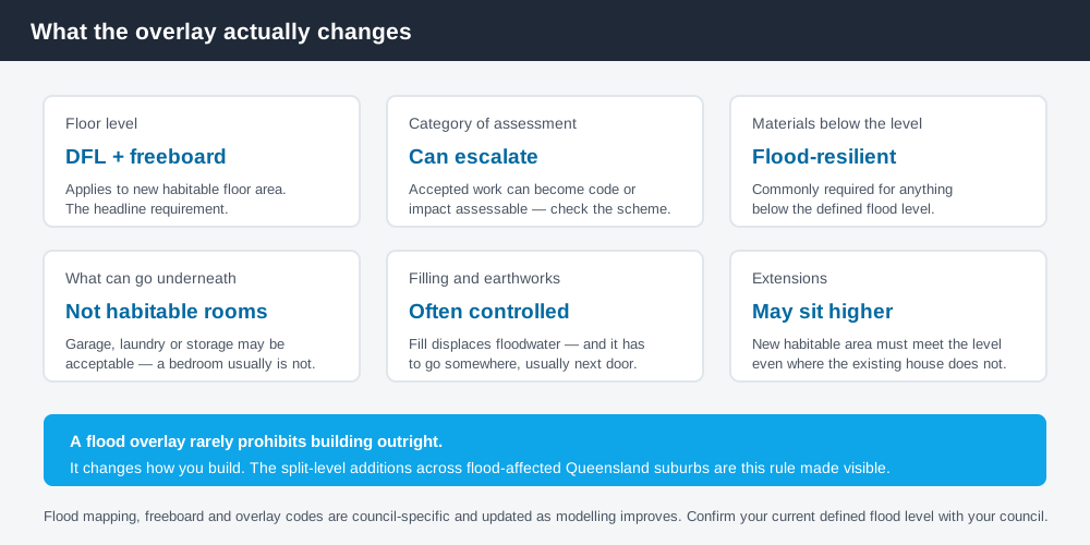
Figure 2: The design consequences, in the order they usually bite.
Extensions and existing houses
An existing house below the flood level is not unlawful, and you are not usually required to raise it. Extending it is where the question arises: many schemes apply the minimum floor level requirement to new habitable floor area, which can mean a new extension has to sit higher than the house it joins.
That produces the split-level additions common across flood-affected Queensland suburbs. It is worth knowing before you design a seamless single-level extension that cannot be approved. Council approval for an extension in QLD covers the wider set of issues an addition raises.
Flood status also affects insurance and resale, independently of anything a council decides. If you are buying, buying a flood-affected property in QLD sets out what to check before you commit.
Not all flood-prone land is the same
Councils generally distinguish between parts of a floodplain, and where your land sits within that distinction matters more than the fact of being mapped at all.
Land in an overland flow path or a floodway — where water moves at velocity during a flood — is treated far more restrictively than land in a flood storage or fringe area where water simply pools. The reason is that obstructing a flow path redirects water and changes the flood behaviour for everyone downstream and either side, whereas building above the level in a storage area mainly affects the building itself.
That distinction is why two neighbouring properties, both in the flood overlay, can face very different requirements. It is worth establishing which category your land falls into before you assume a neighbour's approved design is a precedent for yours.
Checking your own property
Start with your council, because council mapping and property-level flood information are the authoritative source for the overlay applying to your land, and many Queensland councils publish a property-specific flood report or flood level search. That is the document that gives you a defined flood level for your address.
At state level, the Queensland Globe provides free property and spatial mapping, and the Queensland Floodplain Assessment Overlay identifies potential floodplain areas at risk of riverine inundation. The Queensland Government's State Planning Policy pages provide access to the SPP interactive mapping system.
Read the state layers as indicative and the council mapping as the operative one. State layers are broad-scale; council flood models are usually far more detailed and are what your application is assessed against.
For the general process of identifying every overlay on a property, how to check overlays on a QLD property walks through it, and building in a QLD bushfire hazard area covers the other hazard overlay most likely to apply.
If you would rather see your zone, your overlays and your likely category of assessment in one document before you commission a design, an instantDA planning report does that for your address for $169 — against the $800–$1,500 a town planner typically charges for a preliminary opinion. You can start a report in a few minutes.
Because flood mapping is updated as modelling improves, confirm the current defined flood level with your council before you design to it.
Frequently asked questions
What is a defined flood level in Queensland?
What is the defined flood event?
What is freeboard?
Can I build on flood-prone land in Queensland?
Does my extension have to be higher than my house?
How do I check if my property floods?
Ready to generate your report?
Skip the writing. Get a council-ready planning report in 5 minutes.
Get your report