Key takeaways
- ✓A flood overlay rarely stops all development. It changes what you can build, how high the floors must be, and whether an application is needed at all.
- ✓The defined flood level plus a freeboard margin sets the minimum habitable floor level, and both are set by the council, not the state.
- ✓Councils divide flood land into risk categories. High and extreme categories are where new houses and new lots get restricted or refused.
- ✓In Brisbane the FloodWise Property Report is the technical document, and it is free. The Flood Awareness Map is the general one.
- ✓Flood constraints do not appear on a title search. Run the council flood search before the contract, or make the contract conditional on it.
Buying a Flood-Affected Property in QLD
You'll usually hear this called a development application, or DA — that's the formal name for council approval under the Planning Act 2016. On flood-affected land in Queensland, the flood overlay is often the single control that decides whether you need one, and what it will cost you to satisfy.
Flood is also the constraint most often discovered too late. It does not appear on the title, agents describe it inconsistently, and the difference between "the street flooded once" and "the lot is in a high hazard flood planning area" is the difference between a manageable design problem and a property you cannot do what you wanted with.
Get a council-ready planning report in 5 minutes — no planner, no waiting.
Get your report →The short answer
Queensland councils map flood-prone land in a flood hazard overlay and assess development against a flood overlay code. Being in the overlay usually raises minimum habitable floor levels, can make otherwise accepted development assessable, and in high hazard areas can prevent new dwellings and new lots.
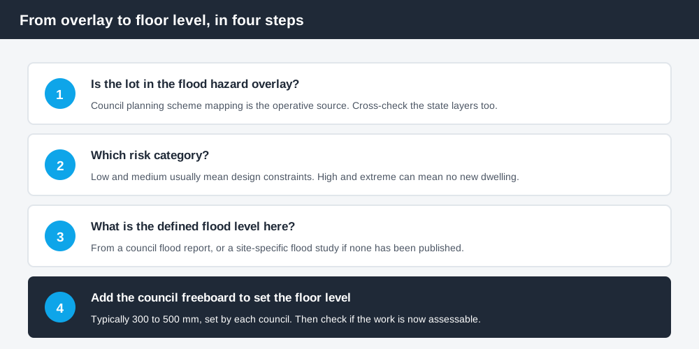
Figure 1: The overlay changes both the pathway and the design.
How flood is regulated
The State Planning Policy sets a state interest in natural hazards including flood, requiring planning schemes to keep new development compatible with the level of flood risk, avoid making flooding worse elsewhere, and use flood information to define flood planning areas. Councils implement that through a flood hazard overlay and an accompanying overlay code.
The Queensland Reconstruction Authority sits behind much of that mapping. It produces state-wide flood risk mapping and flood risk management guidance, and several councils have adopted its interim flood assessment overlay as an investigation area where more detailed local flood studies do not yet exist. Scenic Rim is one published example.
What this means for a buyer: the overlay on the council map is the operative control, but it may be derived from state data rather than a detailed local study, and it can change when a new study is completed.
Defined flood level and freeboard
Spend 5 minutes, not 3 weeks
instantDA generates a council-ready planning report for Queensland development applications. No town planner. No waiting.
Get your report →The defined flood event — commonly the 1% annual exceedance probability flood, often with a climate change allowance — produces a defined flood level for the site. Habitable floors must generally sit at or above that level plus a freeboard margin.
Freeboard is typically in the range of 300 to 500 millimetres, but it is set by each council and can differ by flood type within the same scheme. Rockhampton Regional Council's published guidance requires habitable floor levels 500 millimetres above the defined flood event. Sunshine Coast applies 300 millimetres of freeboard for stormwater flooding associated with drainage. These are not interchangeable numbers.
Non-habitable space — garages, laundries, storage — can often sit below that level, subject to flood-resilient construction and limits on what can happen there. Building work in a flood hazard area also carries obligations under the Queensland Development Code; confirm the current part and its requirements with your certifier or council rather than assuming.
Where no property-specific level has been published, councils commonly require a site-specific flood study to establish one. That is an engineering cost, and it belongs in your feasibility before the contract, not after.
- ✓Is the lot in the flood hazard overlay?
- ✓Which risk category?
- ✓What is the defined flood level for this address?
- ✓What freeboard does this council require?
- ✓Does the scheme allow a new dwelling in this category at all?
Risk categories change what is possible
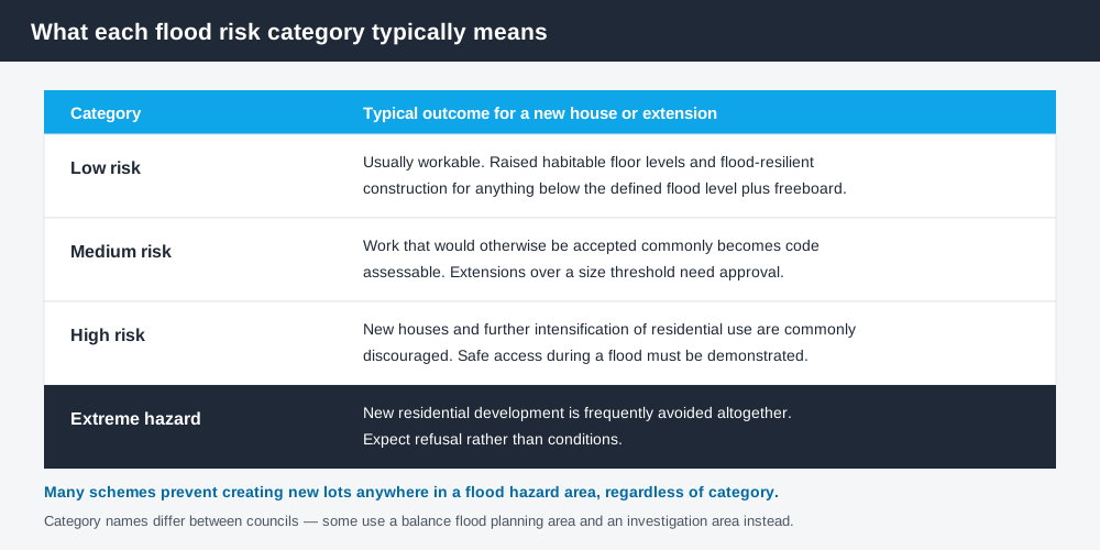
Figure 2: Category names vary between councils. The pattern does not.
Most schemes divide flood land into categories — low, medium, high and extreme, or equivalents such as a balance flood planning area and an investigation area. The consequences escalate sharply.
In low and medium categories, development is usually possible with raised floor levels and flood-resilient construction, and the main effect is that work which would otherwise be accepted becomes code assessable. Accepted versus assessable development in QLD explains what that change of category means for time and cost.
In high categories, councils commonly discourage new houses and further intensification of residential use, and require safe access during a flood.
In extreme hazard areas, new residential development is frequently avoided altogether, and many schemes prohibit creating new lots anywhere in a flood hazard area regardless of category.
Moreton Bay's published guidance is a useful illustration of how granular this gets: in its medium and high risk flood hazard areas, building a new dwelling house or extending an existing house by more than 50 square metres requires approval, including for outbuildings and secondary dwellings, while in the balance flood planning area smaller extensions can remain accepted if they meet the code.
Filling is not the easy answer
Buyers often assume the fix is to import fill and raise the pad. Flood overlay codes commonly restrict fill on flood-prone land, because filling removes floodplain storage and pushes water elsewhere. Where fill is allowed, compensatory storage — excavating elsewhere on the site to offset what you have taken — is often required, along with a stormwater management plan dealing with both water quality and peak flow.
Overland flow paths are a related trap. A lot can be outside the riverine flood overlay and still carry an overland flow path that constrains where a building can go.
The searches to run
Council planning scheme mapping. Find the flood hazard overlay and the risk category for the lot. How to check overlays in QLD covers the mechanics.
A property-specific flood report. In Brisbane, the FloodWise Property Report is the technical document: it gives the flood risk and levels used to set minimum habitable floor levels, and it is free from council's website. Brisbane's Flood Awareness Map is the general public-facing map, useful for context but not for design. Other councils run equivalent flood information searches — Sunshine Coast's flood information search is one example — and some charge a fee.
State mapping. Cross-check the address against the state floodplain assessment mapping and other layers on the Queensland Globe. State mapping sometimes shows exposure that an older council overlay has not yet picked up.
Insurance. Get a flood quote for the specific address before you are committed. Premiums on flood-mapped land can move a deal on their own.
Flood hazard overlays in QLD covers the overlay codes in more depth, and buying land to build on in QLD covers the wider pre-purchase check.
What to do next
Run the overlay check and the council flood search before you sign, or make the contract conditional on both. If you intend to build, extend or subdivide, take the defined flood level and the required freeboard to your designer early — a floor level set 500 millimetres higher changes stairs, access, driveway grades and cost.
If you'd rather see the zone, the overlays and the likely category of assessment for an address than work through a planning scheme yourself, an instantDA planning report does that for $169 — against the $800–$1,500 a town planner typically charges for a preliminary opinion. You can start a report in a few minutes.
Then confirm with your council. Flood mapping is updated as new studies are completed, and the duty planner will have the current position for your address.
Frequently asked questions
Does a flood overlay stop me building in Queensland?
What is a defined flood level?
What is freeboard?
Is the Brisbane FloodWise Property Report free?
Does flood risk show up on a title search?
Can I just fill the land to raise it above the flood level?
Ready to generate your report?
Skip the writing. Get a council-ready planning report in 5 minutes.
Get your report