Key takeaways
- ✓There is currently no minimum residential lot size specified under the State planning legislation in Queensland — every figure comes from a council planning scheme.
- ✓Lot area is only one test. Frontage width, average width, a minimum rectangle, corner lot rules and rear lot rules all sit alongside it.
- ✓The access handle of a rear lot is commonly excluded from the lot area calculation, which is what catches people out.
- ✓Figures differ sharply between councils: Noosa and South Burnett both use 600m² in low density residential, but South Burnett applies 100ha in specified rural areas.
- ✓Falling short of the figures does not end the project — it moves it to a harder, performance-based assessment.
Minimum Lot Sizes for Subdivision in QLD
Almost everyone searching for a minimum land size for subdivision in Queensland wants one number to measure their block against. In Queensland the process you are asking about is called reconfiguring a lot, or ROL, and you'll usually hear the approval itself called a development application, or DA, lodged with your council. The honest answer is that the single number does not exist at state level. It exists for your block, in your council's planning scheme, and it is almost never just an area figure.
Get a council-ready planning report in 5 minutes — no planner, no waiting.
Get your report →The short answer
There is currently no minimum residential lot size specified under the State planning legislation in Queensland. Every minimum lot size comes from an individual council's planning scheme and varies by zone, and often by overlay. Your number is in your zone code — nowhere else.
That is confirmed, and it is why no honest article can hand you a figure.
Why there is no Queensland-wide number
Under the Planning Act 2016 the State sets the framework for how development is categorised and assessed, but leaves the physical dimensions of lots to local government. Councils write minimum lot sizes into their planning schemes, working within State Planning Policies and, in the south-east, the SEQ Regional Plan.
Queensland schemes follow the Queensland Planning Provisions structure, so they look similar from the outside — same zone names, same code layout. That similarity is what misleads people. Each council layers its own numbers, codes and overlays on top, and they are not uniform between councils, or even between zones in the same council.
Lot area is only one of the tests
Spend 5 minutes, not 3 weeks
instantDA generates a council-ready planning report for Queensland development applications. No town planner. No waiting.
Get your report →The most expensive misunderstanding in subdivision is treating area as the whole question. A block can exceed the minimum area and still fail, because schemes control shape and access too.
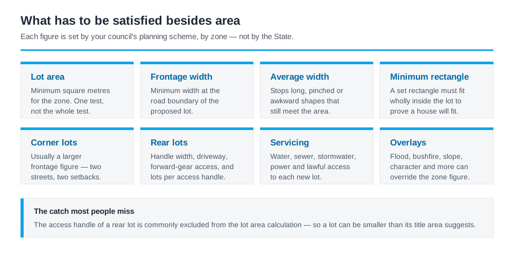
Figure 1: Area is one of at least seven things a new lot usually has to satisfy.
- ✓Minimum lot area for the zone
- ✓Minimum frontage or road boundary width
- ✓Minimum average lot width
- ✓A minimum rectangle that must fit wholly inside the lot
- ✓Separate rules for corner lots
- ✓Separate rules for rear lots and their access handles
- ✓Servicing — water, sewer, stormwater, power and access
- ✓Overlays affecting part or all of the site
The minimum rectangle test is the one people have never heard of. Schemes commonly require a rectangle of set dimensions to fit inside the proposed lot, clear of the frontage, to show a house and its private open space can be built. A long or awkwardly angled lot can hold plenty of square metres and still fail it. Average width does similar work: a lot that pinches in the middle averages out badly even where total area is generous.
How much the figures really differ
These are illustrations of variation, not the Queensland standard. Each belongs to the council that publishes it and applies nowhere else.
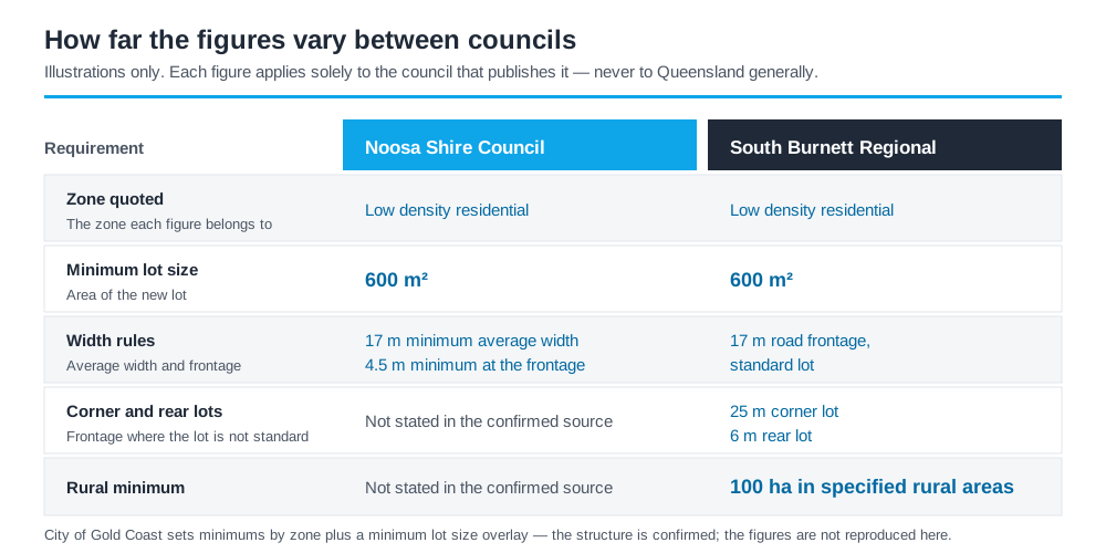
Figure 2: Confirmed figures from two councils, each attributable only to that council.
Noosa Shire Council sets a minimum lot size of 600m² in its Low density residential zone, with a minimum average width of 17m and a minimum 4.5m width at the frontage.
South Burnett Regional Council also uses 600m² in its Low density residential zone, with a minimum road frontage of 17m for a standard lot, 25m for a corner lot and 6m for a rear lot. In its Rural zone, specified rural areas carry a minimum of 100ha.
The City of Gold Coast structures it differently again: minimum lot sizes are set in the City Plan by zone and through a minimum lot size overlay, so the number for a property depends on reading the two together.
Two councils land on the same headline area but attach different width rules to it, and within one council the range spans four orders of magnitude. If a neighbour, an agent or a builder working in another region has quoted you a number, treat it as anecdote.
We could not confirm minimum lot size figures for Brisbane City Council, Logan City Council or the City of Moreton Bay from a council or planning scheme source. Numbers for those councils circulate in consultant summaries and forum posts, and we will not repeat them — a wrong figure at feasibility stage is worse than none. If your land is in one of those areas, read the current planning scheme and use Queensland Globe to confirm the zone and mapping for your parcel, then confirm with council.
Corner lots and rear lots, and the handle that disappears
Corner lots usually carry a larger minimum frontage, because they present to two streets and have to accommodate truncations, sight lines and setbacks on both. South Burnett's 25m corner figure against 17m standard shows that pattern.
Rear lots — battle-axe blocks — are where the arithmetic catches people. The access handle running out to the road is commonly excluded from the lot area calculation. That exclusion is common rather than universal, so check how your scheme words it, but where it applies, a 700m² rear lot with a long handle can land well under the minimum once the handle comes off.
Schemes also control the handle width, the driveway construction, whether a vehicle can leave in forward gear, whether services and refuse collection fit within the handle, and how many lots may take access from one handle. Somerset Regional Council, for example, manages rear lots through access strips, limiting how many lots take access from one strip and preventing rear lots being concentrated together. If your plan depends on a battle-axe lot, our guide to battle-axe blocks in Queensland covers the access and servicing side.
Meeting the numbers is not the same as being viable
A lot can satisfy every dimension and still be undeliverable. Overlays — flooding, bushfire, steep land, acid sulfate soils, character, environmental significance — sit over the zone and can restrict the developable area, dictate where a building envelope goes, or lift the level of assessment. Servicing does the same quietly: if water and sewer cannot reasonably be extended to the new lot, or stormwater cannot be lawfully discharged, the numbers stop mattering.
Because overlays are mapped separately from zoning, they are most often missed at feasibility stage. Checking what overlays affect your property before you commission a survey is cheap insurance.
How to find your own number
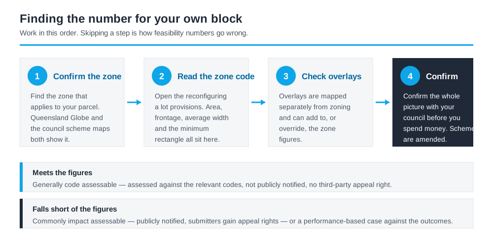
Figure 3: Four steps, in order, from address to a defensible number.
Work in this order. Confirm the zone that applies to your land. Open that zone code in the current planning scheme and find the reconfiguring a lot provisions — that is where the area, frontage, width and rectangle figures sit. Check the overlay maps for anything crossing your parcel and read the matching overlay codes, since they can add to or override the zone figures. Then confirm with council, because schemes are amended and the version you found online may not be in force.
If you would rather have the zone, the overlays and the likely level of assessment set out for your actual address, an instantDA planning report does exactly that for $169, against the $800–$1,500 a town planner typically charges for a preliminary opinion. You can start a report in a few minutes. For the approval process that follows, see our guide to reconfiguring a lot in Queensland.
What if your block falls short?
Failing the scheme's figures does not end the project. It changes the pathway. A proposal that meets the numbers is typically code assessable — assessed against the relevant codes, not publicly notified, no third-party appeal right. One that does not commonly becomes impact assessable: assessed against the whole planning scheme, publicly notified, with submitters gaining appeal rights.
Alternatively you may be able to run a performance-based argument, showing the proposal achieves the outcomes the code aims at even though it misses the stated figures. Either route is a much bigger piece of work: more technical reports, longer timeframes, higher cost and a genuinely uncertain outcome. Get advice before you commit.
Frequently asked questions
What is the minimum land size for subdivision in QLD?
Can I subdivide a 600m² block in Queensland?
Does the driveway of a battle-axe block count towards lot size?
Is frontage more important than area?
What happens if my lot is under the minimum size?
Where do I find the minimum lot size for my property?
Ready to generate your report?
Skip the writing. Get a council-ready planning report in 5 minutes.
Get your report