Key takeaways
- ✓Queensland Globe is free, browser-based, and basic use does not require an account.
- ✓It is the best free source for lot and plan, boundaries, aerial imagery and state-administered layers.
- ✓You need to log in only to save or share a map, add your own data, or use the georeferencing tools.
- ✓It is not a reliable source for your council's planning scheme zoning — that lives with the council.
- ✓The free A4 cadastral SmartMap is the quickest way to get a printable boundary map of a parcel.
Using Queensland Globe to Check a Property
You'll usually hear this called a development application, or DA — that's the formal name for council approval under the Planning Act 2016. Before you get anywhere near lodging one, you need to know what is actually on and under the land, and Queensland Globe is the best free tool the state provides for finding out.
It is also routinely oversold. Globe answers a specific set of questions extremely well and one important question not at all, and knowing which is which saves a lot of wasted time.
Get a council-ready planning report in 5 minutes — no planner, no waiting.
Get your report →The short answer
Queensland Globe is the state's free online mapping tool. It shows property boundaries, lot and plan details, aerial imagery, topography and hundreds of state-administered layers including vegetation and environmental data. Basic use needs no login. It is not a source for council planning scheme zoning.
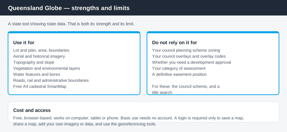
Figure 1: Globe is a state tool showing state data. That is both its strength and its limit.
What it is and what it costs
Queensland Globe is a free, browser-based interactive map published by the Queensland Government at qldglobe.information.qld.gov.au. It works on a computer, tablet or phone, and it gives access to a very large number of spatial layers — property, roads and rail, topography, valuations, vegetation, water, soil, mining and exploration, administrative boundaries and more.
Basic use requires no account. According to the tool's own help material, you only need to log in for a specific set of features: saving a map, sharing a map, adding your own imagery or data, and the georeferencing tools. Searching, adding layers, identifying features and measuring all work without signing in.
Getting something useful out of it quickly
Spend 5 minutes, not 3 weeks
instantDA generates a council-ready planning report for Queensland development applications. No town planner. No waiting.
Get your report →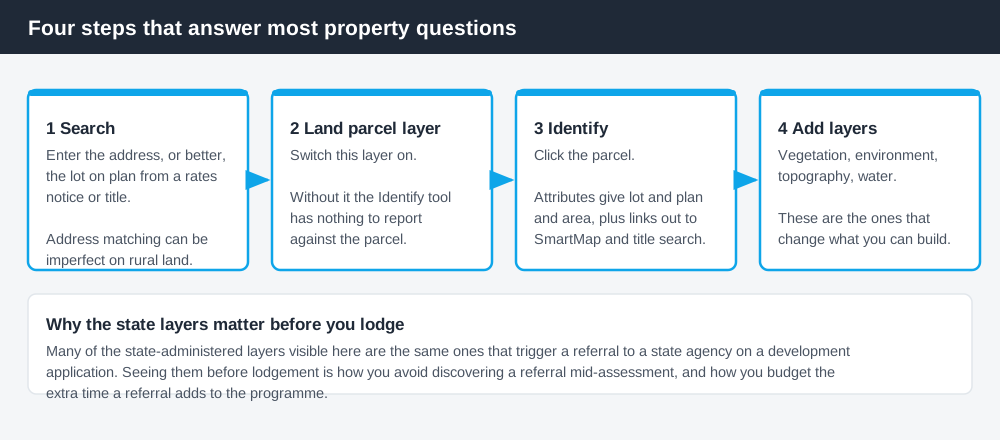
Figure 2: Four steps get you the information most property questions start with.
The workflow that answers most property questions is short.
Search the address or lot on plan. Globe accepts both. If you have a title or a rates notice, the lot on plan is more precise, because address matching can be imperfect on rural land and new estates.
Turn on the Land parcel layer. This is the one that makes the property information accessible. Without it, the Identify tool has nothing to report on the parcel.
Use the Identify tool on the parcel. The attributes panel gives you lot and plan, area, and — under the information and products section — links out to a SmartMap and a title search. Those are separate products, with Globe acting as the access point.
Add the layers relevant to your question. This is where the real value sits, and it is covered below.
For a printable boundary map, the state also offers a free pre-generated A4 cadastral SmartMap that you can download through Globe. For establishing where a boundary sits before a site meeting, that is usually enough.
- ✓Do you have the lot on plan, not just the address?
- ✓Is the Land parcel layer switched on?
- ✓Have you checked vegetation and environmental layers?
- ✓Have you looked at historical imagery for past structures?
- ✓Have you separately checked the council's zoning and overlays?
The layers that matter for a development question
Globe's layer list is long enough to be intimidating. For someone assessing whether a property can be developed, a handful do most of the work.
Land parcel and cadastre. Boundaries, lot and plan, area. The foundation for everything else.
Aerial and historical imagery. Underrated. Historical imagery shows what was on the site previously, which matters for questions about unapproved structures, past clearing, and whether a building is as old as the seller says.
Vegetation and environmental layers. Regional ecosystem mapping and matters of state environmental significance are among the most consequential constraints on rural and semi-rural land, and they are state-administered — which is exactly what Globe is for. Clearing that looks trivial can require a separate approval.
Topography. Slope drives a great deal: driveway feasibility, cut and fill, on-site wastewater capability, and whether a site can be built on at reasonable cost.
Water and inland waters layers. Watercourses, bores and related features, which connect to setbacks and to referral triggers.
Many of these state layers are also what generate a state referral on a development application. Seeing them before you lodge is how you avoid discovering a referral mid-assessment. The Planning Regulation 2017 explained covers how referrals get triggered.
What Globe will not tell you
This is the important part, because it is where people go wrong.
Your zoning. Zoning is set by your council's planning scheme. Globe is a state platform showing state data, and it should not be treated as a reliable source for each council's statutory zoning and overlay mapping. For your zone, precinct and overlays, use the council's own scheme mapping or property report. How to find out what zone your property is in covers where that lives.
Your council's overlays. Same reason. A flood hazard overlay in a planning scheme is a council instrument with a council code attached to it. State-level flood and hazard information exists and is useful, but it is not the same thing as the overlay that will condition your floor levels.
Whether you need approval. Globe shows constraints. It does not read the tables of assessment, and constraint mapping alone cannot tell you your category of assessment.
Easements and interests in full. Property-related layers can surface rights and interests information, but for a definitive position on easements and encumbrances, a title search is the answer, not a map.
How it fits with the other tools
Use Globe for state data and site context. Use your council's planning scheme mapping or property report for zone, precinct, overlays and assessment. Use a title search for the legal position — ownership, easements, covenants and encumbrances. Use council development application search tools to see what has been approved nearby.
Four tools, four jobs. The mistake is expecting any one of them to do all four.
What to do next
For a specific property, start with Globe for the site context and state layers, then go to the council for the planning position. In that order, because Globe is faster and often reveals the questions worth asking the council.
If you'd rather see the zone, the overlays and the likely category of assessment for an address pulled together in one place, an instantDA planning report does that for $169 — against the $800–$1,500 a town planner typically charges for a preliminary opinion. You can start a report in a few minutes.
Then confirm with your council. Mapping of any kind is indicative, and where a boundary line matters — a zone edge, an overlay extent, a vegetation boundary — the council or the relevant state agency is the one that settles it.
Frequently asked questions
Is Queensland Globe free?
Does Queensland Globe show property boundaries?
Does Queensland Globe show my zoning?
Can I get a property report from Queensland Globe?
What is the difference between Queensland Globe and QImagery?
Do I need a login to use Queensland Globe?
Ready to generate your report?
Skip the writing. Get a council-ready planning report in 5 minutes.
Get your report