Key takeaways
- ✓Zoning is set by your council's planning scheme, so the council's own mapping is the authoritative source for your address.
- ✓Queensland Globe is excellent for state layers and property boundaries, but it is not where your council's zone code lives.
- ✓The zone alone rarely answers the question you actually have. Precinct, overlays and local plans usually matter more.
- ✓Where several instruments apply, the highest level of assessment prevails.
- ✓Schemes are amended regularly — a zone you checked two years ago may have changed.
What Zone Is My Property?
You'll usually hear this called a development application, or DA — that's the formal name for council approval under the Planning Act 2016. Almost every question about whether you need one starts in the same place: what zone is the land in?
The zone is the foundation. It is also, on its own, less useful than most people expect, because the things that actually decide your application usually sit one layer down.
Get a council-ready planning report in 5 minutes — no planner, no waiting.
Get your report →The short answer
Your zone is set by your council's planning scheme, so the council's own scheme mapping or property report is the authoritative source. Queensland Globe is the best free tool for state layers and property boundaries, but it does not replace the council's zoning and overlay mapping for your address.
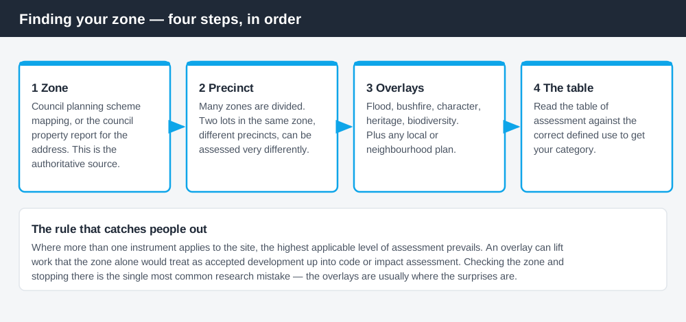
Figure 1: The zone is step one of four, and the later steps usually matter more.
Where the zone actually comes from
Queensland's planning schemes are made by local governments. The Planning Regulation 2017 sets out, in Schedule 2, the zones a local planning instrument may use and gives each a purpose statement — so councils choose from a fixed list of zone names rather than inventing their own. Everything below that level, including the zone code, the precincts, the tables of assessment and the built form controls, is written by your council.
That has one practical consequence worth holding onto: the council is the authoritative source for your zone. Anything else — a property listing, a third-party map, an old report, a neighbour's account — is secondhand and may be out of date.
The three places to look
Spend 5 minutes, not 3 weeks
instantDA generates a council-ready planning report for Queensland development applications. No town planner. No waiting.
Get your report →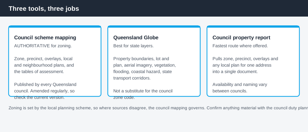
Figure 2: Different tools, different jobs. The council one is the one that governs.
Your council's planning scheme mapping. Every Queensland council publishes its planning scheme, including interactive or downloadable zone maps. This is the authoritative source. Larger councils also publish an address-based property report that pulls the zone, precinct, overlays and any local or neighbourhood plan into one document — usually the fastest route if it exists for your area.
Queensland Globe. The state's free mapping platform, at qldglobe.information.qld.gov.au. It is genuinely excellent for property boundaries, lot and plan details, aerial imagery, and state-administered layers such as vegetation, flooding, coastal hazard and state transport corridors. What it is not is a substitute for your council's zone code and tables of assessment.
The state planning portal. The Queensland Government publishes guidance on zoning and the planning framework at planning.qld.gov.au, which is the right place to understand how the system fits together rather than to look up a specific address.
- ✓Get the lot and plan number for the property
- ✓Find the zone in the council's scheme mapping
- ✓Note the precinct, if the zone has one
- ✓List every overlay that touches the site
- ✓Check for a local plan or neighbourhood plan
- ✓Read the table of assessment for what you actually want to do
What the zone tells you, and what it doesn't
The zone tells you the council's intent for the area and points you to the zone code. That is a real answer, and for some questions it is enough.
What it frequently does not tell you is whether your specific proposal needs approval, because three other things commonly override it.
Precincts. Many zones are divided into precincts that change what is anticipated. Two properties in the same zone in different precincts can face very different assessment. Brisbane's Character residential zone, for example, has distinct precincts with different expectations about additional housing.
Overlays. Flood, bushfire, character, heritage, biodiversity, acid sulfate soils, coastal hazard — overlays sit on top of the zone and carry their own codes. An overlay commonly raises the category of assessment for work that the zone alone would treat lightly. Where several instruments apply, the highest applicable level of assessment prevails. How to check which overlays apply to your property covers this layer specifically.
Local and neighbourhood plans. These sit over particular areas and can substantially change both what is anticipated and how it is assessed.
The defined use trap
Even with the zone, precinct and overlays in hand, one step remains, and it trips up a lot of otherwise careful research.
Queensland schemes assess proposals against defined uses, and those definitions do not always match everyday language. What you call a granny flat is a secondary dwelling. What you call a cafe may be a food and drink outlet. What you call a home office may or may not be a home based business depending on staff, visitors and vehicle movements.
The table of assessment is organised by defined use, so if you look up the wrong term you will read the wrong row. When you are unsure, the scheme's administrative definitions section is the place to settle it — or ask the council's duty planner, who deals with this daily.
Reading the result
Once you have the zone, precinct, overlays and the correct defined use, the table of assessment gives you the category: accepted development, accepted subject to requirements, code assessable or impact assessable. Those are meaningfully different positions, and the difference drives time, cost and whether neighbours can make submissions and appeal.
Two cautions before you rely on what you find.
Schemes are amended regularly. A zone or precinct you checked a couple of years ago may have changed, and amendments are not always widely publicised. Take the current position each time.
The map boundary is not always where you think. Zone and overlay boundaries can cut through a lot. If your site sits near an edge, get the council to confirm which side of the line the relevant part of the land falls on before you design around it.
What to do next
Pull the council property report for your address if one is available, then check the zone, precinct and every overlay, and read the table of assessment against the correct defined use.
If you'd rather see the zone, the overlays and the likely category of assessment for an address pulled together in one place, an instantDA planning report does that for $169 — against the $800–$1,500 a town planner typically charges for a preliminary opinion. You can start a report in a few minutes.
Then confirm with your council. A duty planner will tell you in a short conversation whether your reading of the table is right, and that check is free. If your address turns out to be in a zone that behaves unusually, the Emerging community zone explained and the Rural residential zone explained cover two of the ones that most often surprise owners.
Frequently asked questions
How do I find out what zone my property is in Queensland?
Does Queensland Globe show my zoning?
Is zoning the same across Queensland councils?
What is more important, the zone or the overlays?
How often does zoning change?
What if my property sits on a zone boundary?
Ready to generate your report?
Skip the writing. Get a council-ready planning report in 5 minutes.
Get your report