Key takeaways
- ✓A survey plan defines your new lot boundaries in a form the titles registry can accept — it is not a site survey, a contour survey or a boundary identification survey.
- ✓Only a registered cadastral surveyor may carry out the cadastral survey and certify the plan for registration.
- ✓The Land Title Act 1994 recognises three registrable formats: standard format, building format and volumetric format.
- ✓Plan sealing is council certifying that your approval conditions are met and infrastructure charges paid — it is where most subdivisions stall.
- ✓New titles only exist once Titles Queensland registers the sealed plan.
- ✓Where the approval states no period, a reconfiguring a lot approval lapses if the plan is not given to council within four years — Planning Act 2016 s 85.
Survey Plans and Titles After Subdivision in QLD
Most people call it "getting the new titles" or "splitting the block". You'll usually hear the approval side of this called a development application, or DA — in Queensland the subdivision itself is called reconfiguring a lot, or ROL. But the part that actually creates the new lots isn't the approval at all. It's a survey plan, prepared and certified after the earthworks and pipes are finished, sealed by council, and then registered.
This is the back half of a subdivision, and it is the half people underestimate. The approval is a permission. The survey plan is the instrument that turns that permission into two pieces of land you can sell, mortgage or build on separately.
Get a council-ready planning report in 5 minutes — no planner, no waiting.
Get your report →The short answer
A survey plan is the document a registered cadastral surveyor prepares to define your new lot boundaries in a form the titles registry can register. Council seals it once your approval conditions and infrastructure charges are satisfied, then Titles Queensland registers it — and only then do the new titles exist.
What a survey plan is — and what it is not
A survey plan does one job: it defines boundaries in a form the registry will accept. It reduces a physical piece of ground to bearings, distances, marks and lot numbers that can be entered on the register and relied on by anyone who later buys, lends against or builds on the land. It is a legal instrument, not a drawing for your architect.
That matters because "survey plan" is a phrase people use for at least three different documents, and ordering the wrong one costs weeks.
- ✓A survey plan defines new lot boundaries for registration — the subdivision document
- ✓A site or detail survey records levels, contours, trees, services and existing structures so a designer can draw a proposal — it registers nothing
- ✓An identification survey re-establishes where an existing boundary physically runs, usually for a fence or encroachment dispute — it also registers nothing
All three are usually carried out by surveyors, but only the first is a subdivision instrument. If your builder asked for "a survey", they mean a detail and contour survey for design. If your neighbour's fence is over the line, you want an identification survey. Say which one you mean when you ask for a quote.
Only a registered cadastral surveyor can certify it
Spend 5 minutes, not 3 weeks
instantDA generates a council-ready planning report for Queensland development applications. No town planner. No waiting.
Get your report →This is not a step you can shop around on price alone, because the pool of people legally able to do it is closed. Only a registered cadastral surveyor may carry out the cadastral survey and certify the plan for registration. The registry will not register a subdivision plan certified by anyone else, no matter how competent the drafting.
Registration of surveyors is administered by the Surveyors Board of Queensland under the Surveyors Act 2003, and the work itself sits inside the framework set by the Survey and Mapping Infrastructure Act 2003 and the Land Title Act 1994.
The three registrable plan formats
The Land Title Act 1994 recognises three plan formats, and the right one is decided by what you are actually creating — not by preference.
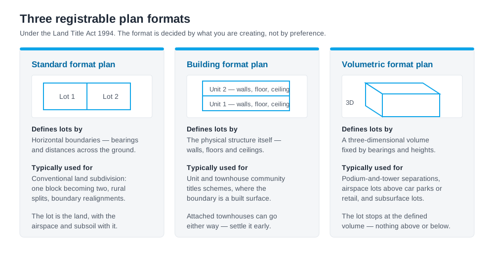
Figure 1: The three registrable plan formats under the Land Title Act 1994 and what each is used for.
A standard format plan defines lots horizontally, by bearings and distances measured across the ground. This is the conventional land subdivision: one suburban block becoming two, a rural lot being split, a boundary realignment between neighbours.
A building format plan defines lots by reference to the physical structure — the walls, floors and ceilings of the building itself. This is the format used for unit and townhouse community titles schemes, where the boundary is a plastered surface rather than a peg in the ground.
A volumetric format plan defines a lot as a three-dimensional volume, fixed in space by bearings, distances and heights. It is the format for podium-and-tower separations, airspace lots above a car park or retail level, and subsurface lots such as basements or tunnels running under other land.
From civil works to new titles: who does what
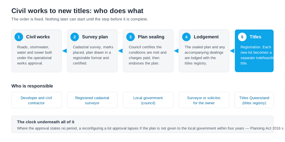
Figure 2: The sequence from finished civil works to registered titles, and who is responsible at each step.
The order is fixed. Your civil works — the roads, stormwater, water and sewer required by your conditions — are built under an operational works approval and inspected by council. Only once those are substantially complete does the surveyor return to the site, place the survey marks and prepare the plan. The surveyor then applies to council for plan sealing, usually on your behalf. Council seals. The sealed plan is lodged with Titles Queensland. Titles Queensland registers it, and each new lot becomes a separate indefeasible title under the Land Title Act 1994.
If you are earlier in the process than this, the design and construction stage is covered in operational works in Queensland, and the approval that sits above all of it is explained in reconfiguring a lot.
Plan sealing: the stage projects stall at
Plan sealing is council certifying that the conditions of your development approval have been met and that the infrastructure charges have been paid, and then endorsing the plan so it can be lodged.
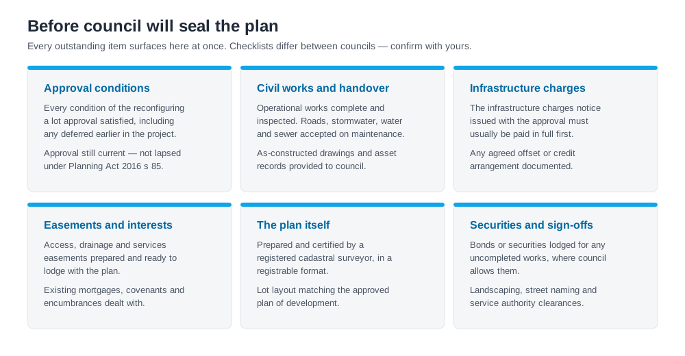
Figure 3: The categories council works through before it will seal a plan. Requirements vary between councils — confirm with yours.
Projects stall here for a structural reason: every outstanding condition surfaces at once. A condition you deferred at month three, an easement you never registered, a bond you never lodged, a landscaping item nobody signed off, a charge sitting unpaid — none of them block anything until sealing, and then all of them block sealing simultaneously. Councils publish their own plan sealing checklists and they are not uniform; the City of Gold Coast plan sealing page shows the level of detail typically involved. Confirm the requirements with your own council early.
Infrastructure charges are commonly required to be paid before council will seal — the mechanics of the charges notice are set out in infrastructure charges in Queensland.
Lodgement and registration with Titles Queensland
Once sealed, the plan is lodged with Titles Queensland, which operates the Queensland Titles Registry. Registration is the moment the new lots legally exist: each is issued as a separate indefeasible title under the Land Title Act 1994, with its own lot on plan description. Any easements, covenants or administrative advices that go with the subdivision are dealt with as part of the same lodgement, which is why unregistered easements are such a reliable cause of delay.
The clock: four years, unless your approval says otherwise
A reconfiguring a lot approval does not last forever. Under the Planning Act 2016 s 85, where the approval itself states no period, the approval lapses if the plan is not given to the local government within four years. An extension can be requested, but it must be requested before the approval lapses — not after.
Four years sounds generous until you price in design, an operational works approval, construction, wet weather and a sealing round. Letting an approval lapse means starting the application again under whatever scheme is current then.
If you want the planning position for your own address set out before you commit to a surveyor — the zone, the overlays and what a reconfiguring a lot proposal would face there — an instantDA planning report covers it for $169, against the $800–$1,500 a town planner typically charges for a preliminary opinion. You can start a report in a few minutes.
Frequently asked questions
What is a survey plan in Queensland?
Who can prepare a survey plan in QLD?
What is the difference between a standard format plan and a building format plan?
What does plan sealing mean?
How long do I have to lodge the plan after a subdivision approval?
Is a survey plan the same as a site survey?
Ready to generate your report?
Skip the writing. Get a council-ready planning report in 5 minutes.
Get your report