Key takeaways
- ✓Acid sulfate soils are naturally occurring and harmless while undisturbed and waterlogged — the problem is exposing them to air.
- ✓The trigger is usually disturbance, not the presence of the soils: excavation below a nominated level or beyond a nominated volume.
- ✓Land at or below 5m AHD in coastal local government areas is the commonly used mapping threshold.
- ✓The state guidance is the Queensland Acid Sulfate Soils Technical Manual, applied through council overlay codes.
- ✓The cheapest response is almost always to design so you do not disturb them — a pool or basement is what usually triggers it.
Acid Sulfate Soils and Your QLD Development Application
Of all the overlays that can appear on a Queensland property report, acid sulfate soils is the one owners are least likely to have heard of and most likely to dismiss. It sounds like a contamination problem. It is not — the soils are naturally occurring and completely harmless where they are.
The problem is chemistry, and it starts the moment you dig them up.
Get a council-ready planning report in 5 minutes — no planner, no waiting.
Get your report →The short answer
Acid sulfate soils are naturally occurring soils containing iron sulfides, harmless while waterlogged but generating sulfuric acid when exposed to air. Assessment is triggered by disturbance — typically excavation below a nominated level, commonly 5m AHD in coastal areas, or beyond a nominated volume — under your council's overlay code.
Note the framing. The overlay does not stop you building. It regulates digging.
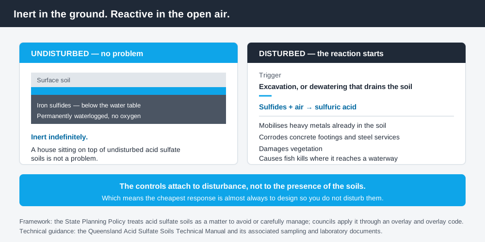
Figure 1: Inert in the ground, reactive in the open air.
What they actually are
Acid sulfate soils contain iron sulfides, laid down in coastal and estuarine environments over thousands of years. Below the water table they are permanently waterlogged, oxygen cannot reach them, and they sit inert indefinitely.
Excavate them, or lower the water table so they drain, and oxygen reaches the sulfides. The reaction produces sulfuric acid. That acid can mobilise heavy metals naturally present in the soil, corrode concrete footings and steel services, kill vegetation, and — if it reaches a waterway — cause fish kills.
That is why the controls attach to disturbance rather than to the presence of the soils. A house that sits on top of undisturbed acid sulfate soils is not a problem. A basement, a pool excavation or a drainage cut is.
What triggers assessment
Spend 5 minutes, not 3 weeks
instantDA generates a council-ready planning report for Queensland development applications. No town planner. No waiting.
Get your report →Queensland's State Planning Policy treats acid sulfate soils as a matter to be avoided or carefully managed, and councils give that effect through an acid sulfate soils overlay and overlay code in the planning scheme.
Triggers are usually expressed as a combination of location and disturbance.
- ✓Location — land at or below a nominated level, commonly 5m AHD in coastal local government areas, and in some schemes land below a higher elevation where the mapping indicates
- ✓Depth — excavation below a nominated depth or below the natural water table
- ✓Volume — excavation or filling beyond a nominated quantity of material
- ✓Dewatering — any activity that lowers the water table and drains previously waterlogged soil
Volume thresholds are used because small excavations disturb small quantities of material that can be managed simply, while large earthworks cannot. The specific figures are set by your council's overlay code and differ between councils, so read yours rather than relying on a number from elsewhere.
What an investigation involves
Where the trigger is met, the overlay code typically requires an acid sulfate soils investigation followed, if soils are confirmed, by a management plan.
The investigation involves a site investigation and sampling regime, laboratory analysis of the samples to determine acidity and sulfide content, and usually a groundwater assessment to establish the water table. The state guidance for this work is the Queensland Acid Sulfate Soils Technical Manual and its associated sampling and laboratory guidance.
If soils are confirmed and disturbance is unavoidable, an acid sulfate soils environmental management plan documents the management approach. Queensland Government guidance indicates the approach should, where possible, avoid disturbing the soils at all, and otherwise neutralise acidity, prevent mobilisation of contaminants, manage groundwater appropriately, treat disturbed material before disposal, and set out reporting and implementation requirements.
Practically, treatment usually means applying agricultural lime to disturbed material at a calculated rate, in a controlled area, with verification testing — which is why the cost scales with the volume of material you disturb.
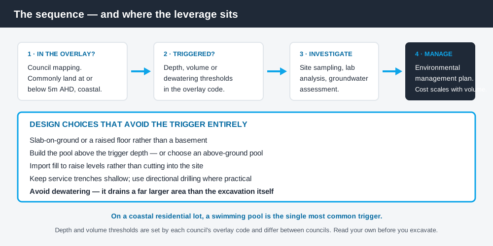
Figure 2: The sequence, and where the design leverage sits.
The design decision that avoids it
Because the trigger is disturbance, the cheapest response is almost always to reduce disturbance rather than to manage it.
- ✓Use a slab-on-ground or raised floor rather than a basement
- ✓Site a pool where it can be built above the trigger depth, or choose an above-ground pool
- ✓Import fill to raise levels rather than cutting into the site
- ✓Keep service trenches shallow and use directional drilling where practical
- ✓Avoid dewatering — it disturbs a much larger area than the excavation itself
Pools are the single most common trigger on a residential lot in a coastal Queensland suburb, because a pool excavation goes deep by definition and often reaches the water table. Council approval for a pool in QLD covers the wider approval picture for pools.
For subdivisions and civil work, the earthworks are the exposure, and the assessment sits within the operational works application — operational works in QLD explains where that fits in the sequence.
Dewatering deserves particular attention. Pumping groundwater out of an excavation lowers the water table across a much larger area than the hole itself, exposing soils well beyond your site boundary. Councils treat it seriously and it is worth designing around.
What it costs, and why the number moves so much
There is no useful single figure, because the cost is driven almost entirely by the volume of material you disturb and by whether the soils turn out to be present at all.
At the light end, a preliminary investigation on a small residential site — a limited sampling regime and laboratory analysis to establish whether acid sulfate soils are actually present at the depths you propose to reach — is a modest specialist report. Plenty of these come back clear, and the matter ends there.
At the heavy end, a confirmed presence combined with substantial earthworks means a management plan, a controlled treatment area on site, lime applied at a calculated rate, verification testing, and disposal arrangements for material that cannot be treated in place. That is a civil operation rather than a report, and it scales with cubic metres.
Which is why the design advice above is worth taking seriously before the quote stage rather than after. The gap between a design that reaches the trigger depth and one that stops short of it can be the difference between a single preliminary report and a managed excavation.
If soils are confirmed
Confirmation is not a refusal. It means the application will carry a management plan and the works will carry conditions — verification testing, reporting, and a requirement that treatment is carried out in accordance with the plan.
The condition most often underestimated is the reporting obligation after the works. Councils commonly require validation that the management plan was actually implemented, which means keeping records during construction rather than reconstructing them afterwards. Tell your builder about this at contract stage, not when the report falls due.
Check your own position
Check your council's acid sulfate soils overlay mapping and read the overlay code for the actual triggers and thresholds. General property and spatial information is available on the Queensland Globe, and the Queensland Government's acid sulfate soils guidance covers the technical framework and management approach.
Coastal properties frequently carry more than one overlay, and acid sulfate soils commonly sits alongside coastal hazard and flood. Coastal hazard areas and QLD development covers the coastal side, and how to check overlays on a QLD property walks through identifying all of them at once.
If you would rather see your zone, your overlays and your likely category of assessment in one document before you commission a design, an instantDA planning report does that for your address for $169 — against the $800–$1,500 a town planner typically charges for a preliminary opinion. You can start a report in a few minutes.
Because triggers and thresholds differ between councils, confirm the applicable requirement with your council before you excavate.
Frequently asked questions
What are acid sulfate soils?
What triggers an acid sulfate soils assessment in Queensland?
Do acid sulfate soils stop me building?
What does an acid sulfate soils investigation involve?
Does a swimming pool trigger acid sulfate soils assessment?
Why does dewatering matter so much?
Ready to generate your report?
Skip the writing. Get a council-ready planning report in 5 minutes.
Get your report