Key takeaways
- ✓Coastal hazard covers two different things — erosion, and storm tide inundation. They are mapped separately and controlled differently.
- ✓The Coastal Protection and Management Act 1995 provides for erosion prone areas and the coastal management district.
- ✓Erosion prone area width is calculated, not fixed — it accounts for long-term erosion, storm effects, sea level rise and a safety factor.
- ✓State coastal hazard mapping and council coastal hazard overlays generally apply together rather than instead of each other.
- ✓Coastal lots commonly carry three overlays at once — coastal hazard, flood and acid sulfate soils.
Coastal Hazard Areas and QLD Development
Queensland has more coastline than any other Australian state, and a great deal of it is built on. Coastal hazard controls are how the planning framework manages the fact that the shoreline is not a fixed line — it moves, over decades and sometimes in a single night.
For an owner, the practical question is narrower: what does the overlay actually stop you doing, and what does it merely change.
Get a council-ready planning report in 5 minutes — no planner, no waiting.
Get your report →The short answer
Coastal hazard covers two distinct things. Erosion is managed through erosion prone areas declared under the Coastal Protection and Management Act 1995. Storm tide inundation is mapped separately and controlled more like flood, through floor levels. State mapping and council coastal hazard overlays generally apply together.
Separating the two is the first useful step, because the responses to them are completely different.
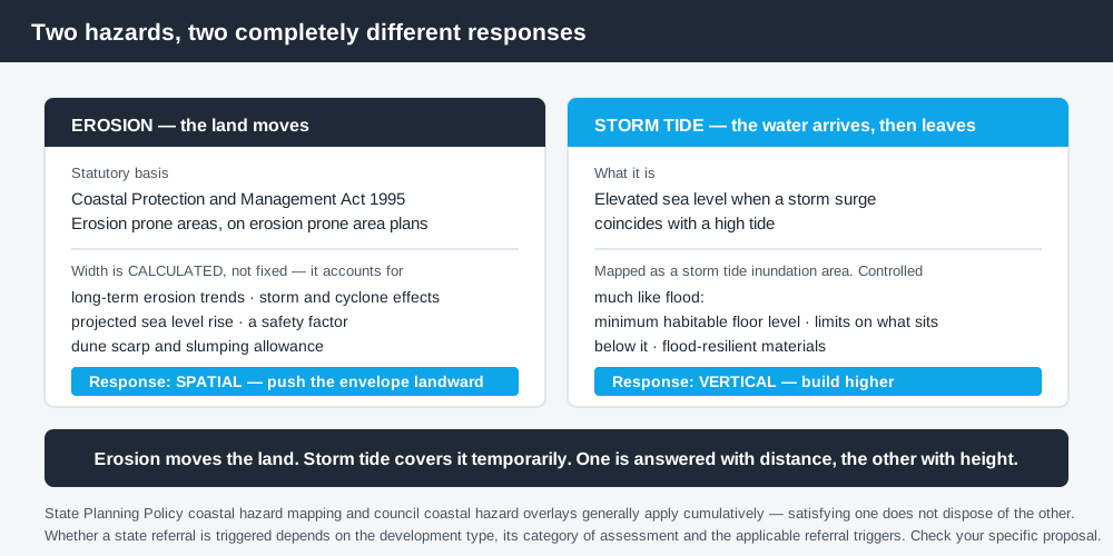
Figure 1: Two hazards, two very different responses.
Hazard one — erosion
The Coastal Protection and Management Act 1995 provides the statutory basis for coastal management in Queensland, including erosion prone areas and the coastal management district.
An erosion prone area identifies land vulnerable to erosion and coastal processes. Queensland Government guidance indicates erosion prone areas have been declared for coastal local government areas and are shown on erosion prone area plans used in development assessment.
The width of an erosion prone area is not a single fixed figure. It is calculated using a technical methodology that accounts for long-term erosion trends, the effect of storms and cyclones, projected sea level rise, a safety factor, and an allowance for dune scarp and slumping. That is why the width varies enormously along the coast — a stable rocky headland and an actively receding sand beach produce very different numbers.
The response to erosion risk is spatial. It is about where you build, not how high. Development is generally pushed landward, away from the active zone, and permanent structures within the erosion prone area attract close scrutiny.
Hazard two — storm tide inundation
Spend 5 minutes, not 3 weeks
instantDA generates a council-ready planning report for Queensland development applications. No town planner. No waiting.
Get your report →Storm tide is the elevated sea level produced when a storm surge coincides with a high tide, and it is mapped as a storm tide inundation area. Unlike erosion, it does not move the shoreline — it temporarily floods land behind it.
The response is therefore much closer to the flood response: a minimum habitable floor level, restrictions on what can sit below that level, flood-resilient materials, and in some cases evacuation considerations for more vulnerable uses. If you have read about defined flood levels and freeboard, the logic will be familiar — building on flood-prone land in QLD sets that framework out, and many coastal properties are subject to both.
How state and council controls fit together
Queensland's State Planning Policy identifies coastal hazard interests including erosion prone areas and storm tide inundation areas. Councils then apply local coastal hazard overlays in their planning schemes with more detailed local controls.
These generally operate cumulatively rather than alternatively. Where both apply, the proposal is assessed against the state interest and the local planning scheme, so satisfying the council overlay does not dispose of the state position.
Whether a state referral is triggered depends on the type of development, whether it is assessable, the applicable coastal mapping and the referral triggers in the planning framework. There is no simple rule that all development in a coastal management district is referred, so check the specific position for your proposal rather than assuming either way.
Queensland's planning schemes follow the Queensland Planning Provisions structure, but each council layers its own overlays and mapping on top. They are not uniform.
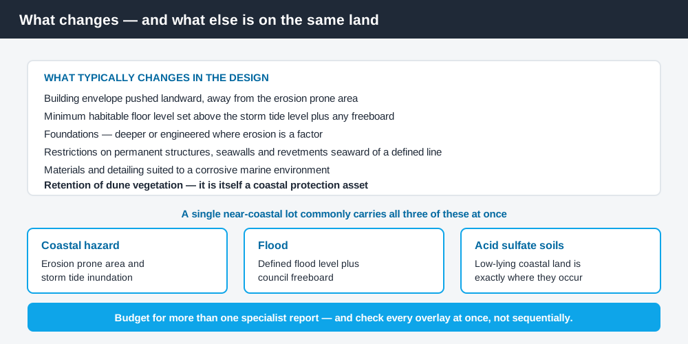
Figure 2: What changes in practice, and what else is usually mapped on the same land.
What typically changes in a design
- ✓Building envelope pushed landward, away from the erosion prone area
- ✓Minimum habitable floor level set above the storm tide level plus any freeboard
- ✓Foundation design — deeper or engineered footings where erosion is a factor
- ✓Restrictions on permanent structures, seawalls and revetments seaward of a defined line
- ✓Materials and detailing suited to a corrosive marine environment
- ✓Retention of dune vegetation, which is itself a coastal protection asset
Dune vegetation deserves particular attention. It is frequently protected by more than one instrument at once — coastal controls, a council biodiversity overlay, and sometimes a local law — and clearing it is a common source of enforcement action. Vegetation clearing and biodiversity overlays in QLD covers how those layers stack up.
Existing houses are generally not required to move or be raised. The controls bite on new development, substantial redevelopment and, in many schemes, extensions that add habitable floor area.
Coastal lots carry multiple overlays
This is the practical reality that most affects a coastal project budget. A single beachfront or near-coastal lot in Queensland commonly sits within a coastal hazard overlay, a flood overlay, and an acid sulfate soils overlay simultaneously — the last because low-lying coastal land is exactly where acid sulfate soils occur.
Each has its own assessment requirements and potentially its own specialist report. Acid sulfate soils and your QLD development application explains that one, and it is the overlay most likely to be overlooked until a pool or footing excavation is designed.
Budget for the possibility of more than one specialist report, and check all the overlays at once rather than discovering them sequentially.
Seawalls and the temptation to armour
The instinctive response to erosion risk is a wall, and it is worth understanding why the framework is cautious about them.
A seawall or revetment protects the land immediately behind it, but it does so by reflecting wave energy rather than absorbing it. The consequence is usually accelerated scour at the base of the wall and at its ends, which transfers the erosion problem to the properties either side and can remove the beach in front of it entirely. That is why permanent structures seaward of a defined line attract close scrutiny, and why coastal controls generally favour setback and dune retention over armouring.
For an individual owner this can feel unfair, particularly when a neighbouring property has an older wall built under a different regime. It is nonetheless the position the framework takes, and a design premised on obtaining approval for new hard protection is a risky one.
Buying near the coast
If you are looking at a coastal property rather than already holding one, the checks worth doing before contract are specific and quick.
- ✓The council's coastal hazard overlay mapping and the overlay code for the property
- ✓The erosion prone area plan and where the line sits relative to the existing dwelling
- ✓The storm tide inundation mapping and any defined level for the site
- ✓Whether a flood overlay also applies, and the defined flood level
- ✓Whether an acid sulfate soils overlay applies, and at what trigger depth
- ✓Whether any existing structure sits seaward of a line that would prevent its replacement
That last one is the sleeper. An existing dwelling can be entirely lawful where it stands and still be in a position where a replacement dwelling on the same footprint would not be supported. If your plan for the property involves knocking down and rebuilding, establish that before you buy rather than after.
Check your own position
Check your council's coastal hazard overlay mapping and read the overlay code, then check the state coastal hazard mapping and the erosion prone area plan for your area. The Queensland Government's erosion prone areas guidance explains how the areas are declared and used, and general property and spatial information is on the Queensland Globe.
For the general process of identifying every overlay on a property at once, how to check overlays on a QLD property walks through it.
If you would rather see your zone, your overlays and your likely category of assessment in one document before you commission a design, an instantDA planning report does that for your address for $169 — against the $800–$1,500 a town planner typically charges for a preliminary opinion. You can start a report in a few minutes.
Because coastal mapping is revised as modelling and monitoring improve, confirm the current position with your council before you design to it.
Frequently asked questions
What is an erosion prone area in Queensland?
How wide is an erosion prone area?
What is the difference between coastal erosion and storm tide inundation?
Can I build in a coastal hazard area in Queensland?
Do state and council coastal controls both apply?
Why do coastal properties have so many overlays?
Ready to generate your report?
Skip the writing. Get a council-ready planning report in 5 minutes.
Get your report