Key takeaways
- ✓City Plan 2014 commenced on 30 June 2014 and has been amended many times. Always check you are reading the current version.
- ✓Four things decide your answer: the zone, any neighbourhood plan, any overlays, and the table of assessment.
- ✓Where more than one table applies, the highest level of assessment prevails.
- ✓The property report is the fastest way to see zone, neighbourhood plan and overlays for an address in one place.
- ✓Neighbourhood plans and overlays frequently override what the zone alone would suggest.
Brisbane City Plan 2014 Explained
You'll usually hear this called a development application, or DA — that's the formal name for council approval under the Planning Act 2016. In Brisbane, whether you need one, and what it will be assessed against, is decided by Brisbane City Plan 2014.
City Plan is large, and most people who open it give up before finding the answer. The good news is that it is not disorganised — it just requires you to look things up in a particular order, and almost nobody is told what that order is.
Get a council-ready planning report in 5 minutes — no planner, no waiting.
Get your report →The short answer
Brisbane City Plan 2014 commenced on 30 June 2014 and is Brisbane City Council's planning scheme. Four things decide your answer: the zone, any neighbourhood plan, any overlays, and the table of assessment that combines them. Where tables conflict, the highest level of assessment prevails.
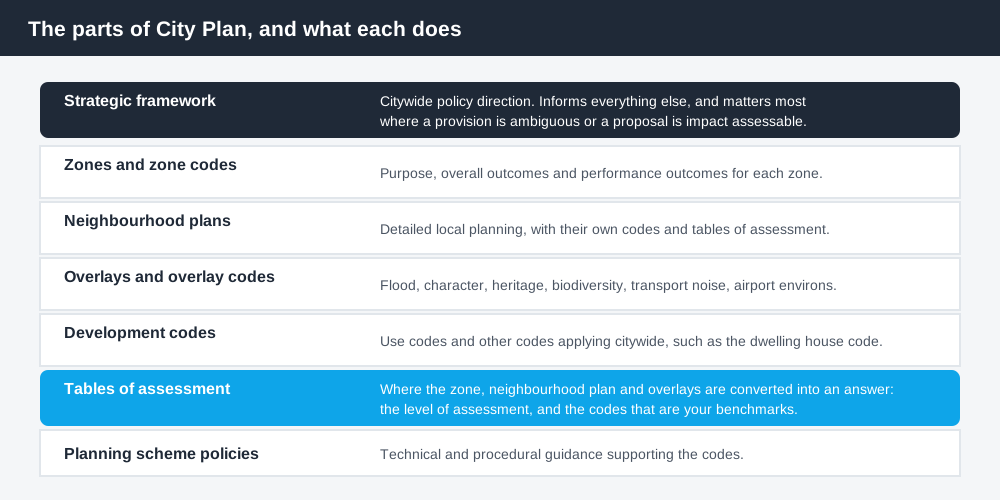
Figure 1: The parts, and what each one does.
How City Plan is put together
City Plan is arranged in parts, and each part does a different job.
Strategic framework. The citywide policy direction and long-term vision. It informs everything else and matters most when a provision is ambiguous or when a proposal is impact assessable.
Zones and zone codes. Every parcel sits in a zone, and the zone code sets the purpose, overall outcomes and performance outcomes for development there.
Neighbourhood plans. Detailed local planning for particular areas, with their own codes and their own tables of assessment. If your property is in one, it frequently matters more than the zone.
Overlays and overlay codes. Mapped constraints and features — flood, character, heritage, biodiversity, transport noise, airport environs — with codes that manage development where they apply.
Development codes. Use codes and other development codes applying citywide, such as the dwelling house code, multiple dwelling code and reconfiguring a lot code.
Tables of assessment. The lookup tables that say, for each type of development, what level of assessment applies and which codes are the benchmarks.
Planning scheme policies. Technical and procedural guidance supporting the codes.
The four things that decide your answer
Spend 5 minutes, not 3 weeks
instantDA generates a council-ready planning report for Queensland development applications. No town planner. No waiting.
Get your report →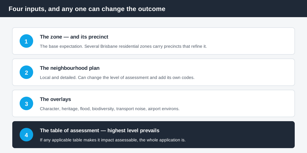
Figure 2: Check all four. Any one of them can change the outcome.
The zone. Brisbane maps residential zones including low density residential, low-medium density residential, medium density residential, high density residential, character residential and emerging community, alongside centre, mixed use, industry, recreation, environmental and rural zones. Several carry precincts that refine the expectation further.
The neighbourhood plan. These are local and detailed, and they can change both the level of assessment and the benchmarks.
The overlays. A single overlay can turn something accepted into something assessable. Brisbane owners most often encounter the traditional building character overlay, the heritage overlay, the flood overlay, biodiversity and waterway overlays, transport noise corridor mapping and the airport environs provisions.
The table of assessment. This is where the other three are converted into an answer.
How to read a table of assessment
The tables specify, for each type of development, the level of assessment and the applicable codes. There are separate tables for zones, for neighbourhood plans and for overlays.
The levels are the ones set by the Planning Act 2016: accepted development, sometimes subject to requirements; code assessment, where the application is assessed only against the relevant codes; and impact assessment, where it is assessed against the whole planning scheme to the extent relevant and must be publicly notified. Accepted versus assessable development in QLD sets out what each means for time, cost and appeal rights.
The reading order that works:
- ✓Find the zone, neighbourhood plan and overlays for the site.
- ✓Open the zone's table of assessment and find your development type. Read the row that matches your actual circumstances, since rows often differ by lot size, frontage or scale.
- ✓Note the level of assessment and every code listed.
- ✓Open the overlay and neighbourhood plan tables and check the same proposal there. They can raise the level of assessment and add codes.
- ✓The highest level of assessment prevails. If any applicable table makes it impact assessable, the whole application is impact assessable.
- ✓Assemble the full list of codes. That list is your assessment benchmarks.
- ✓What zone and precinct is the site in?
- ✓Is there a neighbourhood plan?
- ✓Which overlays apply?
- ✓What does each applicable table of assessment say?
- ✓What is the highest level of assessment across them?
Amendments and versions
City Plan has been amended many times since 2014, and it is amended on an ongoing basis. Amendments since the original version have covered neighbourhood plans and rezonings for growth areas, alignment with the regional plan, updates to residential zone provisions, and — significantly for many owners — successive updates to the flood overlay mapping and flood overlay code, including work following the 2022 flood event.
The practical implication is simple and important: a City Plan answer from two years ago may be wrong today. City Plan online carries the current version, an amendment history and the ability to view previous versions, and council's news and updates listing is the authoritative record of what has changed. Check the version before relying on anything, including on articles.
Looking up your property
City Plan online is the tool, and there are two doors into it: view planning scheme, which opens the scheme text, and view map, which opens the interactive mapping.
The efficient route for most people:
- ✓Open the map and search your street address or lot on plan.
- ✓Toggle the layers to see zones, overlays, neighbourhood plans and precincts.
- ✓Generate a property report for the site. This is the single most useful output — it summarises the zone, any neighbourhood plan and every overlay affecting the property, with links into the relevant codes.
- ✓From the report, open the zone code, overlay codes and neighbourhood plan code, then work through the tables of assessment.
Cross-check the same address on the Queensland Globe as well, which carries state layers that the council map does not. How to check overlays in QLD covers the mapping process in more detail.
What to do next
Get the property report first. It takes a minute and it prevents the most common mistake, which is reading the zone code for a property whose answer is actually driven by a neighbourhood plan or an overlay.
Then read the specific zone code for your site — the Low density residential zone explained and the Character residential zone explained cover the two that most Brisbane houses sit in.
If you'd rather see the zone, the overlays and the likely category of assessment for an address than work through a planning scheme yourself, an instantDA planning report does that for $169 — against the $800–$1,500 a town planner typically charges for a preliminary opinion. You can start a report in a few minutes.
Then confirm with council. Brisbane's duty planning service answers exactly these questions, and a scheme this large rewards a five-minute conversation about your specific address.
Frequently asked questions
What is Brisbane City Plan 2014?
How do I find out what my property is zoned in Brisbane?
What is a table of assessment?
What happens if the zone table and the overlay table say different things?
Does a neighbourhood plan override the zone?
How do I know I am reading the current version of City Plan?
Ready to generate your report?
Skip the writing. Get a council-ready planning report in 5 minutes.
Get your report