Key takeaways
- ✓One scheme covers the whole region: the Western Downs Planning Scheme 2017, incorporating Amendment 2, effective 28 July 2025.
- ✓The former Chinchilla, Dalby, Murilla, Tara, Wambo and Taroom shire schemes are superseded.
- ✓Council has no online lodgement portal. Applications go in by email, by post, or over the counter.
- ✓The Agricultural Land overlay is the constraint that most often decides what can happen on a Western Downs block.
- ✓Petroleum, gas and mining activities are assessed by the State, not by Council.
Do You Need Council Approval in Western Downs?
You'll usually hear this called a development application, or DA — that's the formal name for council approval under the Planning Act 2016. In the Western Downs, Council is the assessment manager for most of them, and the rules come from the Western Downs Planning Scheme 2017.
What makes this region different is that much of what happens on the ground here is not Council's to decide. Coal seam gas wells, pipelines and coal mines across the Surat Basin are assessed by the State. Council's scheme governs the rest — houses, sheds, subdivision, industry, and the workforce accommodation the gas industry brought with it.
Get a council-ready planning report in 5 minutes — no planner, no waiting.
Get your report →The short answer
You need a development application when the Western Downs Planning Scheme 2017 makes the work assessable for your zone and overlays. Much minor domestic work is accepted development. Building approval is separate and usually sits with a private certifier. Resource activities are assessed by the State.
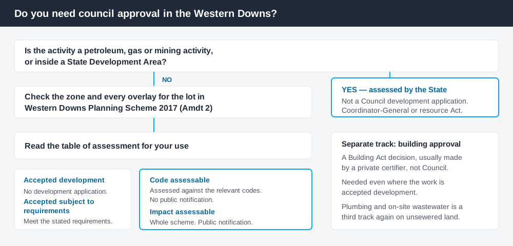
Figure 1: Three tracks run in parallel here. Answering one does not answer the others.
One scheme, six former shires
Western Downs Regional Council was formed from the Chinchilla, Dalby, Murilla, Tara, Wambo and Taroom shires, and for years afterwards those legacy schemes still applied in their old boundaries. Not any more. A single consolidated instrument now covers Dalby, Chinchilla, Miles, Tara, Wandoan and everything between: the Western Downs Planning Scheme 2017, which commenced on 20 March 2017.
The current version is the scheme incorporating Amendment 2, adopted under the Planning Act 2016 and effective from 28 July 2025, which brought in changes covering battery storage facilities, non-residential uses in the low density residential zone, secondary dwellings and craft breweries.
The old shires have not vanished from the paperwork: Council's fee register still carries separate infrastructure contribution rates for the Dalby, Tara, Chinchilla, Wambo, Murilla and Taroom areas, applying to approvals granted before 1 July 2011.
Like every Queensland scheme, this one follows the QPP structure — zone codes, overlay codes, tables of assessment — with Western Downs codes layered over it. Reading across from a neighbour will mislead you.
Two approval tracks, not one
Spend 5 minutes, not 3 weeks
instantDA generates a council-ready planning report for Queensland development applications. No town planner. No waiting.
Get your report →Development approval is a Planning Act 2016 decision. Council is the assessment manager, dealing with land use, siting, scale and compliance with the scheme's codes.
Building approval is a Building Act decision about whether the structure complies with the building assessment provisions, usually given by a private certifier. A farm shed can be accepted development under the scheme and still need building approval. Building approval versus development approval covers the distinction. Plumbing and on-site wastewater work adds a third track, which matters a great deal on unsewered land here.
- ✓What zone is the land in?
- ✓Which overlays touch it?
- ✓Accepted development or assessable?
- ✓Is building approval needed too?
- ✓Is on-site water and effluent disposal achievable?
- ✓Is a state-controlled road involved?
Checking your own address
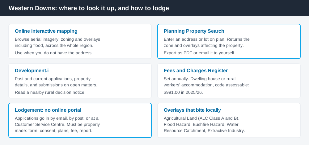
Figure 2: Four Council tools, each doing a different job.
Council runs an online mapping and planning property search. The interactive map shows aerial imagery, zoning and overlays including flood. If you have an address or a lot on plan, the Planning Property Search is faster — it returns the zone and overlays for the property, and exports as a PDF or an email.
Council also runs Development.i for past and current applications. On rural proposals especially, a recent decision notice tells you more about what Council will condition than the code text does. For state layers such as vegetation, cross-check on the Queensland Globe.
What catches Western Downs owners out
Agricultural land. This is the big one. The Agricultural Land overlay maps land classified ALC Class A and B, and the Natural Resources overlay code restricts what can be done on it. Reconfiguring a lot on Class A or B land in the Rural zone is directed away from creating lots under 500 hectares, and non-agricultural uses are steered off it unless the code lists them as acceptable. Building on rural land in Queensland covers the broader picture.
Workforce accommodation. Non-resident workforce accommodation is a use in its own right, and Council's 2025/26 fee register prices it accordingly: $23,059 under 30 beds, $69,162 for 30 to 300 beds, $172,914 above 300. Rural workers' accommodation is a separate and far cheaper proposition.
The Tara blocks. The rural subdivisions around Tara are unusual — roughly 2,000 lots, mostly about 10 to 40 hectares, largely without reticulated water, sewerage or power. They are not small blocks; they are ordinary rural lots with no services. The scheme's requirement that a lot contain an area capable of safe and efficient on-site water supply and wastewater disposal governs whether a dwelling works there. The Rural residential zone explained covers those zones and precincts.
State referrals. A proposal affecting a state-controlled road such as the Warrego or Moonie Highway goes to SARA. How SARA referrals work explains the timing.
When you will probably need a DA
Changing the use of land, adding a dwelling, subdividing, building at industrial scale, or building on land carrying the Agricultural Land, Flood Hazard, Bushfire Hazard or Water Resource Catchment overlays will usually make the work assessable.
A dwelling house or modest shed on an unconstrained lot meeting the acceptable outcomes for its zone is more often accepted development. Council notes that building work failing those acceptable outcomes can become assessable — setbacks are the usual culprit.
What to do next
Run the Planning Property Search, list every overlay it returns, then read the table of assessment for the use you intend.
A properly made application needs the relevant DA form, owner's consent, plans, the fee, and a planning report or code assessment against the relevant benchmarks. There is no online lodgement service — applications go by email, by post, or at a Customer Service Centre. Current fees sit in the Fees and Charges Register; a code assessable material change of use for a dwelling house, caretaker's accommodation, dwelling unit or rural workers' accommodation is $991.00 in 2025/26, and figures reset each financial year.
If you'd rather see the zone, the overlays and the likely category of assessment for a Western Downs address in one place, an instantDA planning report does that for $169 — against the $800–$1,500 a town planner typically charges for a preliminary opinion. You can start a report in a few minutes. Then confirm with Council's planning team before you commission drawings.
Frequently asked questions
What is the planning scheme for Western Downs?
Do the old shire planning schemes still apply?
How do I lodge a development application with Western Downs Regional Council?
Does Council approve coal seam gas wells or coal mines?
Can I subdivide cropping land in the Western Downs?
How much does a development application cost in Western Downs?
Ready to generate your report?
Skip the writing. Get a council-ready planning report in 5 minutes.
Get your report