Key takeaways
- ✓Storm tide is ocean flooding driven by storm surge on top of the tide. It is a different hazard from riverine flooding and is mapped separately.
- ✓Two distinct coastal controls apply: erosion, dealt with through the erosion prone area, and inundation, dealt with through storm tide mapping.
- ✓The Coastal Protection and Management Act 1995 is the state framework, with the State Planning Policy coastal hazards interest flowing into planning schemes.
- ✓Coastal hazard overlays typically raise floor levels, push buildings landward, and restrict new lots in the highest risk areas.
- ✓Tidal works — jetties, seawalls, revetments, pontoons — are a separate approval with state involvement.
Storm Tide and Coastal Hazard Areas in QLD
You'll usually hear this called a development application, or DA — that's the formal name for council approval under the Planning Act 2016. On the Queensland coast, two mapped hazards sit over that question, and they are frequently confused with each other and with river flooding.
The confusion has consequences. A property can be well clear of any creek or river and still be in a storm tide inundation area. It can be outside the storm tide mapping entirely and still be in an erosion prone area where the constraint is not water in the house but land disappearing from under it.
Get a council-ready planning report in 5 minutes — no planner, no waiting.
Get your report →The short answer
A storm tide is ocean flooding — storm surge on top of the normal tide, often with wave setup. Queensland regulates coastal land for two separate hazards: erosion, through the erosion prone area, and inundation, through storm tide mapping. Councils apply both through a coastal hazard overlay.
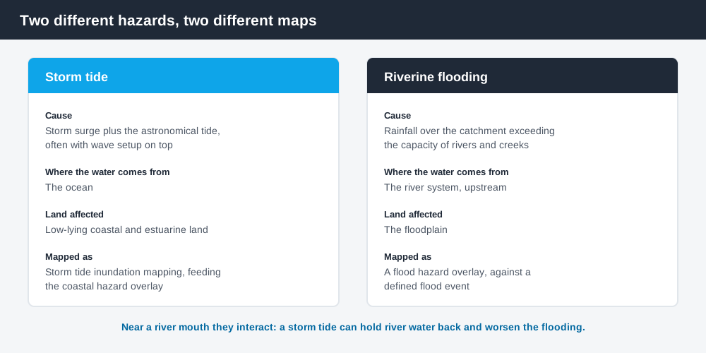
Figure 1: Different cause, different mapping, different overlay.
Storm tide is not river flooding
A storm tide is the total water level reached when a storm surge — the abnormal rise in sea level caused by severe weather, typically a tropical cyclone — combines with the normal astronomical tide, often with wave setup on top. The water comes from the ocean, it arrives quickly, and it inundates low-lying coastal and estuarine land.
Riverine flooding comes from rainfall over a catchment causing rivers and creeks to exceed their channels and spread across the floodplain. It travels through the river system, generally independent of the tide, though a storm tide can worsen flooding near a river mouth by holding water back.
They are mapped separately, assessed separately, and often produce different answers for the same lot. Flood hazard overlays in QLD covers the riverine side; the coastal hazard framework is what follows here.
The state framework
Spend 5 minutes, not 3 weeks
instantDA generates a council-ready planning report for Queensland development applications. No town planner. No waiting.
Get your report →The Coastal Protection and Management Act 1995 is Queensland's principal statute for coastal management and protection. It underpins the declaration of the coastal management district — the mapped stretch of coast where coastal management provisions apply — and the regulation of tidal works.
The State Planning Policy carries a coastal hazards state interest that planning schemes must reflect. In substance it requires planning to avoid or minimise exposure of people and property to erosion and storm tide, to use coastal hazard mapping, and to control new development and reconfiguration of lots in high-risk areas.
Councils implement that through a coastal hazard overlay and an overlay code. That is where the requirements a landowner actually encounters live. Coastal hazard overlays in QLD covers how those codes are structured.
Erosion prone area
The erosion prone area is a mapped strip of coastal land assessed as vulnerable to erosion, recession and shoreline movement over a planning horizon, taking in both storm impact and longer-term shoreline change. It is expressed as an erosion prone area width measured landward from a reference line, and it is declared and mapped by the state department responsible for coastal management under the Coastal Protection and Management Act 1995.
Inside it, the usual consequences are:
- ✓new lots and new urban development are discouraged or restricted unless the risk can be adequately managed
- ✓buildings and structures are required to be set back landward of the mapped boundary
- ✓interference with dunes and beaches, and hard coastal protection works, are controlled and generally need approval
- ✓design responses such as relocatable or elevated structures, and no basements fronting the shoreline, appear in overlay codes
The point of an erosion prone area is not that the land is unusable today. It is that the shoreline is expected to move, and a building placed too far seaward becomes a problem for its owner and for the beach in front of it.
Storm tide inundation mapping
Storm tide inundation mapping identifies the areas that would be flooded by a specified storm tide event, commonly framed around a 1% annual exceedance probability level. The modelling accounts for storm surge and its interaction with tides, wave setup and nearshore water levels, local bathymetry and coastal shape, and cyclone characteristics.
That mapping does two jobs. It sets storm tide evacuation areas, which are an emergency management tool, and it feeds the planning scheme's coastal hazard overlay, which is a development control. The two use the same underlying science but answer different questions, and being in an evacuation area is not by itself a planning constraint.
What the overlay typically requires
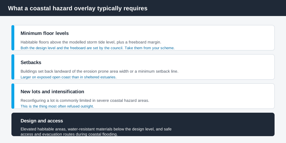
Figure 2: Typical pattern. The numbers are always council-specific.
Requirements vary between schemes, but the pattern is consistent:
Minimum floor levels. New habitable floors must sit above the modelled storm tide level, generally with a freeboard margin added. The design level and the freeboard are both set by the council, so take them from your scheme rather than from a figure in an article.
Setbacks. Buildings must be set back landward of the erosion prone area width or a minimum setback line, with larger setbacks on exposed open coast than in sheltered estuaries.
New lots and intensification. Reconfiguring a lot in severe coastal hazard areas is commonly limited, and applicants may need to demonstrate that each new lot has a safe, developable area outside the high-risk zone. Some schemes discourage new residential lots entirely in extreme erosion or storm tide areas.
Design and access. Elevating habitable areas, water-resistant materials below the design level, and safe access and evacuation routes during coastal flooding.
- ✓Is the lot in the coastal management district?
- ✓Is it in the erosion prone area, and what is the width?
- ✓Is it in the storm tide inundation mapping?
- ✓What floor level and freeboard does the overlay code require?
- ✓Do the works involve anything below high water?
Tidal works
If the project includes anything in or over tidal water — a jetty, pontoon, seawall, revetment, ramp, or dredging — that is tidal works, and it is a separate approval question with state involvement rather than something the council decides alone. Coastal impacts and effects on coastal processes are assessed against the state's coastal and tidal works requirements.
Confirm early who the assessment manager and any referral agencies are for your particular works, because it changes the timeline substantially and it is not obvious from the planning scheme alone.
Where to check
Start with the council. Many coastal councils publish storm tide maps, evacuation area maps and their coastal hazard overlay mapping directly, and the state's own environmental reporting notes that major regional centres vulnerable to storm tide inundation have mapping available through their regional council websites.
Cross-check on the Queensland Globe, which carries state layers including coastal management mapping, and check the planning scheme overlay maps rather than relying on the evacuation map, which is a different product. How to check overlays in QLD covers the mapping process.
What to do next
Establish three things before you buy or design: whether the lot is in the coastal management district, whether it is in the erosion prone area, and whether it is in the storm tide inundation mapping. They are separate questions and the answers do not follow from each other.
If you'd rather see the zone, the overlays and the likely category of assessment for an address than work through a planning scheme yourself, an instantDA planning report does that for $169 — against the $800–$1,500 a town planner typically charges for a preliminary opinion. You can start a report in a few minutes.
Then confirm with your council, and get the design storm tide level and required freeboard for your specific address in writing before your designer sets a floor level. Buying land to build on in QLD covers the wider pre-purchase check.
Frequently asked questions
What is a storm tide?
How is storm tide different from flooding?
What is an erosion prone area?
Can I build in a coastal hazard overlay in Queensland?
Do I need approval for a jetty or seawall?
Where do I check whether my property is affected?
Ready to generate your report?
Skip the writing. Get a council-ready planning report in 5 minutes.
Get your report