Key takeaways
- ✓The Vegetation Management Act 1999 regulates native vegetation clearing across all tenures in Queensland, not just rural leasehold.
- ✓Your lot's regulated vegetation management map categories — A, B, C, R or X — decide whether clearing is regulated at all.
- ✓Category X is the unregulated remainder. Everything else needs an exemption, an accepted development code, or a development approval.
- ✓State exemption from vegetation law does not clear you under a council biodiversity overlay, koala mapping, or a local vegetation protection instrument.
- ✓Download the free vegetation management property report for your lot on plan before you clear anything.
Vegetation Clearing Laws in QLD
You'll usually hear this called a development application, or DA — that's the formal name for council approval under the Planning Act 2016. Clearing native vegetation in Queensland is generally operational work under that Act, which means it can be prohibited, assessable, or allowed under a code, and which of those applies is decided by a map.
That map is the point. Two adjoining paddocks can carry entirely different clearing rights because one is mapped remnant and the other is not. Nothing about how the country looks on the ground tells you which is which.
Get a council-ready planning report in 5 minutes — no planner, no waiting.
Get your report →The short answer
The Vegetation Management Act 1999 regulates native vegetation clearing across all land tenures in Queensland. Your lot's regulated vegetation management map assigns categories — A, B, C, R or X. Category X is unregulated. Everything else needs an exemption, an accepted development code, or a development approval.
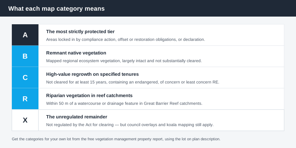
Figure 1: The category on your map, not the look of the vegetation, decides the rules.
The framework
The Vegetation Management Act 1999 is the statewide law regulating clearing of native vegetation across freehold, leasehold, Indigenous and unallocated state land. It is administered by the state department responsible for resources.
It does not operate alone. The Planning Act 2016 and the Planning Regulation 2017 make most native vegetation clearing either prohibited or assessable development, so a clearing job is lawful only where one of three things is true:
- ✓it falls within an exemption;
- ✓it complies with an accepted development vegetation clearing code or an area management plan; or
- ✓it holds a development approval.
Clearing outside those three is a development offence, and it is enforced.
What the categories mean
Spend 5 minutes, not 3 weeks
instantDA generates a council-ready planning report for Queensland development applications. No town planner. No waiting.
Get your report →Every lot carries a regulated vegetation management map, and the categories on it determine everything.
Category B is remnant native vegetation — mapped regional ecosystem vegetation that is largely intact and has not been substantially cleared. Clearing in Category B is tightly controlled.
Category C is high-value regrowth on specified tenures: native vegetation that has not been cleared for at least 15 years on freehold land, Indigenous land, and land under certain occupation licences or leases under the Land Act 1994, where the area contains an endangered, of concern or least concern regional ecosystem.
Category R is riparian vegetation in Great Barrier Reef catchments — native vegetation within 50 metres of a watercourse or drainage feature — reflecting its role in controlling sediment and nutrient runoff to the reef.
Category A is the most strictly protected tier, covering areas locked in by prior compliance action, offset or restoration obligations, or declaration.
Category X is the remainder: everything not A, B, C or R, commonly shown white on the map. Category X land is not regulated under the Vegetation Management Act for clearing, and can generally be cleared without a permit under that Act — subject to every other law that might apply.
Exemptions on freehold land
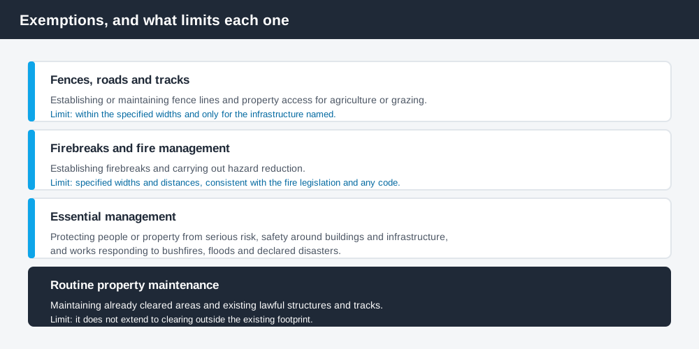
Figure 2: Each exemption has conditions and limits attached. None is open-ended.
A range of clearing is exempt, and these are the ones landholders rely on most:
Fences, roads and tracks. Clearing to establish or maintain fence lines and property access tracks for agriculture or grazing, within specified limits.
Firebreaks and fire management. Clearing to establish firebreaks and to carry out hazard reduction, within specified widths and distances and consistent with the fire legislation and any applicable code.
Essential management. Clearing to protect people or property from serious risk, to maintain safety around buildings and infrastructure, and works responding to bushfires, floods and declared disasters.
Routine property maintenance. Maintaining areas that are already cleared, and maintaining existing lawful structures and tracks — but not clearing remnant or regulated regrowth outside the existing footprint.
Further exemptions sit in other legislation, including the Forestry Act 1959 for certain forestry operations, the Fire and Emergency Services Act 1990 for authorised fire management, the Electricity Act 1994 for clearing around electricity infrastructure, and the Disaster Management Act 2003 for declared disasters.
One trap worth naming: the Nature Conservation Act 1992 can require a protected plant clearing permit even where the clearing is otherwise exempt, unless a specific protected plant exemption applies.
- ✓What categories are on the property map?
- ✓Does an exemption cover the work, on its own terms?
- ✓Is there an accepted development clearing code that fits?
- ✓Is the lot in mapped koala habitat?
- ✓Does the council scheme carry a biodiversity overlay here?
Accepted development codes and area management plans
For lower-risk clearing, the framework provides accepted development vegetation clearing codes — covering activities such as managing weeds or encroachment and certain fire management work — and area management plans, which set localised rules for particular regions or issues.
Working under a code means no development approval is needed, but the code's conditions are binding and often include notification, mapping and record-keeping obligations. Codes are also revoked and replaced over time: some clearing that was accepted development under an earlier code now requires a development approval. Check the current code rather than relying on what applied a few years ago.
Councils regulate vegetation too
State exemption is not the whole answer. Local governments regulate vegetation independently through:
Biodiversity or environmental overlays in the planning scheme, which can make clearing or development assessable even where the Vegetation Management Act does not regulate the vegetation at all. Biodiversity overlays in QLD covers how those codes work.
Local laws and vegetation protection instruments protecting particular trees, roadside vegetation, corridors or bushland, with their own approval requirement and penalties.
In south east Queensland there is a third layer: mapped koala habitat carries state-level controls that are separate again from the Vegetation Management Act, though clearing carried out in accordance with an applicable vegetation clearing code can be relevant to them. Koala habitat areas and QLD development covers that framework.
Clearing for bushfire protection sits at the intersection of two of these, and needs to satisfy both — bushfire hazard overlays in QLD covers the hazard side.
How to check your property
Download the free vegetation management property report from the Queensland Government by entering your lot on plan description. It returns the regulated vegetation categories for your land along with the other layers you need to work out clearing requirements.
Cross-check the same lot on the Queensland Globe, which carries the regulated vegetation management map alongside other state layers. Then check your council's planning scheme mapping for biodiversity or environmental overlays, because those will not appear on the state report.
What to do next
Get the property report before you commit to a house site, a shed location, a new track or a clearing program. It is free, it takes minutes, and it is the difference between a lawful job and a prosecution.
If the work is more than an obvious exemption, get the position in writing — either from the state department's vegetation management service, or through a development application. Building on rural land in QLD covers how vegetation interacts with siting a house.
If you'd rather see the zone, the overlays and the likely category of assessment for an address than work through a planning scheme yourself, an instantDA planning report does that for $169 — against the $800–$1,500 a town planner typically charges for a preliminary opinion. You can start a report in a few minutes.
Then confirm with your council for the local overlay layer, which the state report does not cover.
Frequently asked questions
What does the Vegetation Management Act 1999 regulate?
What does Category X mean on my vegetation map?
What is Category C vegetation?
Can I clear for a firebreak without approval?
Do council rules apply as well as the state law?
How do I find out what's on my property?
Ready to generate your report?
Skip the writing. Get a council-ready planning report in 5 minutes.
Get your report