Key takeaways
- ✓A waterway corridor or wetland overlay does not ban building. It usually raises the category of assessment and pushes development away from the watercourse.
- ✓The mapping behind these overlays comes from the State Planning Policy, layered on top of statewide wetland and water quality mapping.
- ✓Buffer widths are set by each council's overlay code, not by the state. They are not uniform across Queensland.
- ✓Work in a watercourse, lake or spring can need a separate riverine protection permit under the Water Act 2000, on top of any council approval.
- ✓Check the council's own overlay mapping first, then the state mapping, and confirm anything marginal with the council before you design.
Waterway Corridor and Wetland Overlays in QLD: What They Mean
You'll usually hear this called a development application, or DA — that's the formal name for council approval under the Planning Act 2016. An overlay does not create a DA on its own. What it does is flag that your land carries a constraint the planning scheme wants considered, and it can change how your proposal is assessed.
Waterway corridor and wetland overlays are among the most consequential of those flags, because they can move a project from something you simply build to something a council assesses against an environmental code.
Get a council-ready planning report in 5 minutes — no planner, no waiting.
Get your report →The short answer
A waterway corridor or wetland overlay identifies land near a watercourse or wetland where development is managed to protect water quality and habitat. It rarely prohibits building. It usually raises the category of assessment, pushes structures back from the water, and controls clearing and earthworks within the mapped area.
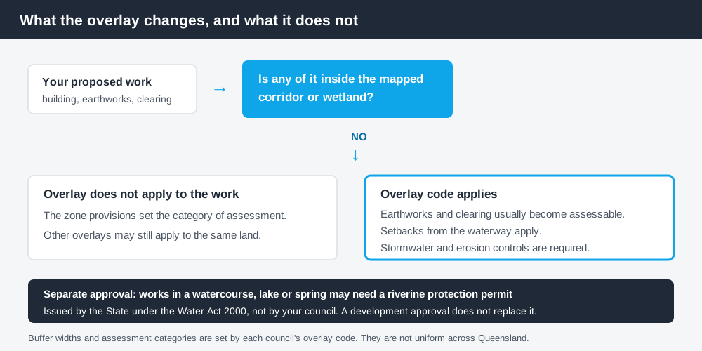
Figure 1: What the overlay changes, and what it does not.
What the overlay actually does
In a Queensland planning scheme, the zone tells you the intended use of the land. An overlay sits on top of the zone and identifies a characteristic that needs managing — a hazard, a resource, or an environmental value. Where the two disagree about the category of assessment, the overlay generally prevails.
For a waterway corridor or wetland overlay, that usually plays out in three ways.
- ✓Operational work such as earthworks or clearing inside the mapped corridor becomes assessable
- ✓Buildings and structures must be set back from the waterway or wetland
- ✓Stormwater and erosion controls have to meet water quality outcomes
Redland City Council's waterway corridors and wetlands overlay is a fair example of the pattern. It maps existing waterway corridors and wetlands across the local government area, with the stated purpose of managing development so it avoids significant impacts on matters of national, state and local environmental significance. Clearing only needs a development approval where the vegetation is also caught by the council's environmental significance overlay — which is exactly the kind of council-specific interaction that makes reading your own scheme unavoidable.
Where the mapping comes from
Spend 5 minutes, not 3 weeks
instantDA generates a council-ready planning report for Queensland development applications. No town planner. No waiting.
Get your report →Councils do not invent this mapping from nothing. Most of it traces back to the State Planning Policy, which is made under the Planning Act 2016 and sets the state interests that every planning scheme has to reflect. Two of those state interests matter here: water quality and biodiversity.
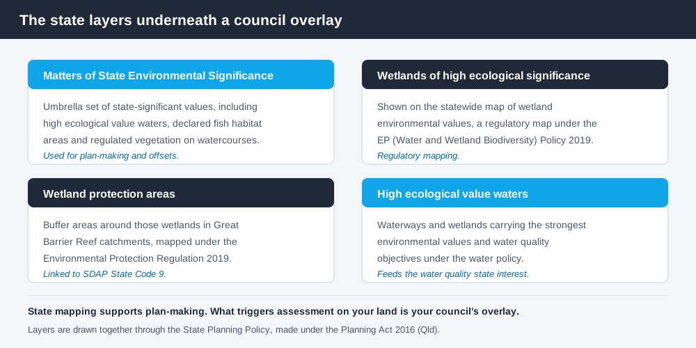
Figure 2: The state layers that sit underneath a council overlay.
Sitting under those interests are several statewide datasets.
Matters of State Environmental Significance (MSES) is the umbrella term for state-significant environmental values used in planning and in the environmental offsets framework. It pulls together values protected across a range of Queensland legislation — protected areas, declared fish habitat areas, regulated vegetation intersecting watercourses, high ecological value waters, and wetlands.
Wetlands of high ecological significance (HES) are identified on the statewide map of wetland environmental values, a regulatory map made under the Environmental Protection (Water and Wetland Biodiversity) Policy 2019. You can read the Queensland Government's explanation of the referrable wetland mapping directly.
Wetland protection areas (WPAs) are buffer areas around HES wetlands in Great Barrier Reef catchments, mapped under the Environmental Protection Regulation 2019. Development in a WPA can be assessed against State Code 9 of the State Development Assessment Provisions, which deals specifically with Great Barrier Reef wetland protection areas.
One caution worth holding on to: MSES mapping is prepared to support plan-making and offsets. It is not, by itself, a development assessment trigger. The thing that triggers assessment on your land is the overlay in your council's planning scheme, which may or may not match the state layer exactly.
Why buffer widths are not uniform
There is no statewide setback from a waterway. Each council writes its own overlay code, and the numbers vary with the zone, the lot size, the type of development and the ecological value of the particular waterway.
Queensland's planning schemes follow the Queensland Planning Provisions structure, but each council layers its own codes, overlay maps and buffer distances on top. They are not uniform. Broadly, you will see wider buffers where the waterway is intact, steep or carries a high ecological value, and narrower buffers in established urban areas where engineered stormwater treatment does more of the work. Treat any figure you find on a general website as an indication only and read the actual overlay code for your council.
Because overlays interact, this is rarely the only constraint. A riparian corridor frequently overlaps with flood mapping and with vegetation controls, and each brings its own code. Working through how to check which overlays apply to your property before you commission drawings will usually save a redesign.
The Water Act permit councils cannot give you
This is the part people miss. Council approval and state water approval are separate systems.
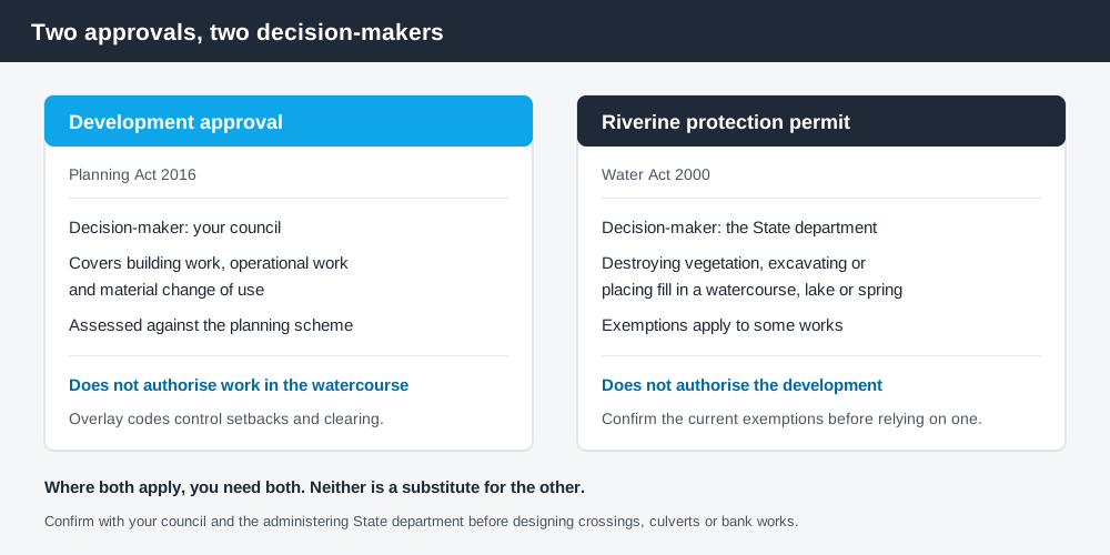
Figure 3: Two approvals, two decision-makers, no substitute for each other.
Under the Water Act 2000, destroying vegetation, excavating, or placing fill in a watercourse, lake or spring can require a riverine protection permit, issued by the state department that administers that Act rather than by your council. Exemptions exist for certain works, and the detail sits in the Act and its regulation.
The important point is structural: a development approval under the Planning Act 2016 does not authorise riverine works, and a riverine protection permit does not authorise development. Where both apply, you need both. If your project involves a crossing, a culvert, bank stabilisation or fill anywhere near a defined watercourse, ask the question early — confirm the position with your council and the state department rather than assuming the DA covers it.
How to check your own property
Start with the council, because the council overlay is what regulates you. Nearly every Queensland council publishes interactive planning scheme mapping and, in most cases, a downloadable property or parcel report that lists the zone and every overlay affecting the land.
Then cross-check the state layers. Queensland Globe will confirm the correct lot on plan and show a wide range of state datasets, and the WetlandInfo guidance on state regulation and planning explains which wetland maps carry statutory weight and which are advisory.
Where the mapping clips only part of your lot — which is common with a corridor that follows a creek line — the overlay may affect the rear of the property and leave the building envelope untouched. That is a good outcome, but it is worth confirming in writing rather than reading off a screen.
What to do next
If your land is mapped, the practical sequence is: identify which overlay code applies, find the buffer and the category of assessment for the work you want to do, then design the building envelope outside the corridor if you can. Most projects that fail here fail because the siting was fixed before the constraint was understood.
If you'd rather see your zone, your overlays and your likely category of assessment set out in one document than work through a planning scheme yourself, an instantDA planning report does that for your address for $169 — against the $800–$1,500 a town planner typically charges for a preliminary opinion. You can start a report in a few minutes.
Because waterway mapping so often travels with habitat mapping, the biodiversity overlay in QLD is usually the next thing to read, and it explains how offsets work if an impact cannot be avoided. If your plans involve removing trees along the bank, vegetation management in QLD covers the separate clearing rules that apply. And if the corridor follows a creek that floods, the flood hazard overlay in QLD will tell you what else is likely to be triggered.
Then confirm the position with your council before you spend money on design. Overlay questions are cheap to ask and expensive to discover late.
Frequently asked questions
What is a waterway corridor overlay in Queensland?
Can I build on a property with a wetland overlay in QLD?
How far do I have to build from a creek in Queensland?
Do I need a permit to work in a creek in Queensland?
What are matters of state environmental significance?
How do I find out if my property has a waterway overlay?
Ready to generate your report?
Skip the writing. Get a council-ready planning report in 5 minutes.
Get your report