Key takeaways
- ✓Bulloo runs the Bulloo Shire Planning Scheme, gazetted in January 2019 and commenced on 1 February 2019.
- ✓There are six zones and no overlay codes at all — flood comes from the scheme's own Schedule 2 flood mapping.
- ✓Thargomindah's 2025 Bulloo River flood broke the 1974 record and overtopped the town levee.
- ✓There is no online lodgement portal: applications go to Council by email, post or over the counter.
- ✓Lodgement fees are modest, but Council charges external consultant assessment costs on top, at cost.
Do You Need Council Approval in Bulloo Shire?
You'll usually hear this called a development application, or DA — that's the formal name for council approval under the Planning Act 2016. In Bulloo, Council is the assessment manager, and the rules it applies come from the Bulloo Shire Planning Scheme.
Bulloo is the far south-west corner of Queensland: roughly 73,600 square kilometres of Channel Country, a few hundred residents, and three small settlements — Thargomindah, Hungerford on the southern border, and Noccundra. Everything else is grazing country, oil and gas, and floodplain.
Get a council-ready planning report in 5 minutes — no planner, no waiting.
Get your report →The short answer
In Bulloo Shire you need a development application when the Bulloo Shire Planning Scheme makes the work assessable for your zone. Sheds, carports and decks usually need building approval only. Flood mapping is what most often turns a no into a yes, so check it first.
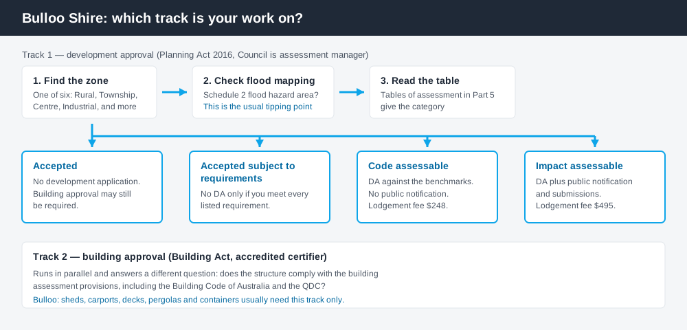
Figure 1: Two tracks run in parallel. Answering one does not answer the other.
The Bulloo Shire Planning Scheme
The scheme may be cited simply as the Bulloo Shire Planning Scheme. A notice appeared in the Government Gazette on 25 January 2019 and the commencement date was 1 February 2019; Council's own planning pages refer to it as the Bulloo Shire Planning Scheme 2019.
It follows the standardised structure used across Queensland — strategic framework, tables of assessment, zones, codes — but Queensland schemes share that structure, not their content, and this one is small. There are six zones: Recreation and open space, Rural, General residential, Centre, Industrial and Township. A handful of codes carry the rest, including a General development code, an Operational works code, a Reconfiguring a lot code, and — telling you a lot about the local economy — a Non-resident workforce accommodation code for camps serving the oil and gas fields.
Understanding which zone your property is in is the first step in reading any of it.
No overlay codes — the constraints sit in the mapping
Spend 5 minutes, not 3 weeks
instantDA generates a council-ready planning report for Queensland development applications. No town planner. No waiting.
Get your report →The scheme has no overlay codes. Where a city scheme would send you to a flood or bushfire overlay, Bulloo's tables of assessment point straight at maps.
Flood runs through the scheme's own Schedule 2 – Flood mapping. Read the material change of use tables and one phrase repeats: a use is accepted development only where it is not located in a flood hazard area shown on Schedule 2 – flood mapping. Being inside that mapped area is frequently the single fact that moves work from needing nothing to needing a DA.
Bushfire works differently again. The scheme sends you to state planning policy mapping for natural hazards rather than a council layer. Flood hazard overlays and bushfire hazard overlays explain how those layers behave in practice.
Two approval tracks, not one
Development approval is a Planning Act 2016 decision made by Council as assessment manager. It deals with land use, siting, scale and compliance with the scheme's codes.
Building approval is a Building Act decision about whether the structure complies with the building assessment provisions, including the Building Code of Australia and the Queensland Development Code. It is given by an accredited certifier — Council or a private one.
Council states the distinction unusually plainly: sheds, garages, carports, patios, decks, pergolas and shipping containers require building permits but do not generally require a development application. That is the opposite of what many owners assume. Building approval versus development approval covers where the line falls.
- ✓Which of the six zones?
- ✓Flood hazard area on Schedule 2?
- ✓Bushfire prone on state mapping?
- ✓Accepted, or assessable?
- ✓Building approval as well?
- ✓Consultant assessment costs?
Checking your own address
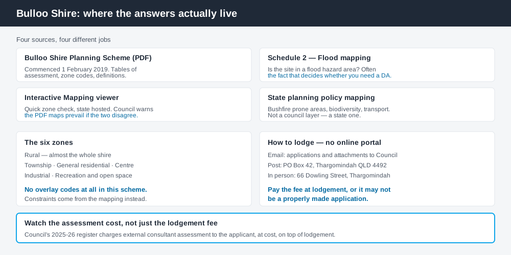
Figure 2: What Bulloo publishes, and what each source is actually for.
Council links Bulloo Planning Scheme Interactive Mapping, a state-hosted viewer, from its Planning pages. Read Council's warning before you rely on it: the interactive mapping does not replace the PDF scheme maps, and where the two disagree, the PDF maps prevail. Council also directs owners to the zoning maps for Thargomindah, Hungerford and Noccundra inside the scheme document itself.
For state layers — vegetation, biodiversity, transport corridors — cross-check the site on the Queensland Globe.
What catches Bulloo owners out
Flood, above everything. The scheme's own strategic framework records major Bulloo River events in 1918, 1954, 1991, 2011 and 2016, notes a catchment of about 74,900 square kilometres, and observes that floods forming in the headwaters near Adavale give up to seven days of warning. Then came 2025: the Bulloo River at Thargomindah passed the 1974 record by close to a metre, the town's levee was overtopped, and essentially the whole population was evacuated. Assume flood mapping is live for your site until you have checked it.
Rural does not mean unregulated. Nearly all the shire is Rural zone. Reconfiguring a lot, operational work such as earthworks, and intensive or extractive uses all engage the scheme. Building on rural land covers the pattern.
Assessment costs are open-ended. Council's adopted 2025–26 fees list lodgement fees of $248.00 for a code assessable material change of use and $495.00 for an impact assessable one — but the register also states that the cost of assessment by external consultants is paid by the applicant, at cost. The lodgement fee is not the bill.
When you will probably need a DA
Work that starts a new use, increases the intensity of an existing one, subdivides or realigns boundaries, alters the shape of the land, or sits in a mapped flood hazard area is likely to be assessable. Worker accommodation, tourism uses and extractive industry are the live categories here. Modest work in town on an unconstrained lot is far more often accepted development, subject to requirements.
What to do next
Get the zone from Council's interactive mapping, confirm it against the PDF zoning maps, then check Schedule 2 flood mapping for the same address.
If you'd rather see the zone, the mapped constraints and the likely category of assessment for a Bulloo address in one place, an instantDA planning report does that for $169 — against the $800–$1,500 a town planner typically charges for a preliminary opinion. You can start a report in a few minutes.
Then contact Council. There is no online lodgement portal in Bulloo: applications are lodged by email, by post to PO Box 42, or in person at 66 Dowling Street, Thargomindah. Council's Lodging an Application page has the current details and warns that an application missing information may not be properly made.
Frequently asked questions
What is Bulloo Shire's planning scheme?
Does Bulloo Shire have online planning maps?
How much does a development application cost in Bulloo?
Are there overlays in the Bulloo planning scheme?
Do I need a DA for a shed in Thargomindah?
Ready to generate your report?
Skip the writing. Get a council-ready planning report in 5 minutes.
Get your report