Key takeaways
- ✓Bundaberg's scheme is the Bundaberg Regional Council Planning Scheme 2015, currently Version 6.5, effective 10 April 2026.
- ✓Council's Interactive Mapping generates a 2015 Adopted Planning Scheme Parcel Report showing your zone and overlays.
- ✓Defined flood levels across the region are anchored to the January 2013 Burnett River flood.
- ✓The Agricultural land overlay protects ALC Class A and Class B cane country from fragmentation.
- ✓Development approval and building approval are separate. A private certifier usually decides the second.
Do You Need Council Approval in Bundaberg?
You'll usually hear this called a development application, or DA — that's the formal name for council approval under the Planning Act 2016. In Bundaberg, Council is the assessment manager for most of them, and the rules it applies come from the Bundaberg Regional Council Planning Scheme 2015.
What makes Bundaberg distinctive is the weight its constraint mapping carries: a river that flooded catastrophically inside living memory, a coastline with erosion prone area mapping, and a sugarcane belt the scheme actively protects from being carved up. In much of the region, the overlay decides the answer before the zone gets a look in.
Get a council-ready planning report in 5 minutes — no planner, no waiting.
Get your report →The short answer
In Bundaberg, you need a development application when the Planning Scheme 2015 makes the work assessable for your zone and overlays. Plenty of minor domestic work is accepted development. Building approval is a separate decision, usually made by a private certifier rather than Council.
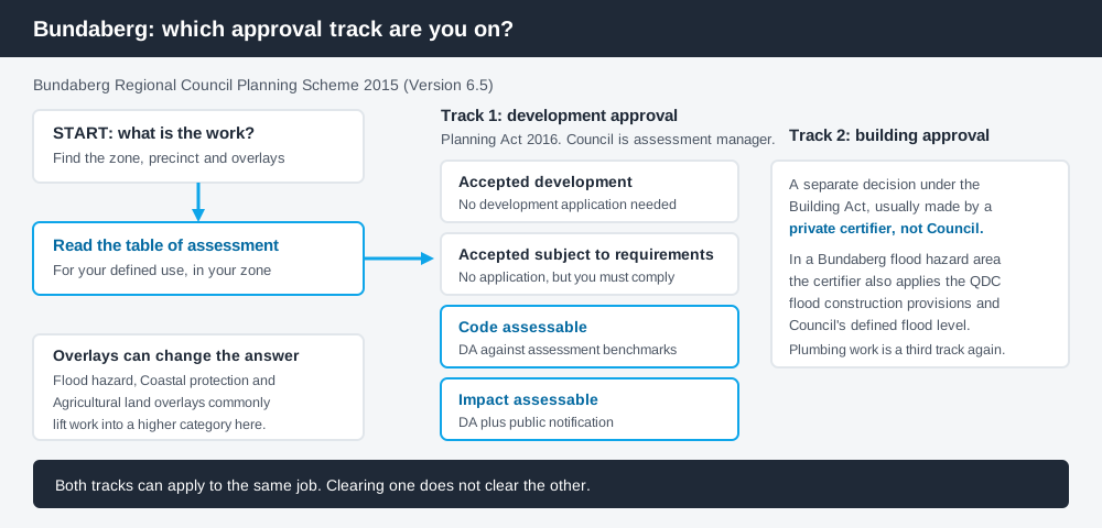
Figure 1: Two tracks run at once. Answering one does not answer the other.
The Bundaberg Regional Council Planning Scheme 2015
The scheme was originally made under the Sustainable Planning Act 2009, with Version 1.0 commencing on 19 October 2015, and has been amended steadily since rather than replaced. The current version is Version 6.5, adopted by Council at its meeting held 31 March 2026 and taking effect on and from 10 April 2026, incorporating an amendment to the Local Government Infrastructure Plan. Take your position from the current published version, not a saved PDF.
It follows the standardised Queensland structure — a strategic framework, zone codes, overlay codes, and tables of assessment — but the codes layered into it are Bundaberg's own. Queensland schemes are far less uniform than people assume, so a rule you read about another council does not transfer. What zone your property is in covers reading that structure.
Two approval tracks, not one
Spend 5 minutes, not 3 weeks
instantDA generates a council-ready planning report for Queensland development applications. No town planner. No waiting.
Get your report →This distinction resolves most of the confusion homeowners bring to Council.
Development approval is a Planning Act 2016 decision, with Council as assessment manager. It deals with land use, siting, scale and compliance with the scheme's codes.
Building approval is a Building Act decision about whether the structure complies with the building assessment provisions. It is usually given by a private certifier, not Council.
They are separate approvals under separate legislation with separate decision-makers. A shed can be accepted development and still need building approval, and a building approval does not cure a missing development approval. Building approval versus development approval covers this in full.
In Bundaberg the two tracks meet in one place. Council adopted flood hazard areas for the purposes of the Building Regulation 2021 by resolution in November 2025, effective 2 January 2026. Inside one, your certifier applies the Queensland Development Code provisions for construction in flood hazard areas against Council's declared defined flood level — a building decision driven entirely by planning mapping.
- ✓What zone applies?
- ✓Which overlays touch the lot?
- ✓Accepted, or assessable?
- ✓If accepted, is it accepted subject to requirements?
- ✓Do you need building approval too?
- ✓Is there a defined flood level?
Checking your own Bundaberg address
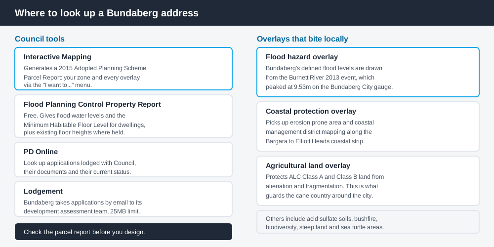
Figure 2: Four Council tools, each answering a different question.
Council's Interactive Mapping is the starting point. Search the address, then use the "I want to..." menu to generate a 2015 Adopted Planning Scheme Parcel Report, which pulls the zoning and overlays for your parcel into one document — what you need before reading any table of assessment.
Council also offers a free Flood Planning Control Property Report from the same site. It gives flood water levels across the events making up Council's Flood Hazard Area and states the Minimum Habitable Floor Level for dwellings. Near the Burnett, generate it before you brief a designer.
PD Online lets you look up applications lodged with Council and see where each sits in assessment. What has been approved nearby tells you what Council accepts in practice. Bundaberg's team takes applications by email, subject to a 25MB limit.
What catches Bundaberg owners out
Flood, and the 2013 benchmark. In January 2013, ex-Tropical Cyclone Oswald drove the Burnett River to 9.53 metres at the Bundaberg City gauge — the largest flood in the city's recorded history — inundating North Bundaberg and communities along the Burnett, Kolan and Baffle systems. That event still sets the defined flood levels used in assessment. Owners in Bundaberg North and Bundaberg East regularly find that a floor level, not a planning rule, constrains their design. The flood hazard overlay explained covers these.
Coastal mapping along the Coral Coast. The Coastal protection overlay picks up erosion prone area and coastal management district mapping through the Bargara, Elliott Heads and Moore Park strip, and buyers drawn by a beachfront position are often surprised how far inland it reaches. Coastal hazard overlays sets out the logic.
Cane land. The Agricultural land overlay protects Agricultural Land Classification Class A and Class B land from alienation, fragmentation and diminished productivity, and buffers farming from sensitive uses. Around Bundaberg that means cane country, where subdividing or building a house is not a formality. Building on rural land covers the pattern.
When you will probably need a DA
Work that changes the use of a property, adds a dwelling, reconfigures a lot, sits in the flood hazard, coastal protection or agricultural land overlays, or exceeds the thresholds in the applicable code is likely to be assessable. Minor domestic work on an unconstrained suburban lot is far more often accepted development.
Council fees are set annually. The 2026/2027 Fees and Charges Register, effective 1 July 2026, sets the fee for a code assessable material change of use for a dwelling house, dwelling unit or secondary dwelling at $1,355.00. Check the current fees and charges register for your own application type, as these move each year.
What to do next
Generate the parcel report for your address, add the Flood Planning Control Property Report if you are near a watercourse, then read the table of assessment for what you intend to build.
If you would rather see the zone, the overlays and the likely category of assessment for a Bundaberg address in one place, an instantDA planning report does that for $169 — against the $800–$1,500 a town planner typically charges for a preliminary opinion. You can start a report in a few minutes.
Then confirm with Council. For anything touching flood, coastal or agricultural land, have that conversation early — those overlays reshape designs rather than just adding conditions.
Frequently asked questions
What is Bundaberg's planning scheme called?
How do I check the zoning of a Bundaberg property?
Do I need council approval in Bundaberg for a shed or deck?
How do I find out my flood level in Bundaberg?
How is a development application lodged with Bundaberg Regional Council?
Ready to generate your report?
Skip the writing. Get a council-ready planning report in 5 minutes.
Get your report