Key takeaways
- ✓Cairns runs on CairnsPlan 2016 Version 3.1, adopted 13 July 2022 and commenced on and from 2 August 2022.
- ✓The CairnsPlan Property Report tool returns the zone, local plans and overlays for a single address.
- ✓Development approval and building approval are separate. A private certifier usually decides the building side.
- ✓Coastal processes, flood and inundation, hillslopes, acid sulfate soils and airport environs are the overlays that bite hardest in Cairns.
- ✓Council runs an Express DA service that decides eligible low-complexity applications in ten business days with a 20 per cent fee discount.
Do You Need Council Approval in Cairns?
You'll usually hear this called a development application, or DA — that's the formal name for council approval under the Planning Act 2016. In Cairns, Cairns Regional Council is the assessment manager for most of them, and the rules it applies come from CairnsPlan 2016.
What makes Cairns unusual is the number of natural constraints stacked on a narrow coastal strip, between the ranges and the sea, with the Wet Tropics World Heritage Area behind and the Great Barrier Reef World Heritage Area in front. On many Cairns lots the zone is the least interesting thing about the site.
Get a council-ready planning report in 5 minutes — no planner, no waiting.
Get your report →The short answer
In Cairns you need a development application when CairnsPlan 2016 makes the work assessable for your zone and overlays. Plenty of minor domestic work is accepted development. Building approval is a separate decision, usually made by a private certifier rather than by Council.
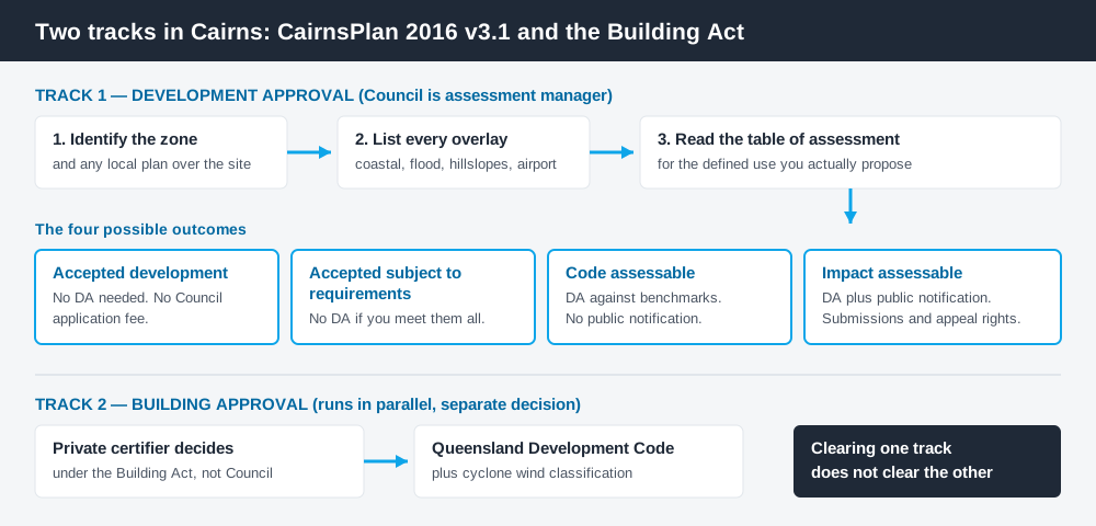
Figure 1: Two tracks run side by side. Clearing one does not clear the other.
CairnsPlan 2016 Version 3.1
Cairns Regional Council's planning scheme is CairnsPlan 2016. The current version is Version 3.1, adopted on 13 July 2022 and commenced on and from 2 August 2022. Earlier versions remain published as superseded schemes, so check the version stamp on any document before you rely on it.
CairnsPlan follows the standard Queensland structure — a strategic framework, zone codes, local plans, overlay codes, and tables of assessment setting the category of assessment for a defined use. But Queensland schemes are far less standardised than that suggests. The structure is common; the codes, thresholds and overlay names inside it are Council's own. Reading a Brisbane or Townsville answer across to a Cairns site is a reliable way to get it wrong. Working out what zone your property is in covers that structure.
Two approval tracks, not one
Spend 5 minutes, not 3 weeks
instantDA generates a council-ready planning report for Queensland development applications. No town planner. No waiting.
Get your report →Development approval is a Planning Act 2016 decision. Council is the assessment manager, and it deals with land use, siting, scale, height and compliance with the assessment benchmarks in CairnsPlan.
Building approval is a Building Act decision about whether the structure complies with the building assessment provisions, including the Queensland Development Code. It is usually given by a private certifier, not by Council.
Different legislation, different decision-maker, different question. A patio can be accepted development under CairnsPlan and still need building approval, and holding a building approval does not cure a missing development approval. Building approval versus development approval sets out the distinction properly.
Note too that "accepted development" and "accepted subject to requirements" are not the same thing. The second carries conditions you must meet, and Council charges a fee to confirm you have met them.
- ✓What zone applies?
- ✓Is a local plan over it?
- ✓Which overlays are mapped?
- ✓Is the work accepted, accepted subject to requirements, code assessable or impact assessable?
- ✓Do you also need building approval?
Checking your own address
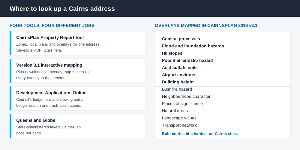
Figure 2: Four tools, four different jobs.
Council's CairnsPlan Property Report tool is the fastest starting point. Enter an address and it returns the applicable zones, local plans and overlays, with a PDF you can save or share. Council also publishes Version 3.1 interactive mapping and downloadable overlay map sheets.
Alongside that, Development Applications Online is Council's lodgement and viewing portal, where you can lodge, search and track applications made against the Cairns planning scheme. What has already been approved nearby tells you what Council genuinely accepts and what conditions it attaches — usually more useful than reading the code cold.
For state-administered layers, cross-check the site on the Queensland Globe, which carries information CairnsPlan does not.
What catches Cairns owners out
Storm tide and flood. Cairns is one of the most storm-tide-exposed cities in Australia. CairnsPlan maps both a Coastal processes overlay and a Flood and inundation hazards overlay, and between them they drive floor levels, building form and, for some work, the category of assessment. Storm tide and coastal hazard in Queensland explains how these controls behave.
Cyclone. Cyclone resistance sits on the building side, not the planning scheme — wind classification, tie-downs and glazing under the Building Act and the Queensland Development Code. A certifier conversation, not a DA one, but it shapes what your design can affordably be.
Hillslopes and landslip. The suburbs climbing the range behind the city carry a Hillslopes overlay and a Potential landslip hazard overlay, which commonly turn an ordinary house or retaining wall into assessable work needing geotechnical input.
Acid sulfate soils. Much of the coastal plain is mapped under an Acid sulfate soils overlay, which bites on excavation and fill rather than the building above. Acid sulfate soils in Queensland covers the triggers.
Airport environs and height. Cairns Airport sits close to the built-up area. The Airport environs overlay includes obstacle limitation surface mapping, and a separate Building height overlay applies. Height that would be uncontroversial elsewhere can be constrained here.
When you'll probably need a DA
Work that changes the use of a property, adds a dwelling, subdivides, exceeds a mapped height, disturbs soil in a hazard overlay, or sits in the Neighbourhood character or Places of significance overlays is likely to be assessable. Modest domestic work on an unconstrained suburban lot is far more often accepted development.
Council publishes a development assessment fee schedule set each financial year. As an anchor, the 2026/27 schedule sets the Category A small-scale material change of use fee — the category covering a dwelling house — at $1,135 where the application is code assessable. Fees change annually, so take the current figure from the schedule.
One local advantage: Council runs an Express DA service for low-complexity applications, decided within ten business days of lodgement and carrying a 20 per cent fee discount. It must be lodged by a Council-accredited consultant, so it is not a self-lodgement route.
What to do next
Generate the property report for your address, list every overlay it returns, then read the table of assessment for what you intend to build.
If you'd rather see the zone, the overlays and the likely category of assessment for a Cairns address in one place, an instantDA planning report does that for $169 — against the $800–$1,500 a town planner typically charges for a preliminary opinion. You can start a report in a few minutes.
Then confirm with Council. A free pre-lodgement enquiry is worth having before you engage a designer, particularly on anything touching hillslopes, storm tide or the airport surfaces. How to check overlays covers the groundwork first.
Frequently asked questions
What is the planning scheme for Cairns?
How do I check the zoning of a Cairns property?
Do I need council approval for a shed or patio in Cairns?
What is Express DA?
Is building approval the same as council approval?
Ready to generate your report?
Skip the writing. Get a council-ready planning report in 5 minutes.
Get your report