Key takeaways
- ✓The scheme is the Cook Shire Council Planning Scheme 2017, currently version 2.0, which commenced on 1 February 2017.
- ✓Eleven zones and eight overlay codes, including a Character overlay built around historic Cooktown and the waterfront.
- ✓Two local plans apply — Eastern Kuku Yalanji, with five precincts, and Lakeland.
- ✓There is no online lodgement portal. Applications go to Council by email, post or in person at Cooktown.
- ✓Council runs its own building certification service as well as accepting private certifier work.
Do You Need Council Approval in Cook Shire?
You'll usually hear this called a development application, or DA — that's the formal name for council approval under the Planning Act 2016. In Cook Shire, Council is the assessment manager, and the rules it applies come from the Cook Shire Council Planning Scheme 2017, currently version 2.0.
Cook Shire is the largest local government area in Queensland by land area — 106,169 square kilometres on Council's own figures, larger than Tasmania, on a rate base of roughly 2,200 properties. Over 90 per cent is national park, nature reserve, mining tenure, state land or reserve, and the shire holds two World Heritage Areas: the Wet Tropics of Queensland and the Great Barrier Reef.
In this guide: how the scheme is built, the two approval tracks, how to check an address, and what catches owners out on the Peninsula.
Get a council-ready planning report in 5 minutes — no planner, no waiting.
Get your report →The short answer
In Cook Shire you need a development application when the Cook Shire Council Planning Scheme 2017 makes your work assessable for that zone or overlay. Building work needs a separate building approval, from Council's own certifiers or a private certifier. There is no online lodgement portal — applications go to Council directly.
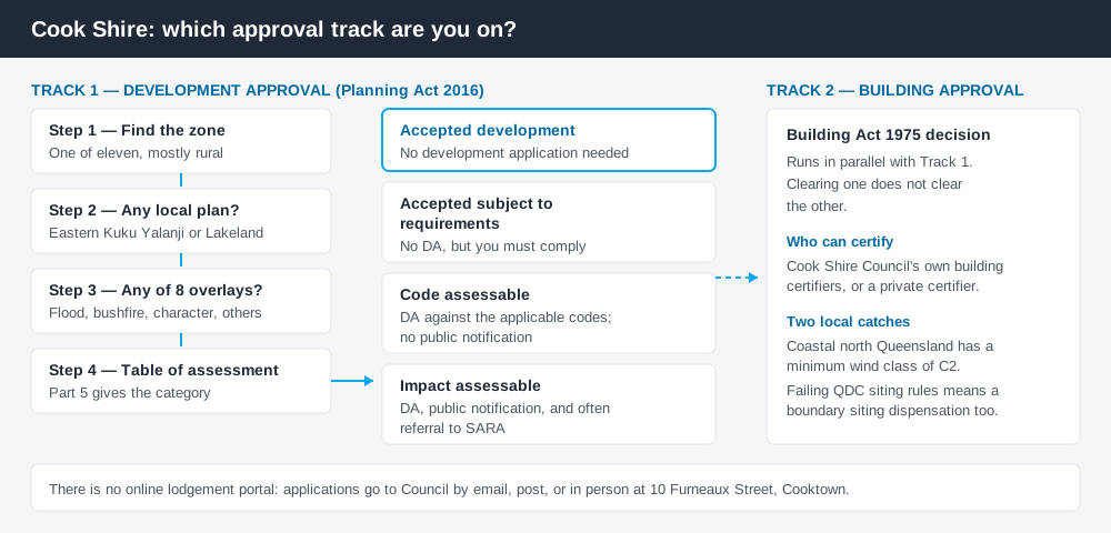
Figure 1: Two tracks run in parallel.
The Cook Shire Council Planning Scheme 2017
The scheme was gazetted by notice in Government Gazette No. 84 on 16 December 2016 and commenced on 1 February 2017. The document Council publishes is version 2.0, dated 25 November 2019.
It follows the standard Queensland structure — strategic framework, tables of assessment, zones, local plans, overlays, codes — but Queensland schemes share that structure, not their content. There are eleven zones: low density residential, medium density residential, centre, mixed use, township, industry, community facilities, rural residential, rural, recreation and open space, and environmental management and conservation. Almost all of the shire is rural or conservation.
Two local plans sit above the zones. The Eastern Kuku Yalanji Local Plan covers five precincts — Trevethan, Mungumby North, Little Annan, Mungumby South and Shipton's Flat — and where it applies, its provisions prevail over the rural zone code to the extent of any inconsistency. The Lakeland Local Plan covers the farming township on the Peninsula Developmental Road. Working out your zone is the first step, because a local plan can change the answer.
The overlays that actually bite
Spend 5 minutes, not 3 weeks
instantDA generates a council-ready planning report for Queensland development applications. No town planner. No waiting.
Get your report →Part 8 of the scheme carries eight overlay codes: airport environs, biodiversity, bushfire hazard, character, extractive resources, flood and other coastal hazards, scenic amenity, and landslide hazard.
Three are unusually live. The character overlay protects heritage places in historic Cooktown, and asks that new buildings on or adjoining the waterfront present well viewed from the water as well as from land. The flood and other coastal hazards overlay manages flood and erosion prone areas along a cyclone-exposed reef coastline. The extractive resources overlay protects named quarries and gravel pits — Bizant, Battle Camp Road, Violet Vale, Black Pinch — because road-base material is scarce and Council treats sterilising it as a road safety issue.
Bushfire hazard overlays and coastal hazard overlays explain how those layers change the category of assessment.
- ✓Which of the eleven zones?
- ✓Eastern Kuku Yalanji or Lakeland local plan?
- ✓Any of the eight overlays?
- ✓Accepted, or assessable?
- ✓Building approval as well?
- ✓State referral to SARA?
Two approval tracks, not one
Development approval is the Planning Act 2016 decision — land use, siting, scale, and compliance with the scheme's codes. Council is the assessment manager. Its guidance says a development application is likely if you want to use land for a new purpose such as a camping ground, workers' accommodation or machinery storage; reconfigure a lot; carry out operational work such as earthworks or fill; or build within certain overlays.
Building approval is a Building Act decision about the structure itself. Cook Shire still runs its own building certification service, assessing applications and carrying out mandatory inspections — you can use Council or a private certifier. Two practical points: coastal northern Queensland carries a minimum wind structural class of C2, and if a structure fails Queensland Development Code siting requirements, a boundary siting dispensation must be lodged too. Building approval versus development approval covers the distinction.
Checking your own address
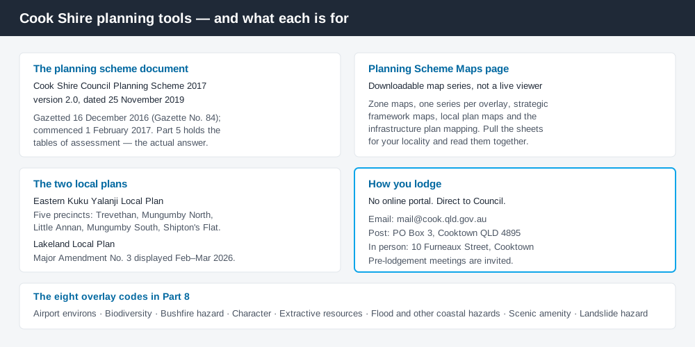
Figure 2: What Cook Shire publishes, and what each source is for.
Cook Shire does not run an interactive ePlan viewer. Its Planning Scheme Maps page publishes the map series as separate downloads — zone maps, a series for each overlay, strategic framework maps, local plan maps and infrastructure plan mapping. You pull the sheets covering your locality and read them together.
Lodgement is equally direct. There is no portal: applications go to Council by email at [email protected], by post to PO Box 3 Cooktown, or in person at 10 Furneaux Street, Cooktown. Council invites pre-lodgement meetings, which here is worth more than it sounds. For state layers, cross-check the site on the Queensland Globe.
What catches Cook Shire owners out
Seasonality. The scheme records cyclones and monsoon rains regularly cutting road access to parts of the shire for up to five months of the year — a programming problem, a supply problem, and for staged work a conditions problem.
Tenure. With more than 90 per cent of the shire in park, reserve, mining or state tenure, you are often not dealing with a simple freehold lot. Confirm tenure before you spend anything.
Remote servicing. Away from the townships there is no reticulated infrastructure, so water, power and effluent disposal have to be resolved on site and shown in the application. Building on rural land covers the ground.
Referrals. Impact assessable applications go through public notification, and applications touching state interests are referred to the State Assessment and Referral Agency — common here, not exceptional.
Amendments in train. Proposed Major Amendment No. 3, giving effect to the Lakeland Master Plan and Infrastructure Plan 2023, was on public display from 9 February to 7 March 2026. For a Lakeland site, ask Council whether it is adopted.
When you will probably need a DA
Work that starts a new use, materially increases the intensity or scale of an existing one, subdivides or realigns boundaries, moves earth, or sits inside one of the eight overlays is likely to be assessable — as is anything on the Cooktown waterfront. Modest work in a township on an unconstrained lot is far more often accepted development, subject to requirements.
What to do next
Get the zone from the scheme's zone maps, check whether a local plan and any overlay maps cover the same land, then read the table of assessment in Part 5.
If you would rather see the zone, the mapped constraints and the likely category of assessment for a Cook Shire address in one place, an instantDA planning report does that for $169 — against the $800–$1,500 a town planner typically charges for a preliminary opinion. You can start a report in a few minutes.
Then talk to Council, and ask for the current fee figure. Council's Town Planning page holds the scheme, the map series and the pre-lodgement contact.
Frequently asked questions
What is Cook Shire's planning scheme?
Does Cook Shire Council have an online DA portal?
What overlays apply in Cook Shire?
Can Cook Shire Council do my building approval?
How much does a development application cost in Cook Shire?
Ready to generate your report?
Skip the writing. Get a council-ready planning report in 5 minutes.
Get your report