Key takeaways
- ✓The current scheme is the Diamantina Shire Council Planning Scheme 2021, which commenced on 9 July 2021.
- ✓There are only three zones — Township (with an Industrial precinct), Rural, and Recreation and open space.
- ✓There are no overlay codes. Flood comes from the scheme's own Schedule 2 flood mapping, and bushfire from state mapping.
- ✓Building work becomes code assessable if the lot holds a local heritage place, or sits within 50m of one.
- ✓The shire includes the Channel Country Strategic Environmental Area under the Regional Planning Interests Act 2014.
Do You Need Council Approval in Diamantina Shire?
You'll usually hear this called a development application, or DA — that's the formal name for council approval under the Planning Act 2016. In Diamantina, Council is the assessment manager, and the rules it applies come from the Diamantina Shire Council Planning Scheme 2021.
Diamantina is Queensland's second largest shire by area and its smallest by population: roughly 95,000 square kilometres and about 292 residents, across Birdsville, Bedourie and the historic settlement of Betoota. Bedourie is the administrative centre; Birdsville holds most of the residents and the visitors.
In this guide: how the scheme works, the two approval tracks, how to check an address, and what catches owners out.
Get a council-ready planning report in 5 minutes — no planner, no waiting.
Get your report →The short answer
In Diamantina Shire you need a development application when the Diamantina Shire Council Planning Scheme 2021 makes the work assessable in your zone. A good deal of modest work in the townships is accepted development. Building approval is a separate approval, usually given by a private certifier.
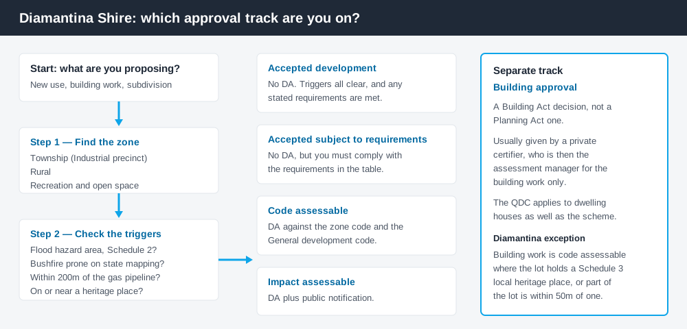
Figure 1: Two tracks run in parallel. Answering one does not answer the other.
The Diamantina Shire Council Planning Scheme 2021
The gazette notice was published in Government Gazette No. 56 on 2 July 2021, and the commencement date was 9 July 2021. It replaced the Diamantina Shire Planning Scheme 2006, still published in consolidated form.
It follows the standardised structure used across Queensland — strategic framework, tables of assessment, zones, codes — but Queensland schemes share that structure, not their content, and this one is small. There are only three zones: Township, which carries an Industrial precinct, Rural, and Recreation and open space. Three codes carry the benchmarks: General development, Reconfiguring a lot, and Operational work.
With no Rural residential zone, almost every property outside the two town footprints sits in the single Rural zone. What zone your property is in covers how to read that.
No overlays — the constraints sit in Schedule 2 and state mapping
Spend 5 minutes, not 3 weeks
instantDA generates a council-ready planning report for Queensland development applications. No town planner. No waiting.
Get your report →The scheme has no overlay codes. Where a city scheme would send you to a flood overlay, Diamantina's tables point straight at maps, and one phrase recurs down the columns: a use is accepted development only if it is not located in a flood hazard area on Schedule 2 – Flood mapping.
Schedule 2 carries four flood maps — the Queensland Flood Plain Assessment Overlay across the shire, then refined Birdsville, Bedourie and Betoota maps. Bushfire works differently: the tables send you to state mapping, not a council layer. Flood hazard overlays explains the behaviour.
Two approval tracks, not one
Development approval is a Planning Act 2016 decision. Council is the assessment manager for most applications, and it deals with land use, siting, scale and compliance with the codes.
Building approval is a Building Act decision about whether the structure complies with the building assessment provisions, usually given by a private certifier — who then becomes the assessment manager for building work only, as the Planning Regulation 2017 sets out.
One Diamantina twist sits in the building work table: building work is otherwise accepted, but becomes code assessable where the lot is or contains a local heritage place listed in Schedule 3, or shares a boundary with such a lot and any part of it falls within 50m of the place. Building approval versus development approval covers the distinction.
- ✓Which of the three zones?
- ✓Industrial precinct?
- ✓Flood hazard area on Schedule 2?
- ✓Bushfire prone on state mapping?
- ✓Within 50m of a Schedule 3 heritage place?
- ✓Building approval too?
Checking your own address
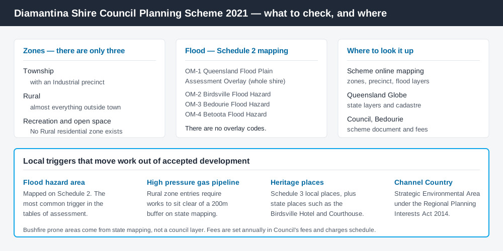
Figure 2: What Diamantina publishes, and what each source is for.
Diamantina does not run an ePlan platform. Schedule 2 names the Diamantina Shire Council Planning Scheme Online Interactive Mapping, a state-hosted ArcGIS application, and lists what it carries: the three zones, the Industrial precinct, the Queensland floodplain assessment overlay layer, and a refined Bedourie 1% annual exceedance probability flood layer.
For state layers — matters of state environmental significance, state-controlled roads, heritage places — cross-check the site on the Queensland Globe.
What catches Diamantina owners out
Flood. The strategic framework is blunt: Bedourie sits on Eyre Creek, Birdsville in the flow path and floodplain of the Diamantina River, Betoota near Browns Creek, all three prone to inundation. If your site is mapped, assume the category of assessment changes.
The high pressure gas pipeline. The most easily missed trigger in the scheme. Through the Rural zone table, accepted development is repeatedly conditioned on buildings and works not being located within 200m of the high pressure gas pipeline on state hazard mapping. Nothing on the ground tells you it is there.
Events and accommodation. The shire runs on event tourism — the Simpson Desert Racing Carnival taking in the Birdsville, Bedourie and Betoota races, the Big Red Bash, the Bedourie Camel Races. Short-term accommodation is accepted development in the Rural zone only where it is farm stay style, no more than five cabins, and clear of mapped flood and bushfire areas and the pipeline buffer. Anything larger is a material change of use. Short stay accommodation covers the category.
The Channel Country. The scheme records that the shire includes the Channel Country Strategic Environmental Area, its environmental attributes defined in the Regional Planning Interests Regulation 2014. It does not replace your DA; on resource and some other regulated activities it applies as well. Building on rural land covers the wider picture.
When you will probably need a DA
Work that starts a new use, intensifies an existing one, subdivides, alters the shape of the land through earthworks or clearing, or sits in a mapped flood hazard area is likely to be assessable. In the Township zone a dwelling house is accepted development where it is outside the Industrial precinct, clear of mapped flood and bushfire areas, and no more than 8.5m high. A home-based business is accepted up to 50m² of gross floor area, and only where it does not include bed and breakfast style accommodation.
What to do next
Get the zone from Council's online interactive mapping, check Schedule 2 flood mapping for the same address, then read the table of assessment for what you intend.
If you'd rather see the zone, the mapped constraints and the likely category of assessment for a Diamantina address in one place, an instantDA planning report does that for $169 — against the $800–$1,500 a town planner charges for a preliminary opinion. You can start a report in minutes.
Then call Council on the number on its Planning and Development page, which also holds the scheme and the fee schedule. In a shire this small, one call to the administration centre in Herbert Street, Bedourie beats hours of reading.
Frequently asked questions
What is Diamantina Shire's planning scheme?
Does Diamantina Shire have online planning maps?
How much does a development application cost in Diamantina?
Are there overlays in the Diamantina planning scheme?
Do I need approval for a house in Bedourie or Birdsville?
Ready to generate your report?
Skip the writing. Get a council-ready planning report in 5 minutes.
Get your report