Key takeaways
- ✓The scheme is the Goondiwindi Region Planning Scheme (Version 2), incorporating Amendment No. 1, effective 5 June 2020.
- ✓Six overlays apply: biodiversity areas, bushfire hazard, flood hazard, heritage, infrastructure and natural resources.
- ✓Flood mapping runs at three scales, including a dedicated Goondiwindi town map behind the 1958 levee.
- ✓The Rural zone is split into precincts with very large minimum lot sizes, protecting irrigated cropping country.
- ✓Council is reviewing the scheme through 2026, so check the current version before you rely on it.
Do You Need Council Approval in Goondiwindi Region?
You'll usually hear this called a development application, or DA — that's the formal name for council approval under the Planning Act 2016. In the Goondiwindi Region, Council is the assessment manager, and the rules it applies come from the Goondiwindi Region Planning Scheme (Version 2).
This is border country. The Macintyre River forms the state border along the region's southern edge, the town of Goondiwindi sits behind a levee bank built in 1958, and the Dumaresq, Macintyre and Weir rivers and the Macintyre Brook carry the irrigation water behind this cotton and grain country. Roughly 19,300 square kilometres and about 10,300 people, across Goondiwindi, Inglewood, Texas, Yelarbon, Toobeah, Bungunya and Talwood.
In this guide: how the scheme works, the two approval tracks, checking an address, and what catches owners out.
Get a council-ready planning report in 5 minutes — no planner, no waiting.
Get your report →The short answer
You need a development application when the Goondiwindi Region Planning Scheme makes your work assessable for its zone. Plenty of modest work in town is accepted development. Flood mapping and the Rural zone precincts are what most often push work into assessment, and building approval is a separate approval again.
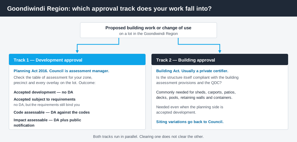
Figure 1: Two tracks run in parallel. Answering one does not answer the other.
The Goondiwindi Region Planning Scheme
Council adopted Amendment No. 1 to the scheme on 27 May 2020, and the amended scheme took effect on 5 June 2020. The documents you download are titled Goondiwindi Region Planning Scheme (Version 2), and that is the version used to assess development applications.
It follows the structure used across Queensland — strategic framework, zones, overlays, tables of assessment, codes — but the content is local. Queensland schemes share a structure, not a rulebook. There are eleven zones: Centre, Community facilities, General residential, Low impact industry, Medium impact industry, Mixed use, Recreation and open space, Rural residential, Rural, Special industry and Township. Several carry precincts that change the rules inside the zone — the Centre zone alone has central business district, highway commercial, Pratten Street and town commercial precincts. Working out what zone your property is in is always the first step.
One live caveat: Council started a review of the scheme in 2026, with workshops and a public survey that closed in May. That does not change your obligations today, but confirm you are reading the current version rather than a saved copy.
Six overlays, and the ones that bite
Spend 5 minutes, not 3 weeks
instantDA generates a council-ready planning report for Queensland development applications. No town planner. No waiting.
Get your report →The scheme carries six overlays: biodiversity areas, bushfire hazard, flood hazard, heritage, infrastructure and natural resources. Two of them do most of the work here.
Flood hazard is mapped at three scales — a regional map, a major towns map, and a dedicated Goondiwindi town map. That third map exists for a reason. Serious flooding in the 1950s prompted the levee bank around the town in 1958, and the strategic framework records that the levee protected Goondiwindi through the major events that followed. The scheme's stated approach is avoidance first: keep development off land subject to flooding in the defined flood event, and manage the risk where it cannot be avoided. Flood hazard overlays explains how that plays out.
Natural resources is where agricultural land protection sits. There is no separately named good quality agricultural land overlay here — the protection runs through the natural resources overlay and the strategic framework, which is blunt about preventing fragmentation of productive rural land and about buffering agriculture from encroaching residential use.
- ✓Zone and precinct?
- ✓Flood hazard, and which map?
- ✓Natural resources?
- ✓Bushfire, biodiversity, heritage?
- ✓Accepted, or assessable?
- ✓Building approval too?
Two approval tracks, not one
Development approval is a Planning Act 2016 decision about land use, siting, scale and compliance with the scheme's codes. Council is the assessment manager.
Building approval is a Building Act decision about whether the structure complies with the building assessment provisions, usually given by a private certifier rather than Council. Sheds, carports, patios, pools, retaining walls and shipping containers routinely need one even when the planning side is accepted development. Building approval versus development approval covers where the line falls.
Goondiwindi does not run a public e-lodgement portal of its own. Applications use the standard state DA forms — DA Form 1 and its supporting parts — lodged with Council with plans, reports and fees. Planning Services is the practical first contact.
Checking your own address
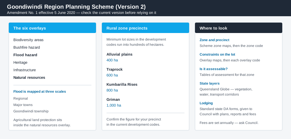
Figure 2: What the scheme maps, and where each answer actually lives.
Council publishes the scheme as documents, with zone maps and overlay maps as separate downloads — the flood maps indexed as regional, major towns and Goondiwindi. Work through them in order: zone and precinct, then each overlay map for the same lot, then the table of assessment.
For state layers outside the scheme entirely — vegetation, regulated water, transport corridors — cross-check the site on the Queensland Globe.
What catches Goondiwindi owners out
Assuming the levee means no flood constraint. It does not. The town is mapped in its own right, and being behind a levee is not the same as being outside the flood hazard overlay. That distinction changes the category of assessment.
Rural zone lot sizes. Minimum lot sizes in the Rural zone run into the hundreds of hectares, and they vary with the land system across the region rather than being a single number. Check the figure that applies to your own land in the scheme's development codes before assuming anything — anyone imagining a small rural cut-out should read reconfiguring a lot first.
Treating rural as unregulated. Earthworks, clearing, new dwellings, worker accommodation and intensive agriculture all engage the scheme. Building on rural land sets out what is assessable there.
When you will probably need a DA
Work that starts a new use or materially intensifies an existing one, subdivides or realigns boundaries, involves operational works such as earthworks or access, sits within the flood hazard overlay, or affects mapped natural resource values is likely to be assessable. Modest domestic work in town on an unconstrained lot far more often falls to accepted development, sometimes subject to requirements.
What to do next
Get the zone and precinct, check every overlay map for the same lot, then read the table of assessment for the specific use or work.
If you would rather see the zone, the mapped constraints and the likely category of assessment in one place, an instantDA planning report does that for $169 — against the $800–$1,500 a town planner typically charges for a preliminary opinion. You can start a report in a few minutes.
Then call Council. Fees change each financial year, so you need a current quote anyway. Council's Planning and Development pages hold the scheme, the maps and the contacts.
Frequently asked questions
What planning scheme applies in the Goondiwindi Region?
Does the Goondiwindi levee mean my property is not flood affected?
Does Goondiwindi Regional Council have an online DA lodgement portal?
How is agricultural land protected in the scheme?
How much does a development application cost here?
Ready to generate your report?
Skip the writing. Get a council-ready planning report in 5 minutes.
Get your report