Key takeaways
- ✓The current Lockyer Valley Planning Scheme commenced on 22 July 2024 and replaced the old Gatton, Laidley and Grantham schemes.
- ✓Flood is regulated by a Temporary Local Planning Instrument, TLPI 2026, which took effect on 20 July 2026 while updated flood modelling is finished.
- ✓The Agricultural land overlay protects Important agricultural areas and ALC Class A and B soils across the valley floor.
- ✓Development applications are lodged by email or in person — this council does not use an online lodgement portal.
- ✓Development approval and building approval are separate. One does not substitute for the other.
Do You Need Council Approval in Lockyer Valley?
You'll usually hear this called a development application, or DA — that's the formal name for council approval under the Planning Act 2016. In the Lockyer Valley, Council is the assessment manager, and the rules it applies come from the Lockyer Valley Planning Scheme, which commenced on 22 July 2024.
Two things make this council different. It sits on some of the most productive irrigated cropping soil in Queensland, and the scheme protects that soil hard. And flood regulation here currently runs through a temporary instrument rather than the scheme's own overlay.
Get a council-ready planning report in 5 minutes — no planner, no waiting.
Get your report →The short answer
You need a development application when the Lockyer Valley Planning Scheme makes your work assessable for the zone, precinct and overlays on your land. A lot of minor domestic work is accepted development. Building approval is separate, and is usually decided by a private certifier rather than Council.
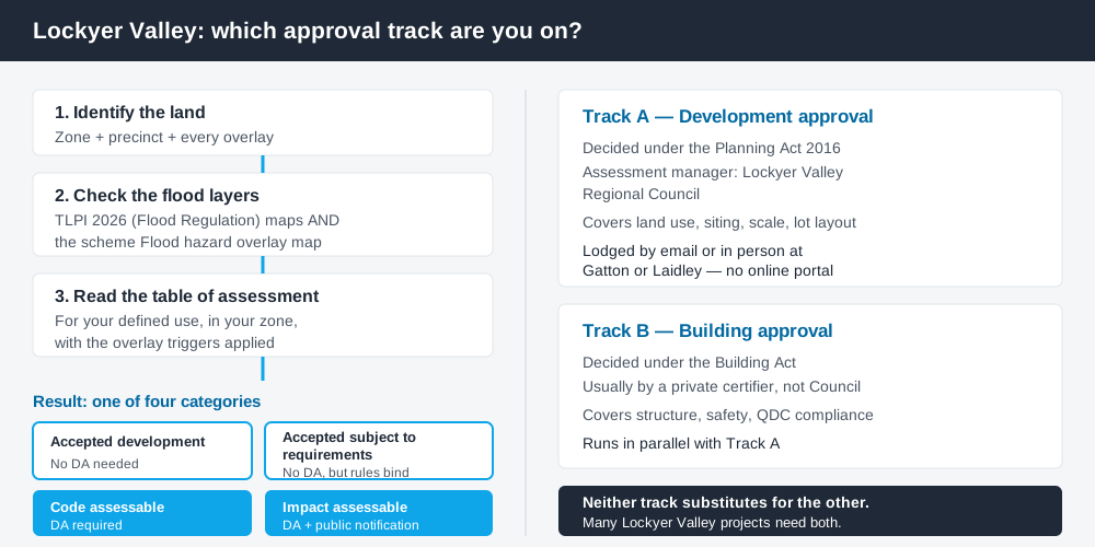
Figure 1: Two tracks run in parallel. Answering one does not answer the other.
The Lockyer Valley Planning Scheme
The scheme commenced on 22 July 2024 and superseded the separate Gatton, Laidley and Grantham schemes. If you are working from advice given before that date, it is out of date. Council has since applied an administrative amendment effective 24 November 2025, with further amendments in preparation.
Like every Queensland scheme it follows the standardised Queensland Planning Provisions structure — strategic framework, zone codes, overlay codes and tables of assessment — but the codes layered over it are local. Zones you will actually meet here include the Rural zone, Rural residential zone, Township zone, Low density residential zone, Emerging community zone and Limited development zone.
Precincts sit under several of those zones and change the numbers — the Low density residential zone, for instance, distinguishes suburban from acreage. Reading the zone without the precinct gives you the wrong answer. How to find out what zone your property is in covers that structure generally.
Two approval tracks, not one
Spend 5 minutes, not 3 weeks
instantDA generates a council-ready planning report for Queensland development applications. No town planner. No waiting.
Get your report →Development approval is a Planning Act 2016 decision, with Council as assessment manager. It deals with land use, siting, scale, lot layout and compliance with the codes in the scheme.
Building approval is a Building Act decision about whether the structure complies with the building assessment provisions, usually given by a private certifier. A farm shed can be accepted development under the scheme and still need building approval, and holding a building approval does not cure the absence of a development approval. Building approval versus development approval covers the distinction in full.
Plumbing and on-site sewerage add a third track, which matters more here than in a serviced city because much of the region is unsewered.
- ✓What zone and precinct applies?
- ✓Which overlays touch the land?
- ✓Is the site inside the TLPI flood mapping?
- ✓Is the work assessable or accepted development?
- ✓Do you also need building approval?
- ✓Is on-site sewerage involved?
Checking your own address
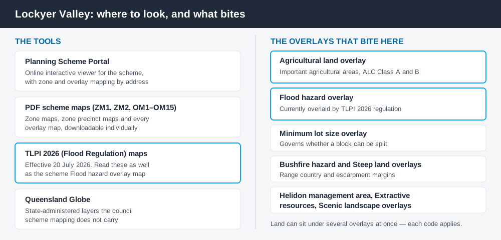
Figure 2: What each Lockyer Valley tool is actually for.
Council publishes the scheme through its Planning Scheme Portal, an online interactive viewer with zone and overlay mapping, reached from the Lockyer Valley Planning Scheme page. That page also hosts the full PDF map set, so you can open a single overlay map directly if the portal is not cooperating. The TLPI flood maps sit on the same page, and you need to read them as well as the scheme's Flood hazard overlay map. For state layers such as vegetation, cross-check the site on the Queensland Globe.
Lodgement is deliberately low-tech. Council takes development applications by email or in person at Gatton or Laidley. There is no online lodgement portal, so your application is only properly made if the forms, fee, owner's consent and supporting information are all there. Pre-lodgement meetings are held at no charge. How to lodge a DA in Queensland sets out what a properly made application contains.
What catches Lockyer Valley owners out
Agricultural land. The Agricultural land overlay protects Important agricultural areas and ALC Class A and B soils, and the strategic framework is explicit that these are protected from fragmentation and from encroachment by sensitive uses. A house or rural industry proposed on Class A cropping soil faces a real policy hurdle, not a formality. Building on rural land in Queensland covers the pattern.
Flood. Twelve people died at Grantham in the January 2011 flash flood, and the Strengthening Grantham Project that followed relocated part of the town onto higher ground through a voluntary land swap — an Australian first. That history is why flood regulation here is unusually live. Council adopted the Temporary Local Planning Instrument 2026 (Flood Regulation) on 15 July 2026, effective 20 July 2026, to keep floodplain development regulated while updated modelling is completed. The flood hazard overlay explained covers how these provisions work.
Rural residential pressure. The valley sits between Brisbane and Toowoomba, and demand for acreage lots is constant. Subdivision is governed by the Rural residential zone precincts and the minimum lot size mapping, and assuming a big block can be halved is the most common expensive mistake here. The rural residential zone explains the reasoning. The Helidon management area, Extractive resources and Steep land overlays also bite in specific parts of the region.
When you will probably need a DA
Work that changes the use of land, adds a dwelling, subdivides, sits on mapped agricultural land, or falls inside the flood mapping is likely to be assessable. Modest domestic work on an unconstrained township lot is much more often accepted development.
What to do next
Open the Planning Scheme Portal, record the zone, precinct and every overlay, check the TLPI flood maps, then read the table of assessment for what you intend to build.
Fees are set annually in Council's register of fees and charges. In the 2025/26 register, a material change of use application for a Dwelling house — code or impact assessment — is listed at $2,105.00. Check the current register before budgeting, because these figures move each July.
If you'd rather see the zone, the overlays and the likely category of assessment for a Lockyer Valley address in one place, an instantDA planning report does that for $169 — against the $800–$1,500 a town planner typically charges for a preliminary opinion. You can start a report in a few minutes, then book a free pre-lodgement meeting to confirm your reading with Council.
Frequently asked questions
What is the Lockyer Valley's planning scheme?
How do I check zoning and overlays for a Lockyer Valley property?
How do I lodge a development application with Lockyer Valley Regional Council?
Why is flood handled by a temporary instrument here?
Is building approval the same as council approval?
Ready to generate your report?
Skip the writing. Get a council-ready planning report in 5 minutes.
Get your report