Key takeaways
- ✓Logan's scheme is the Logan Planning Scheme 2015. Council lists the current version as V9.2, commenced 1 July 2025.
- ✓Flood mapping in Logan is currently driven by a temporary local planning instrument, not the original scheme maps.
- ✓The Biodiversity areas overlay maps koala corridors and vegetation management areas across a lot of Logan's south and east.
- ✓Yarrabilba and Greater Flagstone are Priority Development Areas — the State decides applications there, not Council.
- ✓Development approval and building approval are separate. Most homes need both.
Do You Need Council Approval in Logan?
You'll usually hear this called a development application, or DA — that's the formal name for council approval under the Planning Act 2016. In Logan, the rules Council applies come from the Logan Planning Scheme 2015, and Council is the assessment manager for most applications.
Logan is unusual in three ways that matter before you design anything. Its flood mapping is currently carried by a temporary instrument sitting over the scheme. Much of its land carries koala and vegetation mapping. And two large parts of the city are not assessed by Council at all.
Get a council-ready planning report in 5 minutes — no planner, no waiting.
Get your report →The short answer
In Logan you need a development application when the Logan Planning Scheme 2015 makes your work assessable for your zone and overlays. Much minor domestic work is accepted development. Building approval is separate and usually sits with a private certifier. Inside the Yarrabilba and Greater Flagstone Priority Development Areas, the State decides instead.
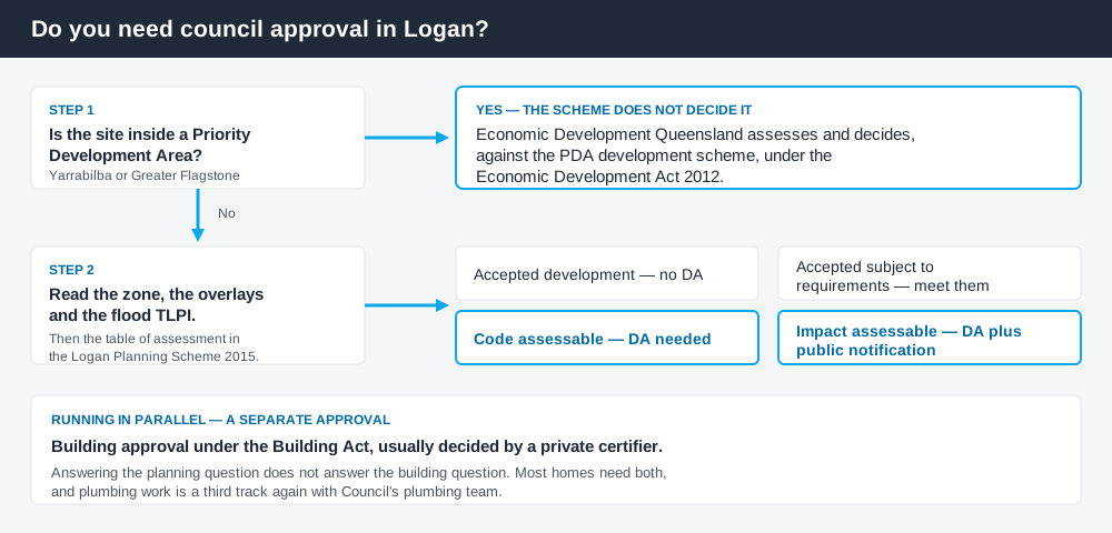
Figure 1: Two tracks run in parallel — and a third path applies inside the PDAs.
The Logan Planning Scheme 2015
Logan's local planning scheme is the Logan Planning Scheme 2015. Council's planning scheme page lists the current version as V9.2, commenced on 1 July 2025. It has been amended repeatedly rather than replaced, and a replacement scheme, Logan Plan, is in preparation — so a position you checked two years ago may have moved.
The scheme follows the Queensland Planning Provisions structure with Logan's own codes layered on top: tables of assessment in Part 5, zone codes in Part 6, local plans in Part 7 and overlay codes in Part 8. Zones include Low density residential, Low-medium density residential, Emerging community, Rural residential and — distinctively — a Priority development area zone. How to find out what zone your property is in covers reading that structure.
Two approval tracks, not one
Spend 5 minutes, not 3 weeks
instantDA generates a council-ready planning report for Queensland development applications. No town planner. No waiting.
Get your report →Development approval is a Planning Act 2016 decision. Council is the assessment manager, dealing with land use, siting, scale and compliance with the codes in the scheme.
Building approval is a Building Act decision about whether the structure meets the building assessment provisions, and is usually given by a private certifier rather than Council.
They are separate approvals under separate legislation with separate decision-makers. A patio can be accepted development under the scheme and still need building approval, and holding a building approval does not cure a missing development approval. Building approval versus development approval sets out the distinction properly.
- ✓Is the site inside a Priority Development Area?
- ✓What is the zone?
- ✓Which overlays apply?
- ✓Is the site flood affected under the current TLPI?
- ✓Is the work accepted, accepted subject to requirements, code assessable or impact assessable?
- ✓Do you also need building approval?
Checking your own address
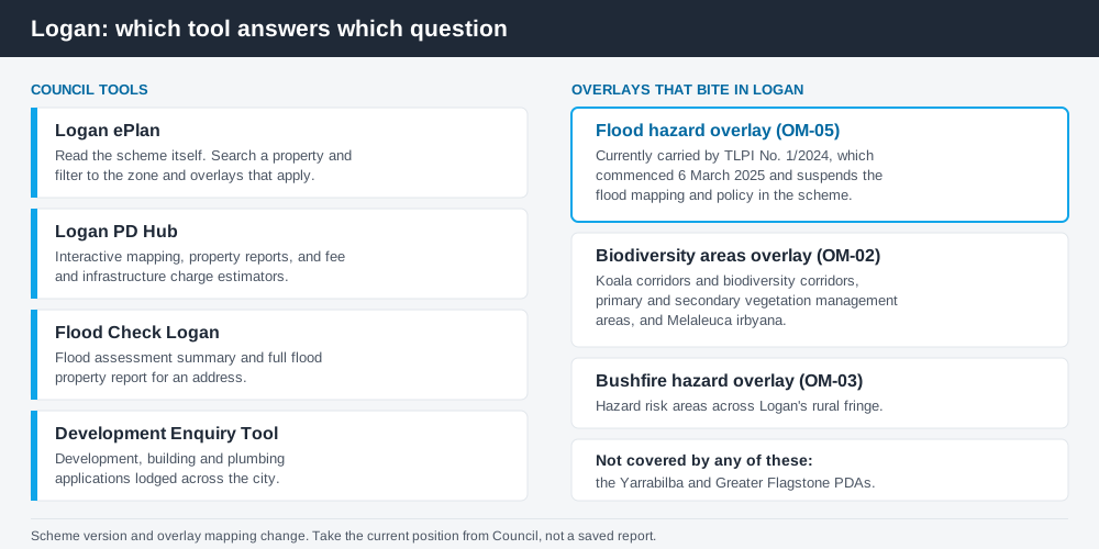
Figure 2: Four Council tools, doing four different jobs.
Council runs the Logan ePlan, an online viewer for the scheme itself. You can search for a property, filter the parts of the scheme relevant to it based on zoning and applicable overlays, and print a PDF of part or all of the scheme.
Alongside it sits the Logan PD Hub, Council's central set of planning and development tools: interactive mapping of zones and overlays, property and flooding reports, and fee and infrastructure charge estimators. Flood Check Logan, within the Hub, gives you a flood assessment summary and full property report for an address.
The Development Enquiry Tool shows development, building and plumbing applications lodged across the city. What has been approved on comparable sites near you tells you more about what Council accepts than the code text does.
What catches Logan owners out
Flood, and the instrument carrying it. Temporary local planning instrument No. 1/2024 gives legal effect to updated flood mapping and policy in Logan. It commenced on 6 March 2025, replacing TLPI No. 1/2023, and it suspends the existing flood mapping and policy in the scheme. The flood position for your lot is therefore not necessarily what the original scheme maps show — some properties gained a risk rating under it, some lost one. The flood hazard overlay explained covers how these overlays drive floor levels and categories of assessment.
Koala and vegetation mapping. The Biodiversity areas overlay code maps koala corridors and biodiversity corridors, primary and secondary vegetation management areas, and locally significant vegetation including Melaleuca irbyana. Clearing native vegetation in these areas typically triggers ecological assessment or an offset, and State koala protections sit over the top of that separately. Koala habitat and development in Queensland covers the state layer.
Assuming the scheme applies everywhere. It does not. Yarrabilba and Greater Flagstone are Priority Development Areas under the Economic Development Act 2012. Economic Development Queensland assesses and decides applications there against the relevant PDA development scheme, and Council's flood TLPI expressly does not apply inside them.
Dual living. Logan has a large secondary dwelling and dual occupancy market, and the two are different things with different consequences for use and letting. Secondary dwelling versus dual occupancy is worth reading before you commit to a design.
When you will probably need a DA
The pattern is fairly consistent. Work that changes the use of a property, adds a dwelling, subdivides, clears native vegetation in a mapped corridor, or sits in flood affected land is likely to be assessable. Modest domestic work on an unconstrained lot is much more often accepted development, subject to any requirements attached to it. Council's cost-recovery fee register is the anchor for cost, and it is reset each financial year.
What to do next
Check the zone and overlays in the Logan ePlan, run a flood report through the Logan PD Hub, then read the table of assessment for what you intend to do.
If you'd rather see the zone, the overlays and the likely category of assessment for a Logan address pulled together in one place, an instantDA planning report does that for $169 — against the $800–$1,500 a town planner typically charges for a preliminary opinion. You can start a report in a few minutes.
Then confirm with Council before you engage a designer, particularly if flood, a koala corridor or a PDA boundary is near your lot.
Frequently asked questions
What is Logan's planning scheme?
Why doesn't the flood map in the scheme match what Council tells me?
Who approves development in Yarrabilba and Greater Flagstone?
How much is a development application in Logan?
Is building approval the same as council approval in Logan?
Ready to generate your report?
Skip the writing. Get a council-ready planning report in 5 minutes.
Get your report