Key takeaways
- ✓The scheme is the Mareeba Shire Council Planning Scheme 2016, currently the Major Amendment No. 1 of 2023 version, in effect from 8 December 2023.
- ✓That amendment protects the Rural zone from subdivision of lots under 60 hectares — the single most consequential local rule in the shire.
- ✓Council's public IntraMaps viewer is the mapping tool for checking zone, local plan and overlays for an address.
- ✓Mareeba's overlay set is rural in character: agricultural land, bushfire hazard, hill and slope, scenic amenity and airport environs.
- ✓Development approval and building approval are separate. A private certifier usually handles the building side.
Do You Need Council Approval in Mareeba Shire?
You'll usually hear this called a development application, or DA — that's the formal name for council approval under the Planning Act 2016. In Mareeba Shire, Council is the assessment manager for most of them, and the rules it applies come from the Mareeba Shire Council Planning Scheme 2016.
What makes this shire unusual is its extent. Mareeba Shire covers roughly 53,500 square kilometres, from Kuranda on the rainforest edge above Cairns, west across the irrigated farming country around Mareeba and Dimbulah, out to Chillagoe and beyond. One scheme has to work for a village in World Heritage rainforest and for a cattle property four hours west of it.
Get a council-ready planning report in 5 minutes — no planner, no waiting.
Get your report →The short answer
In Mareeba Shire you need a development application when the Mareeba Shire Council Planning Scheme 2016 makes the work assessable for your zone, local plan and overlays. Plenty of minor domestic work is accepted development. Building approval is a separate decision, usually made by a private certifier rather than Council.
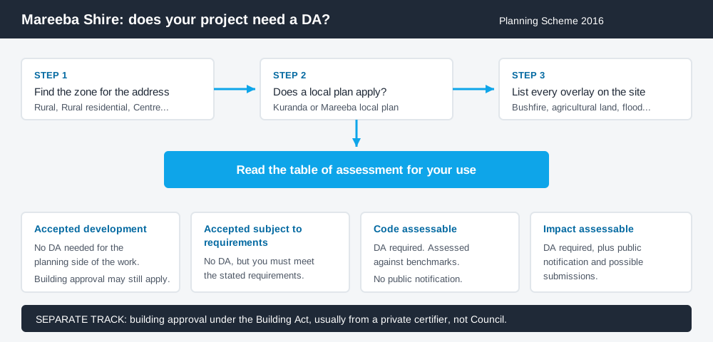
Figure 1: Two tracks run in parallel. Answering one does not answer the other.
The Mareeba Shire Council Planning Scheme 2016
Mareeba Shire Council was re-established as a separate council on 1 January 2014, after de-amalgamating from Tablelands Regional Council. The scheme it runs on commenced on 1 July 2016. The current version published by Council is the Major Amendment No. 1 of 2023 version, adopted on 28 November 2023 and having effect from 8 December 2023.
Like every Queensland scheme it follows the QPP structure — strategic framework, zone codes, overlay codes and tables of assessment — but the content inside is Mareeba's own. Queensland schemes are far less standardised than people assume, so a rule you read for a neighbouring council does not carry across.
The scheme uses ten zones, including the Rural zone, Rural residential zone, Low density residential zone, Centre zone, Industry zone, Emerging community zone and Conservation zone. Above the zone sit two local plans — the Kuranda local plan and the Mareeba local plan. If your property sits in either, the local plan code is part of your answer.
Two approval tracks, not one
Spend 5 minutes, not 3 weeks
instantDA generates a council-ready planning report for Queensland development applications. No town planner. No waiting.
Get your report →Development approval is a Planning Act 2016 decision. Council is the assessment manager, dealing with land use, siting, scale and compliance with the codes in the scheme.
Building approval is a Building Act decision about whether the structure meets the building assessment provisions, including the QDC. It is usually given by a private certifier, not Council.
Separate legislation, separate decision-makers. A farm shed can be accepted development under the scheme and still require building approval, and a building approval does not cure a missing development approval. Building approval versus development approval sets out the distinction.
- ✓What zone is the land in?
- ✓Does a Kuranda or Mareeba local plan apply?
- ✓Which overlays touch the site?
- ✓Is the work accepted, code assessable or impact assessable?
- ✓Do you also need building approval?
- ✓Is there plumbing work?
Checking your own address
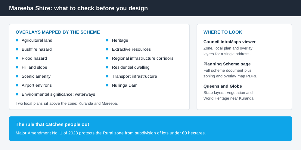
Figure 2: The overlay set that actually bites in Mareeba Shire.
Council links a public IntraMaps mapping viewer directly from its website header, and that is the tool for checking a Mareeba Shire address. Search the property, then turn on the planning layers to see the zone, any local plan, and the overlays. Council also publishes the scheme's zoning, local plan and overlay maps as PDFs on its Planning Scheme page.
Cross-check the site on the Queensland Globe as well. State-administered layers — vegetation, protected areas and World Heritage boundaries near Kuranda — are not all in the council scheme, and here they matter. How to check overlays covers the method.
What catches Mareeba Shire owners out
Rural subdivision. This is the big one. Major Amendment No. 1 of 2023 was titled Subdivision in the Rural zone, and Council states its purpose is to protect the Rural zone from the subdivision of lots less than 60 hectares in area, maintaining the intended character of the zone and addressing the intent of the Far North Queensland Regional Plan. Owners who bought rural land expecting to split it are often surprised. Reconfiguring a lot explains an ROL.
Agricultural land. The scheme carries an agricultural land overlay. The irrigated country around Mareeba and Dimbulah is supplied by the Mareeba–Dimbulah Water Supply Scheme from Tinaroo Falls Dam, and protecting that productive land from fragmentation and incompatible neighbours is a live consideration. Building on rural land is worth reading first.
Bushfire. A bushfire hazard overlay applies across dry tropical savanna land through much of the shire, driving siting, access and water supply requirements. The bushfire hazard overlay covers what assessment against it involves.
The other overlays. Mareeba's set also includes airport environs, flood hazard, hill and slope, scenic amenity, waterways, extractive resources, heritage and Nullinga Dam. Remote western properties are not overlay-free by default.
When you will probably need a DA
Work that changes the use of a property, adds a dwelling, subdivides land, sits in a bushfire, flood, hill and slope or agricultural land overlay, or exceeds a threshold in the applicable code, is likely to be assessable. Anything in the Rural zone involving new lots needs checking against the 2023 amendment first.
Modest domestic work on an unconstrained township lot is much more often accepted development, sometimes accepted subject to requirements — a different category, meaning conditions attach automatically. The only reliable route is the table of assessment for your defined use.
Council's fees are reset annually in its Schedule of Fees and Charges, published via Council's Fees and Charges page. For scale, an applicant's covering letter for a 2025 one-into-two reconfiguring a lot application in Mareeba calculated the fee at $1,241.00 under Council's 2025/2026 schedule — an order of magnitude only.
What to do next
Find the address in Council's IntraMaps viewer and write down the zone, any local plan, and every overlay. Then read the table of assessment for what you intend to do.
If you would rather see the zone, overlays and likely category of assessment for a Mareeba Shire address in one place, an instantDA planning report does that for $169 — against the $800–$1,500 a town planner typically charges for a preliminary opinion. You can start a report in a few minutes.
Then confirm with Council before commissioning drawings, especially for rural land.
Frequently asked questions
What is Mareeba Shire's planning scheme?
Can I subdivide rural land in Mareeba Shire?
How do I check the zoning of a Mareeba Shire property?
Is building approval the same as council approval in Mareeba Shire?
Does the Wet Tropics World Heritage Area affect development near Kuranda?
Ready to generate your report?
Skip the writing. Get a council-ready planning report in 5 minutes.
Get your report