Key takeaways
- ✓The scheme is the McKinlay Shire Planning Scheme, gazetted 18 April 2019 and commenced 26 April 2019.
- ✓There are only four zones — Township, Recreation and open space, Rural residential, and Rural.
- ✓There are no overlay codes. Flood comes from the scheme's own Schedule 2 maps FH1 to FH5; bushfire comes from state mapping.
- ✓The Walkabout Creek Hotel at McKinlay is on the scheme's local heritage register, along with Combo Waterhole near Kynuna.
- ✓There is no online lodgement portal — applications go to Council by email, and assessment starts once the fee is paid.
Do You Need Council Approval in McKinlay Shire?
You'll usually hear this called a development application, or DA — that's the formal name for council approval under the Planning Act 2016. In McKinlay Shire, Council is the assessment manager, and the rules it applies come from the McKinlay Shire Planning Scheme.
One thing trips people up first. The shire is McKinlay, but the main town is Julia Creek — the administration centre, 650 kilometres west of Townsville and home to roughly 55 per cent of residents. McKinlay is a separate, smaller township on the Landsborough Highway, known for the Walkabout Creek Hotel from the 1986 film Crocodile Dundee. Council's Corporate Plan records 40,818 square kilometres and a population of 849.
In this guide: how the scheme works, the two approval tracks, how to check an address, and what catches owners out.
Get a council-ready planning report in 5 minutes — no planner, no waiting.
Get your report →The short answer
In McKinlay Shire you need a development application when the McKinlay Shire Planning Scheme makes the work assessable for your zone. Plenty of modest work in the townships is accepted development. Building approval is separate, usually given by a private certifier, and lodged with Council afterwards.
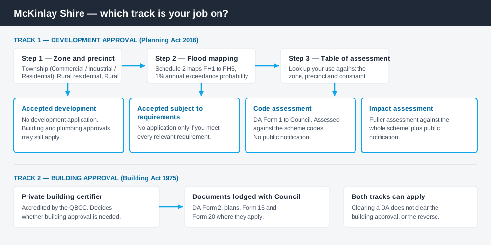
Figure 1: Two tracks run in parallel. Answering one does not answer the other.
The McKinlay Shire Planning Scheme
Council resolved to adopt the scheme at its April 2019 meeting. A notice appeared in Government Gazette No. 86 on 18 April 2019, and the commencement date was 26 April 2019.
It follows the standardised Queensland structure — strategic framework, tables of assessment, zones, codes, schedules — but schemes share that structure, not their content. There are four zones: Township, Recreation and open space, Rural residential, and Rural. Almost the entire shire is Rural.
The detail sits in the precincts. The Township zone splits into Commercial, Industrial and Residential precincts, and the tables of assessment turn on which one you are in — a shop in the Commercial precinct is treated very differently to the same shop in the Residential precinct. The Rural residential zone carries a No further subdivision precinct, which does what its name says. What zone your property is in is the first step every time.
Four codes do the assessment work: General development, Non-resident workforce accommodation, Operational work, Reconfiguring a lot. A four-zone scheme is not a lax scheme — it just has fewer places to hide the answer.
No overlays — the constraints sit in Schedule 2
Spend 5 minutes, not 3 weeks
instantDA generates a council-ready planning report for Queensland development applications. No town planner. No waiting.
Get your report →The scheme has no overlay codes at all. Where a city scheme would send you to an overlay, McKinlay's tables of assessment point straight at Schedule 2.
Schedule 2 holds ten maps: zone maps ZM01 to ZM05 — shire-wide, then Julia Creek, McKinlay, Kynuna and Nelia — and flood hazard maps FH1 to FH5 on the same footprint, showing the 1 per cent annual exceedance probability flood event. Read the tables and one condition recurs: work is accepted development only if it is not located in a flood hazard area on that mapping. Being inside the line often moves a job from needing no approval to needing one. Flood hazard mapping explains how these layers behave.
Bushfire works differently — the scheme sends you to state mapping of bushfire prone areas under the State Planning Policy, not a council layer.
- ✓Which of the four zones?
- ✓Which Township precinct?
- ✓Inside the FH flood hazard area?
- ✓Bushfire prone on state mapping?
- ✓On the local heritage register?
- ✓Building approval as well?
Two approval tracks, not one
Development approval is a Planning Act 2016 decision. Council is the assessment manager, dealing with land use, siting, scale and the scheme's codes. Council sets out four levels: accepted development, accepted development subject to requirements, code assessment, impact assessment. The first two differ — accepted subject to requirements means no application provided you meet every requirement, and you lose that the moment you don't.
Building approval is a Building Act 1975 decision about the structure itself. Council's Building Services page is blunt: building work is generally approved by an accredited private certifier rather than by Council, and the certifier lodges the documentation with Council afterwards. Building approval versus development approval explains the split.
Checking your own address
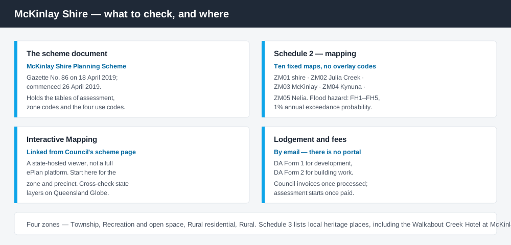
Figure 2: What McKinlay publishes, and what each source is actually for.
McKinlay runs no ePlan platform and no online lodgement portal. From its Planning Scheme page Council links the scheme document and an Interactive Mapping viewer on the state's ArcGIS platform — the practical starting point for zoning.
Lodgement is by email. Council's Lodgement of Application and Enquiries page states that an invoice issues once the application has been processed and that assessment commences upon receipt of payment. Applications use DA Form 1 for development, DA Form 2 for building work.
For state layers, cross-check the site on the Queensland Globe. Mining tenements sit on Mines Online Maps.
What catches McKinlay owners out
Flood. Julia Creek, McKinlay, Kynuna and Nelia each have their own flood hazard map for a reason. Inside the mapped area, assume the category of assessment changes.
Heritage. Schedule 3's local heritage register is real and it is local — the Walkabout Creek Hotel on Kirby Street at McKinlay is on it, as are Combo Waterhole near Kynuna, the Blue Heeler Hotel and the Julia Creek water tower. Check it before changing an older main-street building. Heritage listings covers what that means.
Workforce accommodation. With the St Elmo vanadium project and mines at Cannington and Eloise, the scheme carries a Non-resident workforce accommodation code — Council prefers camps within 50 kilometres of a town to sit in or beside it, with screening and a 25 per cent site cover limit.
Rural scale. Grazing dominates, and "rural means unregulated" is a costly assumption. Reconfiguring a lot, operational work such as earthworks or clearing, and extractive industry all engage the scheme, and the shire carries habitat for listed species including the Julia Creek dunnart. Building on rural land covers this.
When you will probably need a DA
Work that starts a new use, increases the intensity of an existing one, subdivides or realigns boundaries, reshapes the land through earthworks or clearing, or sits inside a mapped flood hazard area is likely to be assessable. Tourism is live here — the Dirt n Dust Festival and highway drive traffic make short-term accommodation a recurring material change of use. Modest work in town on an unconstrained lot is more often accepted.
What to do next
Get the zone and precinct from Council's interactive mapping, check the matching FH flood map, then read the table of assessment for what you intend to build.
If you'd rather see the zone, the mapped constraints and the likely category of assessment for a McKinlay address in one place, an instantDA planning report does that for $169 — against the $800–$1,500 a town planner typically charges for a preliminary opinion. You can start a report in minutes.
Then call Council. In a shire this size a conversation with the office at 29 Burke Street, Julia Creek beats an afternoon of reading. Council's Planning Scheme page has the document and the mapping link.
Frequently asked questions
What is McKinlay Shire's planning scheme?
Does McKinlay Shire have online planning maps?
How much does a development application cost in McKinlay Shire?
Are there overlays in the McKinlay planning scheme?
How do I lodge a development application in McKinlay Shire?
Ready to generate your report?
Skip the writing. Get a council-ready planning report in 5 minutes.
Get your report