Key takeaways
- ✓Paroo runs on the Paroo Shire Planning Scheme 2019, adopted 19 March 2019 and commenced 12 April 2019.
- ✓The scheme has seven zones and no overlay codes at all — flood is handled through the scheme's own flood mapping schedule.
- ✓An unlisted material change of use defaults to impact assessment, which brings public notification with it.
- ✓Yowah sits on the Yowah Opal Mining Fields, and the scheme treats mining leases, claims and disused shafts as real siting constraints.
- ✓Council's own fee register sets a code assessable application at $556.00 and an impact assessable one at $701.00 for FY2026-27.
Do You Need Council Approval in Paroo Shire?
You'll usually hear this called a development application, or DA — that's the formal name for council approval under the Planning Act 2016. In Paroo, Council is the assessment manager, and the rules it applies come from the Paroo Shire Planning Scheme 2019.
Paroo covers roughly 47,600 square kilometres of south-west Queensland, with a population under two thousand. The scheme describes four towns: Cunnamulla on the Warrego River, Eulo on the Paroo, Wyandra on the Mitchell Highway, and Yowah, which it says is "built on the Yowah Opal Mining Fields". Mulga grazing, wool, opal and tourism are the economy.
Get a council-ready planning report in 5 minutes — no planner, no waiting.
Get your report →The short answer
In Paroo Shire you need a development application when the Paroo Shire Planning Scheme 2019 makes your work assessable for its zone. Much minor work in the towns is accepted development. Building approval is a separate approval under different legislation, and it is usually a private certifier who gives it.
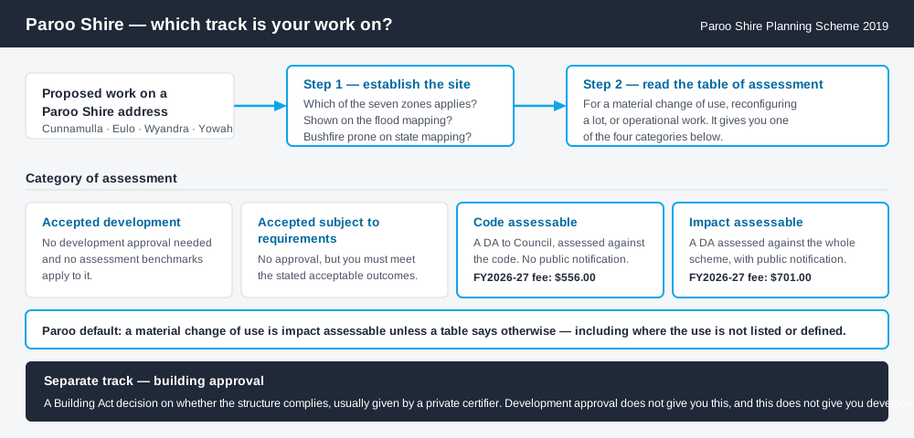
Figure 1: Two tracks run in parallel. Answering one does not answer the other.
The Paroo Shire Planning Scheme 2019
The scheme may be cited simply as the Paroo Shire planning scheme. Council decided to adopt it on 19 March 2019 and it commenced on 12 April 2019, replacing the 2006 scheme.
It follows the standardised Queensland structure — strategic framework, zones, tables of assessment, codes — but Queensland schemes share that structure, not their content, and Paroo's is lean. There are seven zones: Recreation and open space, Rural, General residential, Rural residential, Centre, Industry, and Township. Almost the entire shire is Rural. Cunnamulla carries most of the residential, centre and industry land; Eulo, Wyandra and Yowah are largely Township.
Behind the zones sit only a handful of codes — community residence, forestry for wood production, reconfiguring a lot, general development and operational works. What zone your property is in is the first move.
No overlay codes — the constraints sit elsewhere
Spend 5 minutes, not 3 weeks
instantDA generates a council-ready planning report for Queensland development applications. No town planner. No waiting.
Get your report →The most distinctive thing about planning in Paroo is that the scheme has no overlay codes. Where a city scheme would send you to a flood or bushfire overlay, Paroo's tables of assessment point straight at maps.
Flood is handled through the scheme's own flood mapping schedule. The strategic framework puts it plainly: flood assessment applies only to development on sites affected by flooding and shown on that mapping. Council publishes flood hazard maps for Cunnamulla, Eulo and Wyandra, plus a shire-wide Queensland floodplain map. Bushfire works differently — the scheme sends you to state mapping, not a council layer. Flood hazard overlays explains how these layers behave.
Two approval tracks, not one
Development approval is a Planning Act 2016 decision about land use, siting and scale. Council is the assessment manager.
Building approval is a Building Act decision about whether the structure complies with the building assessment provisions, usually given by a private certifier rather than Council. One does not give you the other. Building approval versus development approval covers the split.
Paroo publishes its fees in a Register of Recovery Fees. For FY2026-27 it sets a code assessable application at $556.00 and an impact assessable one at $701.00, reconfiguring a lot also at $701.00, and code assessable operational or building work at $452.00. Building fees are largely price on application, and figures change annually.
- ✓Which of the seven zones?
- ✓Shown on the flood mapping?
- ✓Bushfire prone on state mapping?
- ✓Mining lease, claim or old shaft?
- ✓Accepted, code or impact assessable?
- ✓Building approval too?
Checking your own address
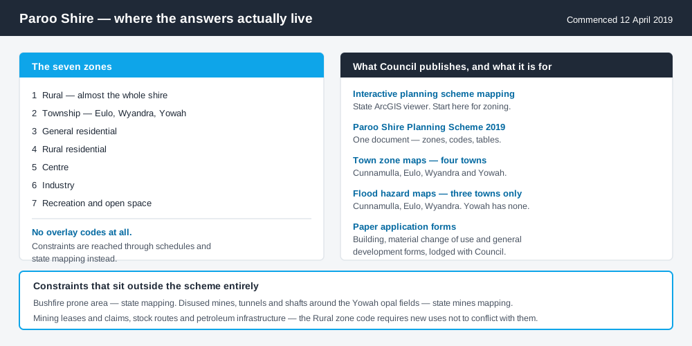
Figure 2: What Paroo publishes, and what each source is actually for.
Paroo does not run its own ePlan platform. From its Planning Scheme page Council links interactive planning scheme mapping on a state ArcGIS viewer, and that is the practical starting point for zoning. Council also publishes the scheme as a single document, with zone maps for Cunnamulla, Eulo, Wyandra and Yowah, a shire-wide zone map, a context map and the strategic framework.
Note the asymmetry: zone maps for all four towns, flood hazard maps for only three. Yowah has none. Cross-check the site on the Queensland Globe for state layers.
What catches Paroo owners out
Impact assessment is the default. This is the big one. Under the scheme, a material change of use is assessable development requiring impact assessment unless the table of assessment says otherwise, and specifically where a use is not listed or not defined. An unusual proposal does not fall through a gap here — it lands in the most demanding category, and public notification comes with it. Material change of use explains what counts.
Flood. Cunnamulla sits on the Warrego and is protected by a town levee. Being inside the mapped flood area is often what moves work from needing no approval to needing one.
Opal country. Around Yowah, recreational fossicking with hand tools is a genuine local activity and the opal fields are live. The scheme requires Rural zone uses not to conflict with mining leases and claims, and treats disused underground mines, tunnels and shafts as a hazard to check against state mines mapping.
Rural scale. Holdings are very large and almost all in the single Rural zone. Reconfiguring a lot, earthworks, clearing and extractive industry all engage the scheme. Building on rural land covers it.
When you will probably need a DA
Work that starts a new use, materially increases the intensity of an existing one, subdivides or realigns boundaries, alters the land through earthworks or clearing, or sits on mapped flood land is likely to be assessable. Tourism is live here — the artesian mud baths at Eulo, the hot springs at Cunnamulla, the opal festival at Yowah — and short-term accommodation is a material change of use. Modest work in town on an unconstrained lot is far more often accepted development, subject to the requirements attached.
What to do next
Get the zone from the interactive mapping, check the flood mapping for the same address, then read the table of assessment for what you intend to do.
If you'd rather see the zone, the mapped constraints and the likely category of assessment for a Paroo address in one place, an instantDA planning report does that for $169 — against the $800–$1,500 a town planner typically charges for a preliminary opinion. You can start a report in minutes.
Then call Council. In a shire this size, a call to the administration office in Stockyard Street, Cunnamulla beats any amount of reading. Council's Planning Scheme page holds the scheme, the town maps and the application forms.
Frequently asked questions
What is Paroo Shire's planning scheme?
Does Paroo Shire have online planning maps?
How much does a development application cost in Paroo?
Are there overlays in the Paroo planning scheme?
Why does so much work in Paroo end up impact assessable?
Ready to generate your report?
Skip the writing. Get a council-ready planning report in 5 minutes.
Get your report