Key takeaways
- ✓Rockhampton's scheme is the Rockhampton Region Planning Scheme, commenced 24 August 2015 and now at Version 5, which took effect 28 March 2025.
- ✓Rock e Plan is Council's online portal for reading the scheme and checking zoning and overlay mapping for an address.
- ✓The scheme carries twelve overlay codes, and flood is the one that shapes the most Rockhampton projects.
- ✓Development approval and building approval are separate decisions under separate legislation.
- ✓The neighbourhood character overlay protects concentrations of pre-1946 houses and can make demolition impact assessable.
Do You Need Council Approval in Rockhampton?
You'll usually hear this called a development application, or DA — that's the formal name for council approval under the Planning Act 2016. In Rockhampton, Rockhampton Regional Council is the assessment manager for most of these, and the rules it applies come from the Rockhampton Region Planning Scheme.
Rockhampton is the Capricornia regional centre, and its scheme covers an unusually wide spread of country: a nineteenth-century river city, growth at Gracemere, grazing land across the former Fitzroy Shire, and the old mining town of Mount Morgan. One scheme, four very different planning problems.
Get a council-ready planning report in 5 minutes — no planner, no waiting.
Get your report →The short answer
In Rockhampton you need a development application when the Rockhampton Region Planning Scheme makes the work assessable for your zone and overlays. Much minor domestic work is accepted development. Building approval is a separate decision, usually made by a private certifier rather than Council.
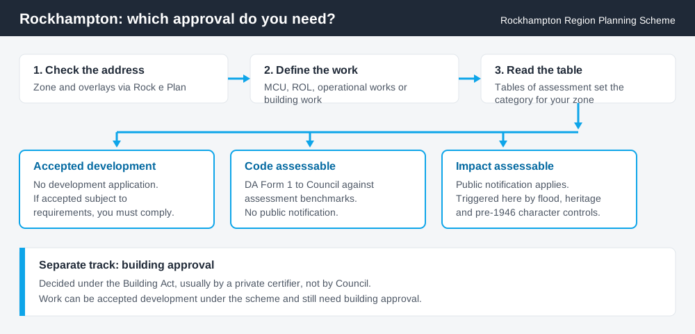
Figure 1: Two tracks run in parallel. Answering one does not answer the other.
The Rockhampton Region Planning Scheme
The scheme commenced on Monday 24 August 2015, replacing the Fitzroy Shire Planning Scheme, the Mount Morgan Shire Planning Scheme and the Rockhampton City Plan. That amalgamation history still shows in how differently the scheme treats the city, the rural areas and Mount Morgan.
It is kept current by amendment rather than replacement. The current version is Version 5, a major amendment that commenced on 28 March 2025 and was adopted in three packages. Council has also completed the ten-year review required under the Planning Act 2016, so this is an area worth checking rather than assuming. A temporary local planning instrument is also in force — TLPI No. 1 of 2025, on renewable energy and battery storage facilities, effective 28 November 2025.
Rockhampton's scheme follows the standard Queensland structure of strategic framework, zone codes, overlay codes and tables of assessment, with Council's own codes layered over it. Schemes are not uniform across the state, so a rule you read for another council will not carry across. What zone is my property in explains that structure.
Two approval tracks, not one
Spend 5 minutes, not 3 weeks
instantDA generates a council-ready planning report for Queensland development applications. No town planner. No waiting.
Get your report →Development approval is a Planning Act 2016 decision. Council is the assessment manager, and it deals with land use, siting, scale and compliance with the scheme's codes.
Building approval is a Building Act decision about whether the structure complies with the building assessment provisions, and it is usually given by a private certifier.
Separate approvals, separate legislation, separate decision-makers. A shed can be accepted development under the scheme and still need building approval, and holding a building approval does not cure a missing development approval. Building approval versus development approval covers the distinction properly.
- ✓What zone applies?
- ✓Which overlays touch the land?
- ✓Is the work assessable or accepted development?
- ✓If accepted, is it accepted subject to requirements?
- ✓Do you also need building approval?
Checking your own address
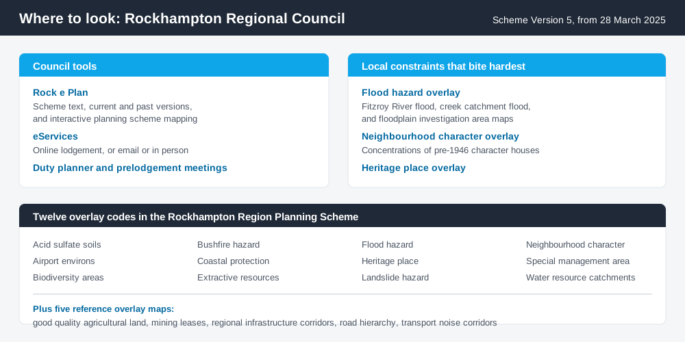
Figure 2: Council's tools, and the overlays most likely to affect a Rockhampton site.
Council's online planning portal is Rock e Plan, which lets you view and search current and previous versions of the scheme alongside interactive planning scheme mapping. Start at rockeplan.rockhamptonregion.qld.gov.au and establish the zone and every overlay before reading any table of assessment.
The scheme carries twelve overlay codes, set out in Figure 2, plus five reference overlay maps covering matters such as good quality agricultural land and mining leases. How to check overlays on your property walks through the method.
For state-administered layers the scheme does not carry, cross-check the site on the Queensland Globe.
What catches Rockhampton owners out
Flood. This is the big one. The flood hazard overlay uses three map types — Fitzroy River flood, creek catchment flood, and floodplain investigation area — and they do different jobs. Council records major Fitzroy River floods in 1918, 1954, 1991, 2008, 2011 and 2013, and creek catchments at North Rockhampton, Bajool, Stanwell and Kabra flooded significantly in January 2013. In high and extreme hazard areas the scheme sets the strictest requirements and does not support new lots; in lower hazard areas development can proceed with flood-resilient construction and raised habitable floor levels. The flood hazard overlay explained covers how these overlays work.
Pre-1946 character housing. The neighbourhood character overlay identifies areas with a concentration of pre-1946 character houses. Where it applies, total demolition or relocation of a pre-1946 dwelling house is impact assessable, and other building work is code assessable. The character overlay explained sets out what that means.
Heritage. Quay Street and East Street hold one of the country's better-preserved nineteenth-century commercial streetscapes, with many individually listed buildings. The heritage place overlay applies to local heritage places and to land adjoining a Queensland heritage place, so a neighbour's listing can affect you even if your own building is not listed.
Rural and mining legacy land. Around Gracemere, Mount Morgan and the grazing country, the good quality agricultural land and mining leases reference maps, the extractive resources overlay and the water resource catchments overlay all shape what is realistic. Mount Morgan's historic mine site carries documented contamination and rehabilitation constraints well beyond the scheme.
When you will probably need a DA
Work that changes the use of land, adds a dwelling, subdivides, sits in a mapped flood hazard area, touches a heritage place or a character area, or exceeds the thresholds in the applicable code is likely to be assessable. Modest domestic work on an unconstrained, flood-free suburban lot is far more often accepted development, subject to any requirements attached to that acceptance.
What to do next
Pull the zone and full overlay list for your address from Rock e Plan, then read the table of assessment for what you intend to do.
If you'd rather see the zone, the overlays and the likely category of assessment for a Rockhampton address gathered in one place, an instantDA planning report does that for $169 — against the $800–$1,500 a town planner typically charges for a preliminary opinion. You can start a report in a few minutes.
Then confirm with Council. Rockhampton Regional Council runs a duty planner service, takes applications through its eServices portal, by email or in person at the Development Advice Centre, and recommends a prelodgement meeting for complex proposals. Fees are set annually — as an anchor, the 2025/2026 development assessment schedule lists $1,276.00 per application for a material change of use for a dwelling house or dwelling unit. Confirm the current figure first.
Frequently asked questions
What is Rockhampton's planning scheme?
How do I check the zoning of a Rockhampton property?
Does the Fitzroy River flood mapping affect my property?
Do I need approval to demolish an old house in Rockhampton?
Is building approval the same as council approval in Rockhampton?
How much does a development application cost in Rockhampton?
Ready to generate your report?
Skip the writing. Get a council-ready planning report in 5 minutes.
Get your report