Key takeaways
- ✓The scheme is the Scenic Rim Planning Scheme 2020, commenced 20 March 2020, current version dated 30 June 2023.
- ✓Council's ePlan is where you find your zone, precinct and overlays and download a property report.
- ✓Landscape and scenic amenity are protected through the strategic framework and zone precincts, not a single overlay.
- ✓Bushfire, landslide and steep slope, and flood overlays are the ones that most often make rural work assessable.
- ✓Council has suspended prelodgement and concept meetings until further notice.
Do You Need Council Approval in Scenic Rim?
You'll usually hear this called a development application, or DA — that's the formal name for council approval under the Planning Act 2016. In the Scenic Rim, Council is the assessment manager for most of them, and the rules it applies come from the Scenic Rim Planning Scheme 2020.
What makes this council distinctive is in its name. The region runs from Tamborine Mountain across to Boonah and Kalbar and up against the Great Dividing Range, wrapped by national parks including Lamington, Main Range and Mount Barney. Scenic amenity is no afterthought here — it sits in the strategic framework and shapes what the Rural Zone will accept.
Get a council-ready planning report in 5 minutes — no planner, no waiting.
Get your report →The short answer
You need a development application when the Scenic Rim Planning Scheme 2020 makes your work assessable for your zone, precinct and overlays. A lot of minor domestic work is accepted development. Building approval is separate and is usually decided by a private certifier, not Council.
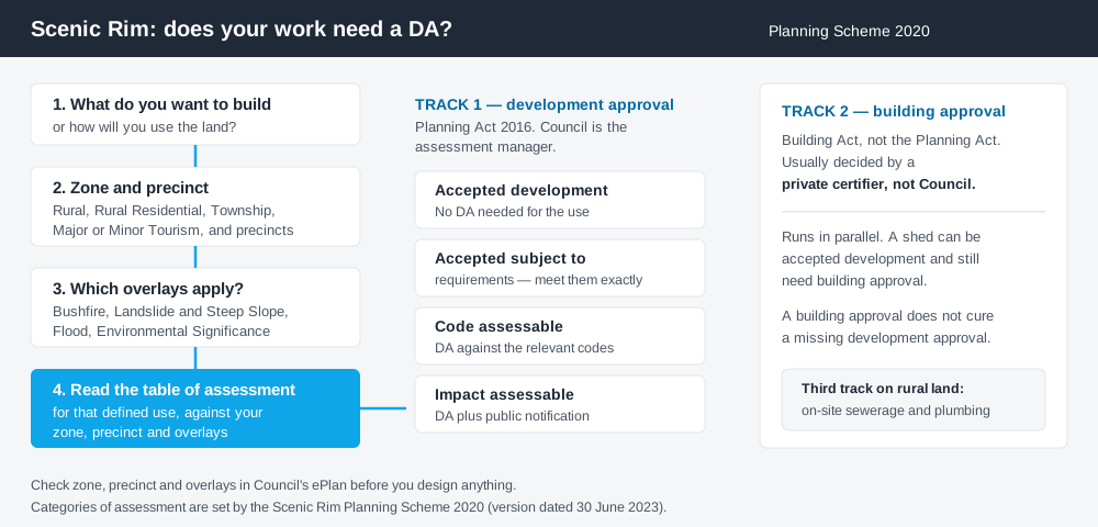
Figure 1: Two tracks run in parallel. Clearing one does not clear the other.
The Scenic Rim Planning Scheme 2020
The scheme commenced on 20 March 2020. The version in force is dated 30 June 2023, folding in Major Amendment No. 3 and Administrative Amendment No. 7 alongside earlier flood mapping amendments for Canungra and Veresdale. Further amendments are in preparation, so a position you checked two years ago may have moved.
It follows the QPP structure — strategic framework, zone codes, overlay codes, tables of assessment — but the codes layered on top are local, and Queensland schemes are far less standardised than people assume.
The zone list tells you what the region is about. Alongside the usual residential and centre zones there is a Major Tourism Zone and a Minor Tourism Zone, and the Rural Zone carries two precincts: the Rural Escarpment Protection Precinct, aimed at very low intensity development protecting regionally significant landscape values, and the Tamborine Mountain Rural Precinct. The Low Density Residential Zone has a Mountain Residential Precinct; the Limited Development Zone has Flood Land and Historical Subdivision precincts.
Two approval tracks, not one
Spend 5 minutes, not 3 weeks
instantDA generates a council-ready planning report for Queensland development applications. No town planner. No waiting.
Get your report →Development approval is a Planning Act 2016 decision. Council is the assessment manager, dealing with land use, siting, scale and compliance with the codes in the scheme.
Building approval is a Building Act decision about whether the structure meets the building assessment provisions, including the QDC. It is usually given by a private certifier.
Separate legislation, separate decision-makers. A farm shed can be accepted development and still need building approval, and a building approval does not cure a missing development approval. Building approval versus development approval sets out the distinction.
On rural land without reticulated services there is usually a third track: on-site sewerage and plumbing work, with your licensed plumber.
- ✓What zone and precinct applies?
- ✓Which overlays touch the lot?
- ✓Is the work accepted, accepted subject to requirements, code assessable or impact assessable?
- ✓Do you also need building approval?
Checking your own address
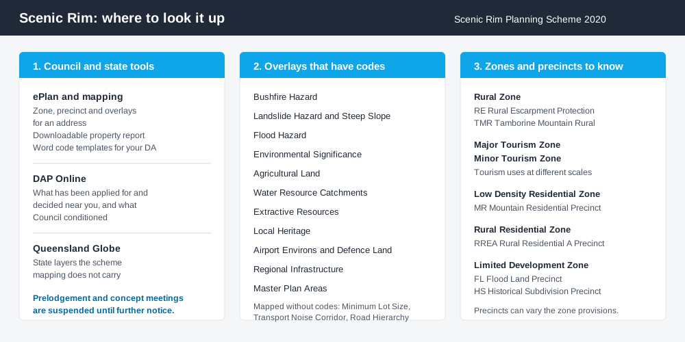
Figure 2: Three lookups, each answering a different question.
Council's ePlan is the interactive planning scheme and mapping platform. Search an address and you can view the zone, precinct and overlays, download a property report bringing it together, and download Word versions of the code templates to fill in when you prepare an application. That last feature is widely missed.
For what has been applied for nearby, Council runs DAP Online, reached from its Development Applications and Planning Online page. Comparable approvals on comparable lots tell you what Council actually conditions, which often beats reading the code text.
Council has suspended prelodgement and concept meeting services until further notice to prioritise applications already under assessment. Get your reading right before you lodge.
Cross-check state layers such as vegetation and protected areas on the Queensland Globe, which covers ground the scheme mapping does not.
What catches Scenic Rim owners out
Overlays on steep, vegetated land. The scheme's overlay codes include Bushfire Hazard, Landslide Hazard and Steep Slope, Flood Hazard, Environmental Significance, Agricultural Land, Water Resource Catchments, Extractive Resources and Local Heritage. On a bushy hillside block, several apply at once. Bushfire hazard overlays explained covers how that assessment runs.
An overlay alone can make a shed assessable. Council's fee register carries a line for a material change of use code assessment "triggered by Overlay only" involving a class 10a domestic outbuilding — $1,060 in the 2026–2027 Register of Fees and Charges, effective 1 July 2026. The zone was never the problem; the overlay was.
Scenic amenity is a real test. The strategic framework asks that non-rural activities be located and designed to preserve the landscape character and scenic amenity of rural areas. In the escarpment precinct, built form is expected to stay low rise and sit below the vegetation canopy.
Rural tourism has limits. Farm stay, cabins and cellar-door uses along the food and wine trail around Boonah and Kalbar are supported where they read as value-adding to a genuine rural operation at a scale suiting the setting. Farm stay and agritourism rules explains the pattern.
Subdivision pressure meets minimum lot sizes. Demand for rural residential lots from Brisbane and the Gold Coast runs straight into a mapped Minimum Lot Size overlay. The Rural residential zone explained is the place to start; see also building on rural land.
When you will probably need a DA
Changing a use, adding a dwelling, reconfiguring a lot, tourist accommodation on rural land, and anything on steep, vegetated, bushfire-prone or flood-affected land is very likely assessable. Modest domestic work on an unconstrained township lot is far more often accepted development, subject to any requirements attached.
What to do next
Pull the property report for your address from the ePlan, list every overlay and precinct, then read the table of assessment for what you intend to build.
If you'd rather see the zone, precinct, overlays and likely category of assessment for a Scenic Rim address in one place, an instantDA planning report does that for $169, against the $800–$1,500 a town planner charges for a preliminary opinion. You can start a report in minutes.
Then confirm with Council. Its planners take confidential enquiries by appointment, and for anything touching the escarpment precincts, bushfire or flood, have that conversation before you engage a designer.
Frequently asked questions
What is the Scenic Rim's planning scheme?
How do I check the zoning of a Scenic Rim property?
Do I need approval for a shed in the Scenic Rim?
Can I run a farm stay on my rural property?
Can I get a prelodgement meeting with Scenic Rim Regional Council?
Where do I look up development applications near me?
Ready to generate your report?
Skip the writing. Get a council-ready planning report in 5 minutes.
Get your report