Key takeaways
- ✓One scheme covers the whole region: Tablelands Regional Council Planning Scheme 2016, Version 5, commenced 9 September 2024.
- ✓Council's interactive planning scheme mapping is where you check zone, local plan and overlays for an address.
- ✓Development approval and building approval are separate. A private certifier usually handles the building side.
- ✓Rural precinct minimum lot sizes are the constraint that most often stops a Tablelands subdivision before it starts.
- ✓Environmental significance, heritage, flood, slope and water resource catchment overlays all bite somewhere in this region.
Do You Need Council Approval in Tablelands Regional?
You'll usually hear this called a development application, or DA — that's the formal name for council approval under the Planning Act 2016. On the Tablelands, Council is the assessment manager for most of them, and the rules it applies come from the Tablelands Regional Council Planning Scheme 2016.
What makes this region distinctive is the land itself. Most of the area is rural, a great deal of it productive agricultural country, and the eastern edge runs into rainforest forming part of the Wet Tropics of Queensland World Heritage Area. Zoning here is rarely the only question.
Get a council-ready planning report in 5 minutes — no planner, no waiting.
Get your report →The short answer
You need a development application when the Tablelands Regional Council Planning Scheme 2016 makes the work assessable for your zone, precinct and overlays. Plenty of minor domestic work is accepted development. Building approval is separate, and is usually issued by a private certifier rather than by Council.
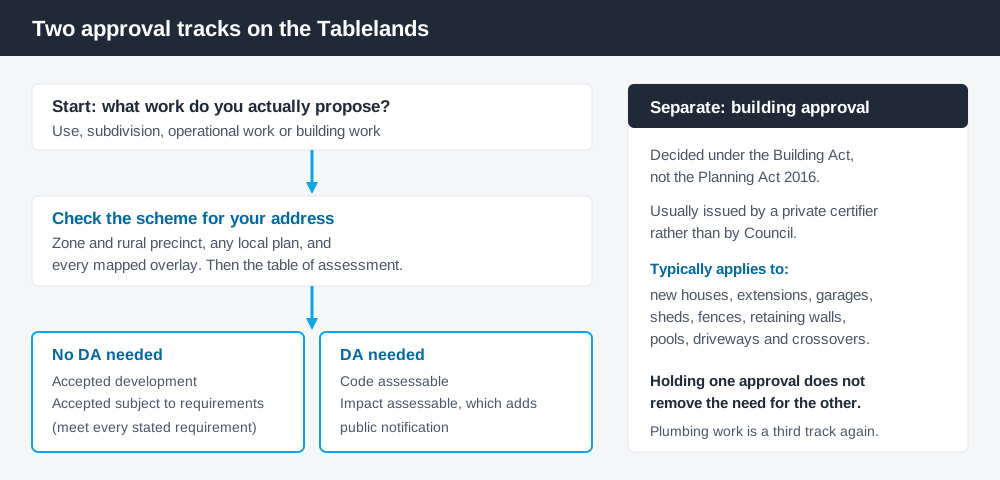
Figure 1: Two tracks run at the same time. Clearing one does not clear the other.
One scheme, not four
The region's history invites confusion. Tablelands Regional Council de-amalgamated in 2014, when Mareeba Shire Council was re-established as a separate council, and Mareeba land is no longer assessed by TRC at all.
What remains is a single consolidated instrument. Council publishes Version 5 of the Tablelands Regional Council Planning Scheme 2016, which commenced on Monday 9 September 2024. The old Atherton, Eacham and Herberton shire schemes are not the operative document — Council's own site describes one scheme applying across the region, issued in three volumes covering the strategic framework and codes, schedules and policies, and mapping.
Like every Queensland scheme it follows the standardised structure used across the state — zones, local plans, overlay codes and tables of assessment — with Council's own codes layered on top. Queensland schemes are far less uniform than people assume, so a rule you read for a neighbouring council will not transfer.
Two approval tracks, not one
Spend 5 minutes, not 3 weeks
instantDA generates a council-ready planning report for Queensland development applications. No town planner. No waiting.
Get your report →Development approval is a Planning Act 2016 decision. Council is the assessment manager. It deals with land use, subdivision, siting, scale, and compliance with the assessment benchmarks in the scheme.
Building approval is a Building Act decision about whether the structure itself complies. Council's guidance is explicit that structural work — a new house, extensions, garages, sheds, fences, retaining walls, pools, driveways — generally needs certification from a private certifier.
Different approvals, different legislation, different decision-makers. Holding one does not cure the absence of the other. Building approval versus development approval sets out the distinction in full.
- ✓What zone and rural precinct applies?
- ✓Is there a local plan over the site?
- ✓Which overlays are mapped?
- ✓Is the work accepted, code assessable or impact assessable?
- ✓Do you also need building approval?
- ✓Does it need referral to the State?
Checking your own address
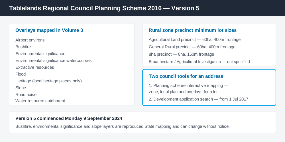
Figure 2: The overlays Council maps, and the two tools that tell you which ones touch your land.
Council runs planning scheme interactive mapping, reached through the interactive mapping page on Council's website after accepting a disclaimer. It carries the zone, local plan, heritage, extractive resources, water resource catchment and priority infrastructure layers Council produces itself, plus reproduced State mapping for bushfire hazard, environmental significance and slope, and flood investigation mapping.
Note the caveat Council attaches: the heritage overlay maps show local heritage places only. State heritage places sit on the Queensland Heritage Register and are regulated separately. In townships such as Herberton and Yungaburra, where much of the older building stock carries character value, that distinction matters before you plan external work.
Council also publishes a development application search covering current applications and decisions from 1 July 2017 onward. What has been approved on comparable land nearby, and on what conditions, is often more useful than reading the code cold. For State layers, cross-check the site on the Queensland Globe. How to check overlays on a Queensland property walks through the method.
What catches Tablelands owners out
Rural minimum lot sizes. This is the big one. Council's guidance on subdividing rural land states minimum lot areas of 60ha with 400m frontage in the Agricultural Land and General Rural precincts, and 8ha with 150m frontage in the 8ha Precinct. Meet the minimum and the application is code assessable; fall below it, or create an additional lot in the Broadhectare or Agricultural Investigation precincts, and you are into impact assessment with public notification. Council says subdivision below the minimum area is not typically supported without exceptional circumstances such as improving agricultural efficiency or resolving a boundary issue. Subdividing rural land and reconfiguring a lot cover the process.
Environmental significance. The overlay is built on mapped national, state and local environmental values, and in a region of rainforest, crater lakes and cassowary country it reaches a lot of land. The biodiversity overlay explains how these codes work.
The other mapped constraints. Flood investigation, slope, bushfire hazard, road noise and water resource catchment overlays all apply somewhere across the region.
Referral to the State. Vegetation clearing, State-controlled road frontage, transmission networks and heritage-listed land can all trigger referral to the State Assessment and Referral Agency.
When you will probably need a DA
Subdividing, changing or intensifying a use, operational work such as earthworks or clearing, and building work on land in a mapped constraint like the flood overlay are the categories that push you into a development application. A modest shed or standard fence on an unconstrained town lot is much more often accepted development — though the building approval question still stands.
What to do next
Run your address through Council's interactive mapping, list the zone, precinct, local plan and every overlay, then read the table of assessment for what you intend to do.
If you'd rather see all of that in one place, an instantDA planning report does it for $169 — against the $800–$1,500 a town planner typically charges for a preliminary opinion. You can start a report in a few minutes.
Then use Council's free pre-lodgement service before committing to a design. Fees change annually: Council's adopted 2026/27 schedule sets a code assessment base application fee of $1,550.00, with impact assessment higher again and reconfiguring a lot adding a per-additional-lot fee. Check the current schedule before you budget.
Frequently asked questions
What is the planning scheme for Tablelands Regional Council?
Does the council still use the old Atherton or Herberton shire schemes?
How do I check the zoning of a Tablelands property?
Can I subdivide rural land on the Tablelands?
Is building approval the same as council approval here?
How much does a development application cost at TRC?
Ready to generate your report?
Skip the writing. Get a council-ready planning report in 5 minutes.
Get your report