Key takeaways
- ✓Moving a boundary is reconfiguring a lot — the Planning Act 2016 dictionary expressly includes rearranging the boundaries of a lot.
- ✓It is a development application to council even though no new lot is created and nothing is built.
- ✓Minimum lot size, frontage and the position of existing buildings against the new boundary are the usual sticking points.
- ✓Approval is only the halfway mark — a licensed surveyor prepares the plan, council endorses it, and the titles office registers it.
- ✓Both registered owners have to be on board, and mortgagee consent is normally required before the plan can register.
Boundary Realignment in QLD
Two neighbours agree the fence has been in the wrong place for forty years. Or one owner wants to buy the strip of land behind the shed. Or a battle-axe handle is too narrow to be useful and the lot beside it has room to spare. In every one of those cases the fix is the same: move the boundary on the title.
That is a formal planning process in Queensland, and it surprises people. No new lot is created, nothing is built, and the total land area does not change — and it still needs council approval.
Get a council-ready planning report in 5 minutes — no planner, no waiting.
Get your report →The short answer
Yes — moving a boundary between lots in Queensland is reconfiguring a lot and needs a development application. The Planning Act 2016 dictionary defines reconfiguring a lot to include rearranging the boundaries of a lot. Approval is followed by a licensed surveyor's plan, council endorsement, and registration with the titles office.
The word to hold onto is reconfiguring. It is the umbrella term, and boundary realignment sits under it alongside subdivision and amalgamation.
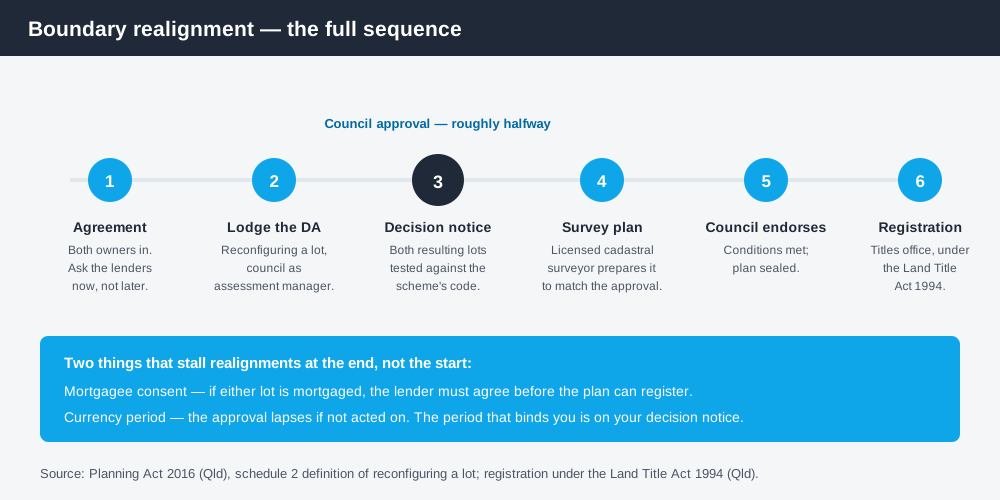
Figure 1: The full sequence — approval is roughly the halfway point.
Why it counts as reconfiguring a lot
Schedule 2, the dictionary, of the Planning Act 2016 defines reconfiguring a lot to include creating a lot by subdividing another, amalgamating two or more lots, and — the relevant one here — rearranging the boundaries of a lot.
The logic is that the boundary is what defines the development potential of a parcel. Change the boundary and you change how much can be built, where it can sit, and what each lot is worth. A council has a legitimate interest in that even when the total land area stays constant.
Whether your particular realignment is code assessable or impact assessable depends on your zone and your council's planning scheme. In most residential zones a straightforward realignment between two conforming lots is code assessable, which is the faster, benchmark-driven pathway. If you are unclear on the difference, accepted versus assessable development in QLD sets out the categories and what each one costs you in time.
What council actually assesses
Spend 5 minutes, not 3 weeks
instantDA generates a council-ready planning report for Queensland development applications. No town planner. No waiting.
Get your report →Council is not deciding whether you and your neighbour agree. It is testing the two lots that will exist after the change against the reconfiguring a lot code in its planning scheme.
- ✓Minimum lot size for the zone — both resulting lots, not just the one you care about
- ✓Minimum road frontage and lot dimensions
- ✓Whether existing buildings still meet setbacks from the new boundary
- ✓Access, services and easements crossing the moved line
- ✓Overlays — flood, bushfire, biodiversity, character, acid sulfate soils
The building setback issue is the one that catches most people. If you shift a boundary towards an existing house, garage or shed, that structure now sits closer to the boundary than it did — and it may no longer comply with the siting standards it was approved against. Councils will notice. The fix is usually to adjust the proposed line, or to seek a siting variation, but it is far cheaper to find out before the survey than after.
The second recurring problem is that one lot ends up under the minimum lot size for its zone. Councils are generally unsympathetic here, because a lot that falls below the minimum is a permanent reduction in the amenity standard the scheme is trying to hold. Minimum lot size in QLD explains how those figures are set and where the exceptions sit.
Survey plan, endorsement and registration
Approval alone changes nothing on your title. The plan does.
After you receive your decision notice, a licensed cadastral surveyor prepares the survey plan showing the new boundaries, consistent with the approval and any conditions on it. That plan then goes back to council for endorsement — commonly called plan sealing — where council confirms the relevant conditions have been met and the plan matches what was approved. Only then is the plan lodged with the titles office for registration, under the Land Title Act 1994, and new title descriptions issue.
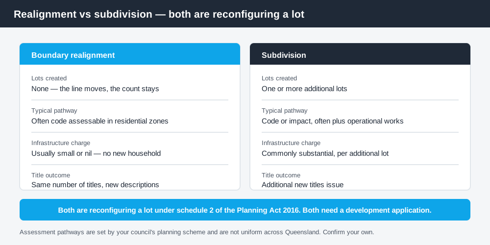
Figure 2: Realignment and subdivision are both reconfiguring a lot, but they behave very differently.
Two practical points sit in this stage. First, both registered owners must be parties — a realignment moves land between titles, so it is a dealing that needs everyone on the titles involved. Second, mortgagee consent is normally required. If either lot is mortgaged, the lender has to agree before the plan can register, and lenders take their own time. Start that conversation early rather than at the end.
Approvals also do not last indefinitely. A development approval has a currency period and lapses if it is not acted on within it. The period that applies to you is stated on your decision notice, so read it rather than relying on a general figure — currency periods in QLD covers how the clock works and what extending it involves. For the surveying and registration mechanics specifically, survey plans in QLD goes deeper than this article does.
Cost and timing, honestly
There are four cost buckets: the council application fee, the surveyor's fee for the plan and any field work, the titles office registration fee, and conveyancing on the transfer of land between the parties. Legal costs are easy to underestimate, because a realignment between two owners is a land transaction as well as a planning one, and it can carry duty implications. Get advice on that from a solicitor before you commit.
Infrastructure charges are usually modest or nil on a straight realignment, because no additional lot and no additional household is created — which is the whole point of the credit system explained in infrastructure charges in QLD. But councils do sometimes levy a charge where the realignment materially changes development potential, so check rather than assume.
On timing, the council decision is only one part. Surveying, endorsement, mortgagee consent and registration all take their own time, and the registration queue is outside anyone's control.
Before you start
Confirm the zone and minimum lot size for both lots, measure where existing buildings will sit against the proposed line, check what overlays apply, and talk to both lenders. You can check zoning, overlays and property boundaries on your council's planning scheme mapping and on the Queensland Globe, the state's free property and spatial mapping tool.
If you would rather see your zone, your overlays and your likely category of assessment in one document before you engage a surveyor, an instantDA planning report does that for your address for $169 — against the $800–$1,500 a town planner typically charges for a preliminary opinion. You can start a report in a few minutes.
Then confirm the final position with your council and a licensed surveyor before you lodge.
Frequently asked questions
Do I need council approval to move a boundary in Queensland?
Is boundary realignment the same as subdivision?
How long does a boundary realignment take in QLD?
Does my neighbour have to agree?
What if my shed ends up too close to the new boundary?
Do I pay infrastructure charges on a boundary realignment?
Ready to generate your report?
Skip the writing. Get a council-ready planning report in 5 minutes.
Get your report