Key takeaways
- ✓Balonne Shire runs the Balonne Shire Planning Scheme 2024, which commenced on 29 January 2024 and replaced the 2019 scheme.
- ✓The scheme has seven zones and a single overlay code — flood hazard — which reflects how much the Balonne River drives planning here.
- ✓There is no online lodgement portal. Applications go to Council by email, in person at St George, or by post.
- ✓The Rural zone's acceptable outcome for new lots is 1,000 hectares, so subdivision expectations are very different from a coastal shire.
- ✓Development approval and building approval are separate. Building approval here can come from Council or a private certifier.
Do You Need Council Approval in Balonne Shire?
You'll usually hear this called a development application, or DA — that's the formal name for council approval under the Planning Act 2016. In Balonne Shire, Council is the assessment manager for most of them, and the rules it applies come from the Balonne Shire Planning Scheme 2024.
What makes Balonne distinctive is how much of the planning question comes down to water. This is Murray-Darling Basin country, the Balonne and Moonie Rivers run through it, and the scheme carries exactly one overlay code — flood hazard. Almost everything else is zone-driven, on lots often measured in thousands of hectares.
Get a council-ready planning report in 5 minutes — no planner, no waiting.
Get your report →The short answer
In Balonne Shire you need a development application when the Balonne Shire Planning Scheme 2024 makes the work assessable for your zone, or when the flood hazard overlay applies to your site. Much minor domestic work is accepted development. Building approval is separate, from Council or a private certifier.
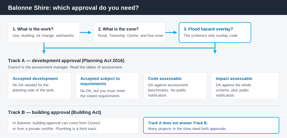
Figure 1: Two tracks run in parallel. Answering one does not answer the other.
The Balonne Shire Planning Scheme 2024
Council adopted the scheme on 18 January 2024, a gazette notice followed on 25 January 2024, and the stated commencement date is 29 January 2024. It replaced the Balonne Shire Planning Scheme 2019, which Council still publishes as superseded — so if you are working from an older PDF, check which one you have.
Queensland schemes follow the Queensland Planning Provisions structure, with each council layering its own codes over the top; they are not standardised in content. Balonne uses seven zones: Centre, General residential, Industry, Recreation and open space, Rural, Rural residential and Township. There is no bushfire or heritage overlay code in it — those layers come through State Planning Policy mapping instead.
Two approval tracks, not one
Spend 5 minutes, not 3 weeks
instantDA generates a council-ready planning report for Queensland development applications. No town planner. No waiting.
Get your report →Development approval is a Planning Act 2016 decision. Council is the assessment manager, and it deals with land use, siting, scale, and whether the proposal meets the assessment benchmarks in the scheme.
Building approval is a Building Act decision about whether the structure itself complies. In Balonne, Council states plainly that building approval can be obtained either from Council or through private certification — worth knowing in a shire where the nearest private certifier may be a long drive away.
They are separate approvals under separate legislation. A shed can be accepted development under the scheme and still need building approval. Holding a building approval does not cure a missing development approval. Building approval versus development approval sets out the distinction in full. Plumbing adds a third track, lodged separately with Council.
- ✓What zone is the land in?
- ✓Does the flood hazard overlay map show the site?
- ✓Is the work assessable or accepted development?
- ✓Is it code assessable or impact assessable?
- ✓Do you also need building approval?
- ✓Does it involve plumbing or on-site sewerage?
Checking your own address
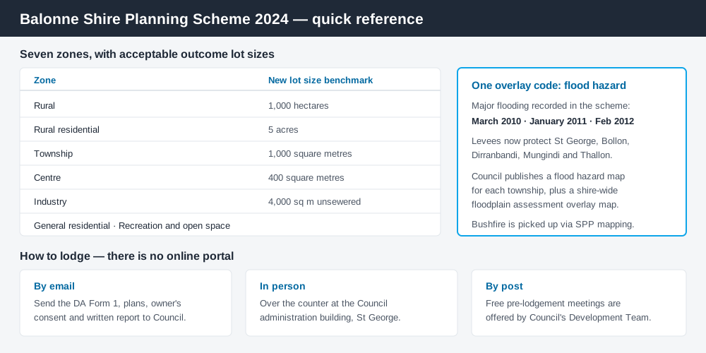
Figure 2: The scheme's zones, the one overlay that matters, and where applications go.
Council publishes an interactive planning scheme map, hosted on ArcGIS, which is the fastest way to establish the zone and whether flood hazard mapping touches your land. It is linked from Council's planning scheme page, alongside downloadable zone and flood hazard maps for each township — St George, Dirranbandi, Thallon, Bollon, Mungindi and Hebel.
Balonne also does something larger councils often do not: it publishes downloadable response tables for each zone code and for the flood hazard overlay code. Filling one out is close to a template for the written part of an application, and it tells you exactly what Council assesses against.
For state layers such as vegetation management, cross-check the site on the Queensland Globe, as How to check overlays explains.
What catches Balonne owners out
Flood. The scheme records major flooding in March 2010, January 2011 and February 2012, with significant impacts on people and property and the evacuation of residents. Levees now protect St George, Bollon, Dirranbandi, Mungindi and Thallon. If your site is shown on the flood hazard overlay map, flood-based assessment applies and the overlay code shapes your design — floor levels first. The flood hazard overlay explained covers how these codes work.
Lot size expectations. The acceptable outcome for new lots in the Rural zone is 1,000 hectares. Rural residential sits at five acres, Township at 1,000 square metres. People arriving from a city assume a rural block can be split; here the benchmark says otherwise unless you justify a performance-based alternative. Minimum lot sizes in Queensland explains how those benchmarks operate.
Irrigated cropping. Cotton is the region's dominant broadacre irrigation crop, supported by the St George irrigation and channel scheme. Earthworks, levees and filling on floodplain land are assessable operational works in their own right, separately from any building. Building on rural land covers that context.
When you will probably need a DA
Work that changes the use of land, adds a dwelling or accommodation, reconfigures a lot, involves earthworks or a levee, or sits on land shown on the flood hazard overlay map is likely to be assessable. Minor domestic work on an unconstrained town block — a modest shed, a standard fence, internal alterations — is far more often accepted development, subject to any requirements attached to that acceptance. The reliable answer comes from the tables of assessment read against your zone, plus the overlay map.
What to do next
Find the zone and check the flood hazard mapping first. Then download the response table for that zone code and read what Council will actually assess.
If you would rather see the zone, the overlay position and the likely category of assessment for a Balonne address pulled together in one place, an instantDA planning report does that for $169 — against the $800–$1,500 a town planner typically charges for a preliminary opinion. You can start a report in a few minutes.
Then talk to Council. Balonne offers free pre-lodgement meetings with its Development Team, and in a shire this size that conversation is quick and worth having before you commission drawings. Applications are lodged by email, over the counter in St George, or by post — there is no online portal. How to lodge a DA in Queensland covers the forms and supporting material.
Frequently asked questions
What is Balonne Shire's planning scheme?
Does Balonne Shire have an online DA portal?
How do I check the zoning of a property in St George or Dirranbandi?
What overlays apply in Balonne Shire?
How much does a development application cost in Balonne Shire?
Can I subdivide a rural block in Balonne Shire?
Ready to generate your report?
Skip the writing. Get a council-ready planning report in 5 minutes.
Get your report