Key takeaways
- ✓Banana Shire's scheme is the Banana Shire Planning Scheme 2021, adopted 23 June 2021 and in effect from 1 July 2021.
- ✓It replaced two older schemes — the Banana Shire Planning Scheme 2005 and the Taroom Shire Planning Scheme 2005.
- ✓Council runs a planning scheme map viewer and a TrueView property report tool at planmap.banana.qld.gov.au.
- ✓Coal, rail, gas and electricity infrastructure each have their own overlay maps across the shire.
- ✓Infrastructure charges are discounted by town: full rate in Biloela and Moura, 56% in Taroom and Theodore, 31% outside the priority infrastructure area.
Do You Need Council Approval in Banana Shire?
You'll usually hear this called a development application, or DA — that's the formal name for council approval under the Planning Act 2016. In Banana Shire, Council is the assessment manager for most of them, and the rules it applies come from the Banana Shire Planning Scheme 2021.
What makes this shire different is scale and spread. One scheme covers Biloela, Moura, Theodore, Taroom, a string of smaller villages and an enormous area of rural land between them. It also sits over working coal country and the electricity infrastructure that serves it, and the scheme maps all of that explicitly.
Get a council-ready planning report in 5 minutes — no planner, no waiting.
Get your report →The short answer
In Banana Shire you need a development application when the Banana Shire Planning Scheme 2021 makes your proposal code assessable or impact assessable for its zone. A good deal of minor work is accepted development. Building approval is a separate process, usually handled by a private certifier.
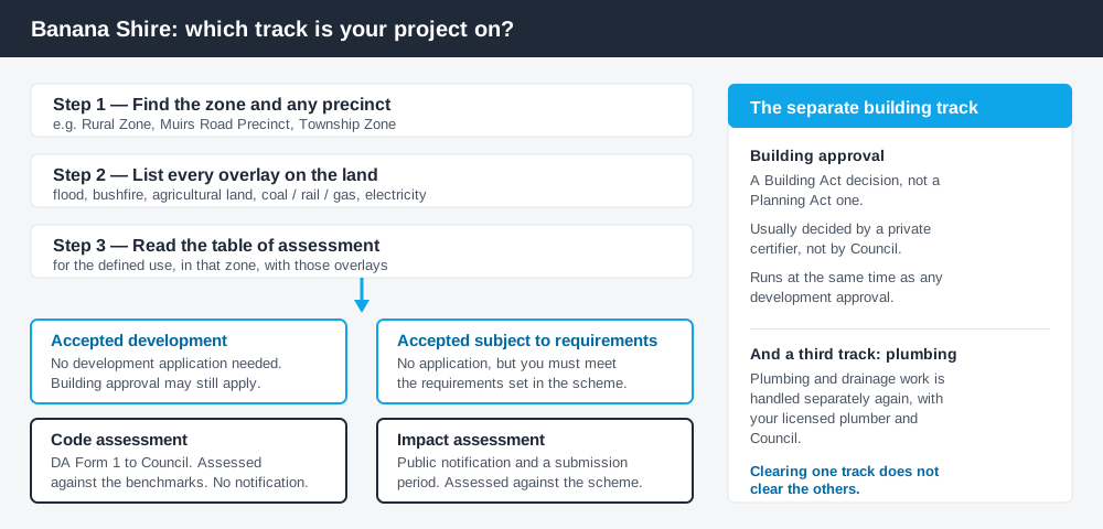
Figure 1: Two tracks run at once. Clearing one does not clear the other.
The Banana Shire Planning Scheme 2021
Council adopted the Banana Shire Planning Scheme 2021 on 23 June 2021, and it has had effect from 1 July 2021. It replaced two documents — the Banana Shire Planning Scheme 2005 and the Taroom Shire Planning Scheme 2005 — which had run side by side since the shires amalgamated. If you are working from a report that names a 2005 scheme, that advice is out of date.
The scheme follows the standard Queensland structure: a strategic framework, tables of assessment, zone codes, development codes and overlay maps. Queensland schemes are not uniform, though — they share that structure, then layer council-specific codes and precincts on top.
The zone list is short by city standards: General Residential, Centre, Recreation and Open Space, Environmental Management and Conservation, Industry, Special Industry, Community Facilities, Mixed Use, Rural, Rural Residential and Township. There is no separate low or medium density residential zone; town residential land generally sits in the General Residential Zone and the villages in the Township Zone. Working out what zone your property is in is the first move on any site.
Two approval tracks, not one
Spend 5 minutes, not 3 weeks
instantDA generates a council-ready planning report for Queensland development applications. No town planner. No waiting.
Get your report →Development approval is the Planning Act 2016 decision. Council is the assessment manager, weighing land use, siting, scale and the assessment benchmarks in the scheme.
Building approval is a Building Act decision about whether the structure itself complies, normally given by a private certifier.
Council's guidance makes the point directly: accepted development does not need a development application, but in most circumstances it will still need building approval through a certifier. The reverse holds too — a building approval does not fix a missing development approval. Building approval versus development approval sets the distinction out properly.
Note too that "accepted development" and "accepted development subject to requirements" are different categories; the second carries requirements you must actually meet.
- ✓What zone is the land in?
- ✓Is it in a precinct such as Muirs Road?
- ✓Which overlays touch it?
- ✓Accepted, code assessable or impact assessable?
- ✓Do you also need building approval?
- ✓Will infrastructure charges apply?
Checking your own address
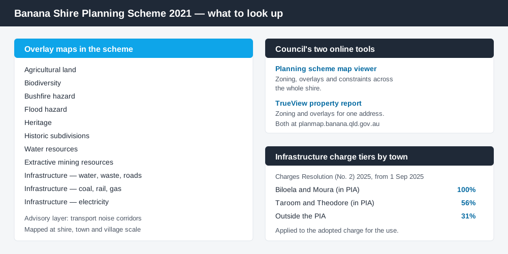
Figure 2: The overlay set Banana Shire actually maps, and where to look an address up.
Council publishes the whole scheme as PDF parts on its planning scheme page, and runs two online tools rather than one combined viewer: an interactive map covering the shire with zoning, overlays and constraints, and TrueView, which reports the zoning and overlays for an individual property. Both sit at planmap.banana.qld.gov.au, and for most owners the property report is the faster route.
For state layers the scheme does not carry — vegetation, mining tenures, protected areas — cross-check the site on the Queensland Globe. Banana Shire has no live application tracker of the kind larger councils run; Council publishes an application approval register by financial year instead, plus notices for applications open for public notification.
What catches Banana Shire owners out
Flood. The scheme carries flood hazard overlay maps at shire, town and village scale, and Council maintains a separate floodplain resolution and flood mapping. This is Dawson River country: Theodore was evacuated in full on 29 December 2010, reported at the time as the first complete evacuation of a Queensland town. How the flood hazard overlay works explains what it changes.
Resource and energy infrastructure. The scheme maps infrastructure overlays in three series — water, waste and roads; coal, rail and gas; and electricity — plus an extractive mining resources overlay. Around Moura and the Callide valley a rural block can pick up several.
The Muirs Road Precinct. This precinct of the Rural Zone is repeatedly carved out of the accepted development categories in the tables of assessment, including for earthworks and some building work. If your land is inside it, the default answer changes.
Big lots, big earthworks. Flood-protection earthworks around a dwelling in the Rural and Rural Residential Zones are accepted only up to limits scaled to lot size, tightening as a proportion of the site as the lot grows. A large holding does not mean a free hand. Building on rural land and rural shed approvals cover the pattern.
Infrastructure charges vary by town. Banana Shire adopts infrastructure charges by resolution, and the rate applied depends on where the land sits — whether it is inside the priority infrastructure area, and which town it serves. Two identical subdivisions in different towns can be charged differently. Take the current rates and the applicable discount from Council's charges resolution before you budget.
When you will probably need a DA
Anything that changes the use of a site, adds dwellings, subdivides, or sits under a hazard or resource overlay is likely to be assessable. Subdivision or boundary realignment leaving a lot below the scheme's minimum lot area is impact assessable, meaning public notification and a submission period. Ordinary domestic work on an unconstrained town lot — a modest shed, a fence, internal alterations — is far more often accepted development, still subject to building approval.
What to do next
Pull the TrueView property report for your address, list every overlay, then read the table of assessment for the use you intend.
If you'd rather see the zone, overlays and likely category of assessment for a Banana Shire address in one place, an instantDA planning report does that for $169, against the $800–$1,500 a town planner charges for a preliminary opinion. You can start a report in minutes.
Then confirm with Council's planning team before you commission drawings. Application fees sit in Council's annual fees and charges schedule and change each financial year, so take the current figure from Council. Infrastructure charges are separate.
Frequently asked questions
What is Banana Shire's planning scheme?
How do I check zoning in Biloela, Moura, Theodore or Taroom?
Do I need council approval for a shed in Banana Shire?
How much are development application fees in Banana Shire?
Ready to generate your report?
Skip the writing. Get a council-ready planning report in 5 minutes.
Get your report