Key takeaways
- ✓Barcoo Shire's scheme is the Barcoo Shire Planning Scheme, which commenced on 2 March 2020.
- ✓There are only two zones shire-wide — Rural and Township — with an Industrial precinct inside Township.
- ✓Flood mapping, not a long list of overlays, is the constraint that shapes most sites here.
- ✓Applications are lodged by email, post or in person at Jundah. There is no online lodgement portal.
- ✓Mining and petroleum activity on resource tenure is a State matter, not a Council development application.
Do You Need Council Approval in Barcoo Shire?
You'll usually hear this called a development application, or DA — that's the formal name for council approval under the Planning Act 2016. In Barcoo Shire, Council is the assessment manager for most of them, and the rules it applies come from the Barcoo Shire Planning Scheme, which commenced on 2 March 2020.
Barcoo is one of Queensland's smallest and most remote local governments. Jundah, Stonehenge and Windorah sit in a shire of very large grazing holdings on the Channel Country floodplain, where the Thomson and Barcoo rivers join above Windorah to form Cooper Creek and drain southwest toward Lake Eyre. That geography does more work in this scheme than zoning does.
Get a council-ready planning report in 5 minutes — no planner, no waiting.
Get your report →The short answer
In Barcoo Shire you need a development application when the Barcoo Shire Planning Scheme makes your proposal assessable for its zone and flood mapping. Much minor rural and domestic work is accepted development. Building approval is a separate approval, usually given by a private certifier rather than Council.
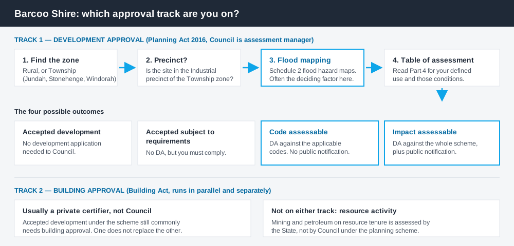
Figure 1: Two tracks run in parallel. Answering one does not answer the other.
A scheme with two zones
Queensland schemes follow the structure set by the Queensland Planning Provisions with council-specific codes layered on top. They are not uniform between councils, and Barcoo shows how far the variation goes.
Most of the shire is in the Rural zone. The three towns are in the Township zone, which contains an Industrial precinct at Jundah and Windorah. That is effectively the whole zoning picture. Where a larger council might run twenty zones and a dozen overlay codes, Barcoo runs two zone codes, a General development code, a Reconfiguring a lot code and an Operational work code.
So the zone alone rarely settles the question. The tables of assessment turn on conditions — whether the use sits inside the Industrial precinct, whether the site is in mapped flood area, whether a threshold is exceeded — more than on which of the two zones you are in. How to find out what zone your property is in covers that structure, and building on rural land in Queensland covers the rural questions that dominate here.
Two approval tracks, not one
Spend 5 minutes, not 3 weeks
instantDA generates a council-ready planning report for Queensland development applications. No town planner. No waiting.
Get your report →Development approval is a Planning Act 2016 decision. Council is the assessment manager, and it deals with land use, siting, scale and compliance with the codes in the planning scheme.
Building approval is a Building Act decision about whether the structure complies with the building assessment provisions, usually given by a private certifier rather than Council. The two remain separate decisions under separate legislation. Building approval versus development approval covers the distinction in full.
- ✓Rural or Township zone?
- ✓Inside the Industrial precinct?
- ✓In mapped flood area?
- ✓Accepted, or assessable?
- ✓Building approval too?
- ✓Any State referral?
Checking your own address
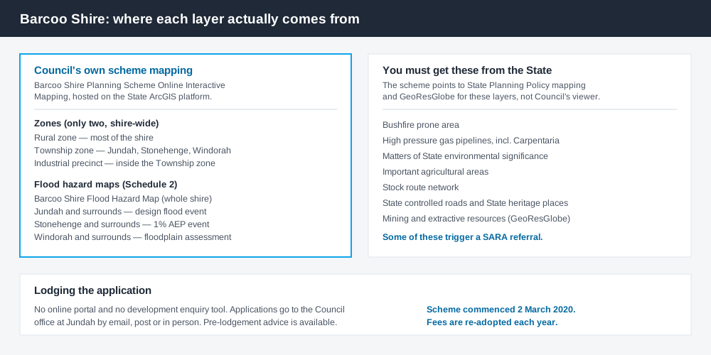
Figure 2: What Barcoo maps itself, and what you have to get from the State.
The scheme lists Barcoo Shire Planning Scheme Online Interactive Mapping, a viewer hosted on the State's ArcGIS platform, carrying the zone layers, the Industrial precinct, the flood mapping and the local government boundary.
The flood layers are worth reading closely. Schedule 2 maps a shire-wide flood hazard map plus separate maps for Jundah, Stonehenge and Windorah. The town layers are refined to specific design flood events — Jundah at 8.38m on the Bureau gauge, Stonehenge to a one per cent annual exceedance probability event at 7.97m — while everything outside them falls back to the Queensland floodplain assessment overlay. Flood hazard overlays in Queensland explains how that mapping changes what you can build and how high.
Several layers the scheme does not map itself: bushfire prone area, high pressure gas pipeline buffers including the Carpentaria Gas Pipeline, matters of State environmental significance, important agricultural areas and the stock route network. Those come from State Planning Policy mapping.
What catches Barcoo landholders out
Flood is the trigger, not a footnote. Across the tables of assessment, being inside mapped flood area is what lifts a proposal out of accepted development. Council's fact sheet notes a flood management plan may be required.
Resource activity is not a Council decision. Oil and gas in the southern half of the shire, and opal and other mining, are regulated under State resource legislation and the Environmental Protection Act, not through a planning scheme. The Channel Country is also a strategic environmental area under the Regional Planning Interests Act 2014, where resource and regulated activities need a State approval. Council's scheme plans around those activities rather than approving them.
No online portal. Barcoo has no electronic lodgement portal and no development enquiry tool. Applications go to the Council office at Jundah, and pre-lodgement advice is available by phone or email. That conversation is worth having early.
When you will probably need a DA
The pattern is reasonably consistent. Work that starts a new use, re-establishes an abandoned one, materially increases the intensity of an existing one, subdivides, or sits in mapped flood area is likely to be assessable. Material change of use in Queensland explains the first three.
Modest work on an unconstrained lot — a farm shed on a large holding, a fence, internal alterations that do not change floor area, height or structure — is much more often accepted development, subject to any attached requirements.
What to do next
Identify your zone and any flood mapping on the interactive viewer, then read the table of assessment for what you intend to do. Council's adopted fees and charges schedule for 2026-27 is on its website — as an anchor, subdividing one allotment into two carries a base fee of $2,415.00. Fees are re-adopted annually, so always take the current figure from Council.
If you would rather see the zone, the mapping and the likely category of assessment for a Barcoo address in one place, an instantDA planning report does that for $169 — against the $800–$1,500 a town planner typically charges for a preliminary opinion. You can start a report in a few minutes.
Then confirm with Council. The Barcoo Shire Council planning scheme page has the current scheme and the lodgement fact sheet.
Frequently asked questions
What is Barcoo Shire's planning scheme?
What zones exist in Barcoo Shire?
How do I lodge a development application in Barcoo Shire?
Does Council approve mining or gas projects?
Is flooding really that significant here?
Is building approval the same as council approval?
Ready to generate your report?
Skip the writing. Get a council-ready planning report in 5 minutes.
Get your report