Key takeaways
- ✓Boulia's scheme is the Boulia Shire Planning Scheme 2020-2040, which commenced on 3 August 2020.
- ✓The scheme has only four zones — Township, Rural residential, Rural, and Recreation and open space.
- ✓There are no overlay codes. Flood comes from the scheme's own Schedule 2 mapping; bushfire comes from state mapping.
- ✓Part of the shire sits in the Channel Country strategic environmental area under the Regional Planning Interests Act 2014.
- ✓Council outsources building and planning assessment, so fees beyond lodgement are quoted case by case.
Do You Need Council Approval in Boulia Shire?
You'll usually hear this called a development application, or DA — that's the formal name for council approval under the Planning Act 2016. In Boulia, Council is the assessment manager, and the rules it applies come from the Boulia Shire Planning Scheme 2020–2040.
Boulia is one of the most remote local governments in Queensland. Council's own scheme describes roughly 61,000 square kilometres, a population of about 425, two towns — Boulia and Urandangi — and an economy of cattle, tourism and mining exploration.
In this guide: how the scheme works, the two approval tracks, how to check an address, and what catches owners out here.
Get a council-ready planning report in 5 minutes — no planner, no waiting.
Get your report →The short answer
In Boulia Shire you need a development application when the Boulia Shire Planning Scheme makes the work assessable for your zone. Much minor work in town is accepted development. Building approval is a separate approval, and Council outsources building certification, so contact Council early.
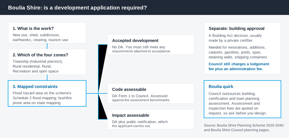
Figure 1: Two tracks run in parallel. Answering one does not answer the other.
The Boulia Shire Planning Scheme
The scheme may be cited simply as the Boulia Shire Planning Scheme. Council adopted it on 21 July 2020 by resolution 2020/7.13, the gazette notice followed on 24 July 2020, and the commencement date was 3 August 2020. It runs to a twenty-year horizon, hence the 2020–2040 range on its cover.
It follows the standardised structure used across Queensland — strategic framework, zones, tables of assessment, codes — but it is a genuinely small scheme. There are only four zones: Township (with an Industrial precinct), Rural residential, Rural, and Recreation and open space. Almost the whole shire is Rural, and almost everything residential sits in the Township zone.
Three codes do the rest: General development, Reconfiguring a lot, Operational work. Queensland schemes share a structure, not content. What zone your property is in covers reading it.
No overlays — the constraints sit elsewhere
Spend 5 minutes, not 3 weeks
instantDA generates a council-ready planning report for Queensland development applications. No town planner. No waiting.
Get your report →The scheme has no overlay codes at all — the most distinctive thing about planning here. Where a city scheme would send you to a flood or bushfire overlay, Boulia's tables of assessment point straight at maps.
Flood runs through the scheme's own Schedule 2 – Flood mapping. Read the tables and the same phrase recurs: a use is accepted development only if it is not located in a flood hazard area on Schedule 2 – Flood mapping. Being in that mapped area is often what moves work from needing no approval to needing one.
Bushfire works differently again — the scheme sends you to state mapping for natural hazards, not a council layer. Flood hazard overlays and bushfire hazard overlays explain how these layers behave.
Two approval tracks, not one
Development approval is a Planning Act 2016 decision. Council is the assessment manager. It deals with land use, siting, scale and compliance with the scheme's codes.
Building approval is a Building Act decision about whether the structure complies with the building assessment provisions, usually given by a private certifier. Council's guidance is direct: approval must be obtained before renovations, alterations or additions, and for carports, gazebos, pools, spas, retaining walls and shipping containers.
Two Boulia-specific points matter. Council outsources building, certification and town planning assessment, and says applications attract further assessment and inspection fees quoted on request. And where a private certifier lodges for you, Council still charges a lodgement fee plus an administration fee. Building approval versus development approval covers the distinction.
- ✓Which of the four zones?
- ✓Flood hazard area on Schedule 2?
- ✓Bushfire prone on state mapping?
- ✓Accepted, or assessable?
- ✓Building approval too?
- ✓Fee quotation from Council?
Checking your own address
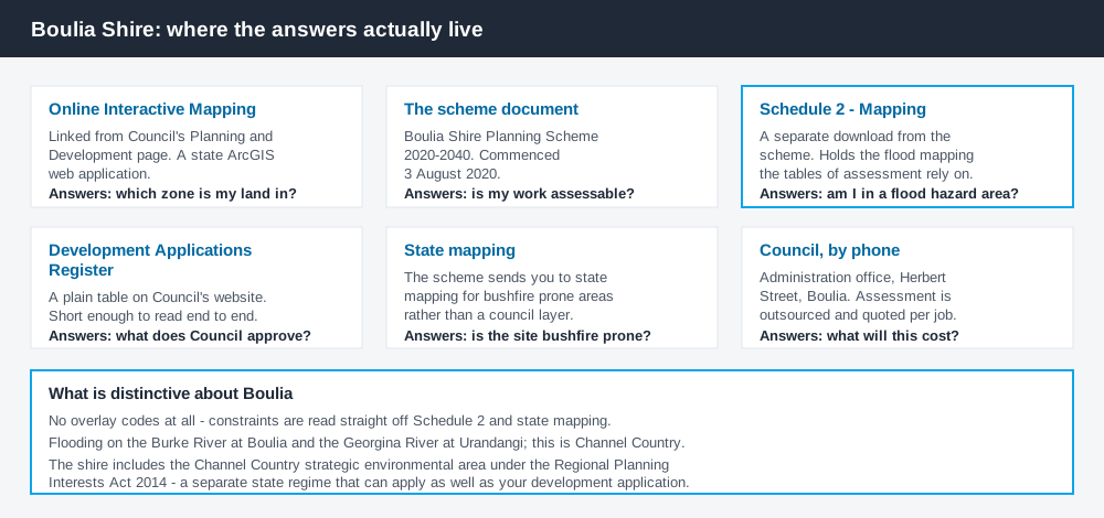
Figure 2: What Boulia publishes, and what each source is actually for.
Boulia does not run an ePlan platform. From its Planning and Development page it links Boulia Shire Planning Scheme Online Interactive Mapping, a state ArcGIS web application, and that is the practical starting point for zoning. Council also publishes the scheme as a document, with Schedule 2 – Mapping as a separate download — and Schedule 2 holds the flood mapping.
Council maintains a Development Applications Register as a plain table on its website. In a shire this size that is unusually useful: you can read all of it in minutes and see what Council actually decides. Sheds, carports, a pool, short-term accommodation, reconfiguring a lot, a solar farm, sand extraction from the Burke River. Some entries needed no Council approval at all.
For state layers, cross-check the site on the Queensland Globe.
What catches Boulia owners out
Flood. Council's strategic framework records a long history of flooding: Boulia sits on the western bank of the Burke River, Urandangi just east of the Georgina, and both are prone to inundation. This is Channel Country — in wet periods vast areas go under and roads close. If your site is in the mapped flood hazard area, assume the category of assessment changes.
The Channel Country strategic environmental area. The scheme states plainly that Boulia Shire includes the Channel Country strategic environmental area identified under the Regional Planning Interests Act 2014 — a separate state regime over resource and other regulated activities. It does not replace your DA; on some projects it applies as well.
Rural scale. Holdings here are very large and almost all in the single Rural zone. "Rural means unregulated" is a mistake — reconfiguring a lot, operational work such as earthworks or clearing, and extractive industry all engage the scheme. Building on rural land covers it.
When you will probably need a DA
Work that starts a new use, materially increases the intensity of an existing one, subdivides or realigns boundaries, alters the shape of the land through earthworks or clearing, or sits in a mapped flood hazard area is likely to be assessable. Tourism is live here — the shire's economy runs on the Min Min light and the Outback Way, and short-term accommodation is a material change of use that has been through the register.
Modest work in town on an unconstrained lot is far more often accepted development, subject to the requirements attached. Sheds on rural land is the most common query here.
What to do next
Get the zone from Council's online interactive mapping, check Schedule 2 flood mapping for the same address, then read the table of assessment for what you intend to do.
If you'd rather see the zone, the mapped constraints and the likely category of assessment for a Boulia address in one place, an instantDA planning report does that for $169 — against the $800–$1,500 a town planner typically charges for a preliminary opinion. You can start a report in a few minutes.
Then call Council. In a shire this small a call to the administration office in Herbert Street beats any amount of reading, and you need a fee quotation anyway. Council's Planning and Development page has the scheme, the mapping link and the register.
Frequently asked questions
What is Boulia Shire's planning scheme?
Does Boulia Shire have online planning maps?
How much does a development application cost in Boulia?
Are there overlays in the Boulia planning scheme?
Ready to generate your report?
Skip the writing. Get a council-ready planning report in 5 minutes.
Get your report