Key takeaways
- ✓Cloncurry runs on the Cloncurry Shire Planning Scheme 2016, currently Version 2 dated 4 July 2017, which commenced on 15 February 2016.
- ✓The scheme has eleven zones and five overlays — airport environs, bushfire hazard, flood hazard, heritage, and waterway corridors, wetlands and biodiversity.
- ✓There is no public online zoning map. Zone and overlay mapping sits in Schedule 2 of the scheme document.
- ✓Applications are lodged directly with Council in person, by email or by post — there is no online lodgement portal.
- ✓Non-resident workforce accommodation has its own code, and the scheme steers it away from the Rural zone.
Do You Need Council Approval in Cloncurry Shire?
You'll usually hear this called a development application, or DA — that's the formal name for council approval under the Planning Act 2016. In Cloncurry, Council is the assessment manager, and the rules it applies come from the Cloncurry Shire Planning Scheme 2016.
Cloncurry sits in the heart of the North West Minerals Province. The scheme's own strategic vision describes a shire sustained by mining, cattle, transport, agriculture and tourism, with specialist mining centres including Ernest Henry, Cannington and Osborne, and residential communities in the Cloncurry Township plus Dajarra and Kajabbi. Copper, grazing, extreme heat and a workforce that comes and goes shape what needs approval here.
In this guide: how the scheme is built, the two approval tracks, how to check an address without an online map, and what catches Cloncurry owners out.
Get a council-ready planning report in 5 minutes — no planner, no waiting.
Get your report →The short answer
You need a development application in Cloncurry Shire whenever the Cloncurry Shire Planning Scheme 2016 makes your proposal assessable for its zone or an overlay. Much modest work in town is accepted development. Building approval is a separate approval, and Council outsources building certification.
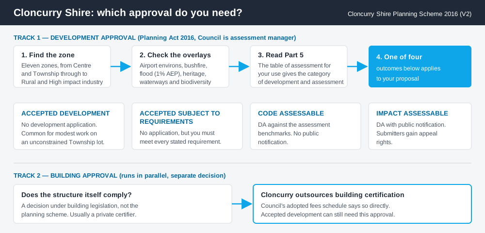
Figure 1: Two tracks run in parallel. Clearing one does not clear the other.
The Cloncurry Shire Planning Scheme 2016
The scheme may be cited as the Cloncurry Shire Planning Scheme 2016. A notice was published in Government Gazette No. 20 on 5 February 2016, and the commencement date was 15 February 2016. The version Council publishes is Version 2, dated 4 July 2017, with amendments in Appendix 2.
It follows the structure used across Queensland — strategic framework, tables of assessment, zones, overlays, development codes — but the content is Cloncurry's own. Schemes here share a shape, not a rulebook. There are eleven zones: Centre, Community facilities, General residential, High impact industry, Limited development (constrained land), Low impact industry, Medium impact industry, Mixed use, Rural, Rural residential and Township. The scheme also advances the North West Regional Plan 2010–2031.
Several use codes here would not appear in a coastal council: extractive industry, intensive animal industry, caretaker's accommodation, and non-resident workforce accommodation. Working out your zone is the first move.
Five overlays, and the ones that bite
Spend 5 minutes, not 3 weeks
instantDA generates a council-ready planning report for Queensland development applications. No town planner. No waiting.
Get your report →Cloncurry's scheme carries five overlay codes: airport environs, bushfire hazard, flood hazard, heritage, and waterway corridors, wetlands and biodiversity.
Flood is the one owners most often meet. The flood hazard overlay code applies to assessable development on land wholly or partly within the overlay and identified as having a 1% AEP on the flood hazard overlay maps in Schedule 2. Its purpose is to minimise risk to life, property, community and environment in future flood events. The Cloncurry River moves a long way in a wet season, and being inside that mapped area changes what you can build and how high the floor sits. Flood hazard overlays covers how these layers work.
The airport environs overlay matters more than its name suggests, and the scheme also flags Defence land beside Cloncurry Airport. The heritage overlay carries the early copper story — Kuridala, Mount Elliott at Selwyn, Mount Cuthbert near Kajabbi.
Two approval tracks, not one
Development approval is a Planning Act 2016 decision. Council is the assessment manager and assesses your application against the planning scheme and relevant state instruments — use, siting, scale, and the assessment benchmarks in the applicable codes.
Building approval is a separate decision under building legislation about whether the structure itself complies, usually given by a private certifier. Council's adopted fees schedule states plainly that building certification is outsourced. A shed can be accepted development under the scheme and still need building approval before a slab is poured. Building approval versus development approval explains it.
- ✓Which of the eleven zones?
- ✓Any of the five overlays?
- ✓Accepted, or assessable?
- ✓Code or impact assessment?
- ✓Building approval as well?
- ✓Pre-lodgement advice booked?
Checking your own address
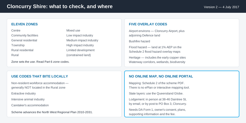
Figure 2: What Cloncurry publishes, and what each source is actually for.
Cloncurry does not run a public online zoning map. There is no ePlan platform and no interactive mapping application. Zone and overlay mapping lives inside Schedule 2 of the scheme, which Council publishes as a single large PDF.
For state layers — vegetation, resource tenures, waterways — cross-check the site on the Queensland Globe; our guide to using it helps if you are new to it.
Council also offers free pre-lodgement advice, generally within about ten working days for a simple enquiry, using its Pre-Lodgement form and a concept plan drawn to scale. In a council this size that is the fastest route to an answer.
What catches Cloncurry owners out
Caravans in the backyard. Council publishes a backyard caravans fact sheet and form, and its fees schedule sets a caravan application fee plus a weekly charge, with conditional approval required where a caravan is occupied on land — including temporary occupation while a dwelling is built. Housing pressure makes this common, and it is not automatic. Caravans on your property has the rules.
Workers' accommodation. Non-resident workforce accommodation has its own code, and the strategic framework says it is generally not located in the Rural zone and should sit within the Cloncurry Township where services exist. A camp on a grazing property is a material change of use with real assessment attached.
Rural does not mean unregulated. Reconfiguring a lot, earthworks, extractive industry and intensive animal industry all engage the scheme. Building on rural land sets out the traps.
When you will probably need a DA
Work that starts a new use or materially intensifies an existing one, subdivides, moves earth, or sits inside a mapped overlay is likely to be assessable. Workers' accommodation, tourism uses, extractive industry and anything in the floodplain are the usual candidates. A modest addition on an unconstrained Township lot is far more often accepted development, subject to the requirements attached.
What to do next
Find your zone in Schedule 2, check the same lot against the flood, bushfire and airport environs maps, then read the table of assessment in Part 5.
If you'd rather see the zone, the mapped constraints and the likely category of assessment for a Cloncurry address in one place, an instantDA planning report does that for $169 — against the $800–$1,500 a town planner typically charges for a preliminary opinion. You can start a report in a few minutes.
Then contact Council. Applications are lodged directly — in person at 38–46 Daintree Street, by email, or by post — with a completed DA Form 1, owner's consent, plans, supporting information addressing the applicable assessment benchmarks, and the fee. Council's Planning Services page has the scheme and the forms.
Frequently asked questions
What is Cloncurry Shire's planning scheme?
Does Cloncurry Shire have online planning maps?
How do I lodge a development application in Cloncurry?
How much does a development application cost in Cloncurry?
What overlays apply in Cloncurry Shire?
Ready to generate your report?
Skip the writing. Get a council-ready planning report in 5 minutes.
Get your report