Key takeaways
- ✓Douglas runs its own scheme — the Douglas Shire Planning Scheme 2018, Version 1.0, which commenced on 2 January 2018. It did not keep a Cairns scheme after de-amalgamation.
- ✓Fourteen zones, ten overlay codes and five local plans. The local plan usually decides the answer, not the zone alone.
- ✓Port Douglas heights are capped by the local plan — three storeys and 13.5 metres in the town centre sub-precinct, two storeys and 8.5 metres elsewhere.
- ✓North of the Daintree River the scheme expects development to be self-sufficient for water, wastewater and electricity.
- ✓Council publishes free Instant Property Reports and a separate Year 2100 storm tide inundation report tool.
Do You Need Council Approval in Douglas Shire?
You'll usually hear this called a development application, or DA — that's the formal name for council approval under the Planning Act 2016. In Douglas Shire, Council is the assessment manager, and the rules it applies come from the Douglas Shire Planning Scheme 2018.
Douglas de-amalgamated from Cairns Regional Council in 2014 and then wrote its own scheme rather than living permanently under a Cairns-era one. It is also, in Council's own words, where "two World Heritage areas meet — the Wet Tropics World Heritage Area and the Great Barrier Reef World Heritage Area."
In this guide: how the scheme is built, the two approval tracks, how to check an address, and what catches Douglas owners out.
Get a council-ready planning report in 5 minutes — no planner, no waiting.
Get your report →The short answer
In Douglas Shire you need a development application when the Douglas Shire Planning Scheme 2018 makes the work assessable for your zone, local plan precinct and overlays. A great deal of ordinary work is accepted development. Building approval is a separate approval, usually given by a private certifier.
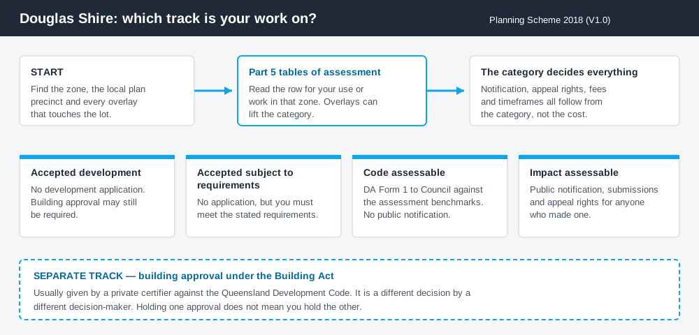
Figure 1: Two tracks run in parallel. Answering one does not answer the other.
The Douglas Shire Planning Scheme 2018
The scheme commenced on 2 January 2018 and is cited throughout its own documents as Version 1.0. Council adopted a Local Government Infrastructure Plan on 5 June 2018, which started on 1 July 2018 as a scheme amendment replacing Part 4. Everything else still runs on Version 1.0.
It follows the standard Queensland pattern — strategic framework, tables of assessment, zones, local plans, overlays, development codes. Queensland schemes share that structure, not their content.
There are fourteen zones, and two of them tell you what this shire is: a Tourism zone and a separate Tourist accommodation zone sit alongside the usual residential, centre, industry, rural, conservation and environmental management zones. Checking what zone your property is in is the first step, but rarely the last one here.
Five local plans and ten overlays
Spend 5 minutes, not 3 weeks
instantDA generates a council-ready planning report for Queensland development applications. No town planner. No waiting.
Get your report →Part 7 contains five local plan codes — Cape Tribulation and Daintree Coast, Coastal Communities, Mossman, Port Douglas/Craiglie, and Return to Country. Each has its own precincts and sub-precincts, and each carries outcomes a zone code alone will not tell you.
Part 8 contains ten overlay codes: acid sulphate soils, bushfire hazard, coastal environment, flood and storm tide hazard, hillslopes, landscape values, natural areas, places of significance, potential landslide hazard, and transport network. On a coastal Port Douglas or Craiglie lot several can apply at once. Storm tide and coastal hazard and acid sulfate soils are the two most commonly underestimated.
Two approval tracks, not one
Development approval is a Planning Act 2016 decision made by Council as assessment manager, about land use, siting, scale and compliance with the scheme's assessment benchmarks.
Building approval is a Building Act decision about whether the structure complies with the building assessment provisions, usually given by a private certifier working to the Queensland Development Code. You can hold one and still be missing the other. Building approval versus development approval sets out the distinction.
Douglas does not run a dedicated online lodgement portal. Applications go on the State DA forms — a material change of use starts with DA Form 1 — and are lodged with Council as assessment manager. Before that, Council runs a Planner of the Day at the customer service counter on Mondays, Wednesdays and Fridays.
- ✓Which of the 14 zones?
- ✓Which local plan precinct?
- ✓Which of the 10 overlays?
- ✓Storm tide level for the lot?
- ✓Accepted, or assessable?
- ✓Building approval too?
Checking your own address
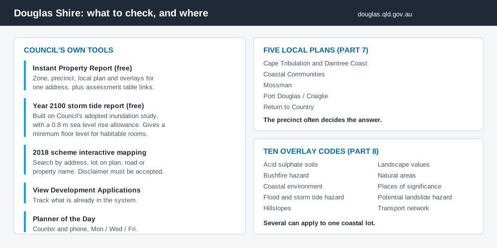
Figure 2: What Douglas publishes, and what each tool is actually for.
Council's mapping is better than the size of the shire would suggest. The free Instant Property Report returns the zones, precincts, local plans and overlays for one address, with links to the relevant assessment tables. A separate free Year 2100 Storm Tide Inundation Mapping Report, built on Council's adopted inundation study, includes a 0.8 metre sea level rise allowance and gives a minimum finished floor level for habitable rooms. Interactive mapping for the 2018 scheme sits behind a disclaimer you must accept, and a View Development Applications service lets you track what is in the system.
For state layers — vegetation, protected areas, the World Heritage boundaries — cross-check on the Queensland Globe.
What catches Douglas owners out
Port Douglas height limits are real and they sit in the local plan. The Port Douglas/Craiglie code caps buildings in the Town Centre sub-precinct at three storeys and 13.5 metres, inclusive of roof height, with other sub-precincts held to two storeys and 8.5 metres. The stated reason: buildings must "remain subservient to the natural environment and the backdrop of Flagstaff Hill." Building height rules explains how these are measured.
North of the Daintree River, services are your problem. The Cape Tribulation and Daintree Coast local plan expects development to be self-contained through on-site rain water collection and storage, sewerage treatment and electricity generation, and asks for an "environmentally acceptable and energy efficient power supply" screened from the road. It also ties development scale to the vehicular capacity of the Daintree River ferry crossing and the Alexandra Range road.
Short-term accommodation is a use, not a lifestyle choice. Letting a Port Douglas dwelling out to visitors can be a material change of use depending on the zone, the precinct and the existing approval. Short-stay accommodation rules covers where the line falls.
Some Council web pages are dated. The development application overview page still refers to the repealed Sustainable Planning Act 2009 and a 2008 scheme. The operative instrument is the 2018 scheme under the Planning Act 2016.
When you will probably need a DA
Work that starts a new use, materially increases the intensity of an existing one, subdivides, exceeds a local plan height outcome, or triggers an overlay code is likely to be assessable. Modest work on an unconstrained inland lot is far more often accepted development, subject to the requirements attached.
What to do next
Pull the free Instant Property Report for the address, then the storm tide report, then read the local plan precinct before the zone code.
If you'd rather see the zone, the precinct, the mapped constraints and the likely category of assessment in one place, an instantDA planning report does that for $169 — against the $800–$1,500 a town planner typically charges for a preliminary opinion. You can start a report in a few minutes.
Then talk to the Planner of the Day. Council's planning scheme page has every part of the scheme as a download.
Frequently asked questions
What planning scheme applies in Douglas Shire?
Is there a building height limit in Port Douglas?
How do I lodge a development application with Douglas Shire Council?
What does a development application cost in Douglas Shire?
Do I need approval to build north of the Daintree River?
Ready to generate your report?
Skip the writing. Get a council-ready planning report in 5 minutes.
Get your report