Key takeaways
- ✓Flinders runs the Shire of Flinders Planning Scheme 2017, adopted 19 September 2017 and commenced 2 October 2017.
- ✓Version 1.1 took effect on 28 February 2018 and is the version Council publishes today.
- ✓The scheme has eleven zones and six overlays — biodiversity, bushfire hazard, flood hazard, heritage, major infrastructure, and wetland and waterway corridor.
- ✓Building work not tied to a material change of use is accepted, except inside the Major infrastructure or Heritage overlay.
- ✓Large wind and solar projects are now assessed by the State, not by Council, under 2025 legislation.
Do You Need Council Approval in Flinders Shire?
You'll usually hear this called a development application, or DA — that's the formal name for council approval under the Planning Act 2016. In Flinders Shire, Council is the assessment manager, and the rules it applies come from the Shire of Flinders Planning Scheme 2017.
Flinders covers 41,538 square kilometres of North West Queensland, most of it cattle country, with Hughenden at the geographic centre straddling the Flinders River where the Flinders and Hann Highways meet. Prairie, Torrens Creek and Stamford are the smaller villages, Porcupine Gorge and White Mountains national parks sit inside the shire, and the Flinders Discovery Centre anchors the Hughenden leg of Australia's Dinosaur Trail.
In this guide: how the scheme works, the two approval tracks, how to check an address, and what catches owners out.
Get a council-ready planning report in 5 minutes — no planner, no waiting.
Get your report →The short answer
In Flinders Shire you need a development application when the Shire of Flinders Planning Scheme 2017 makes your work assessable for its zone. Plenty of building work is accepted development here. Building approval is a separate approval under different legislation, and both may apply to the same job.
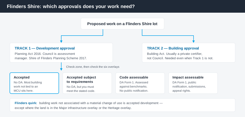
Figure 1: Two tracks run in parallel. Answering one does not answer the other.
The Shire of Flinders Planning Scheme 2017
Council resolved to adopt the scheme on 19 September 2017, and it commenced on 2 October 2017, replacing the Flinders Shire Council Planning Scheme 2005. Minor Amendment No. 1 was adopted on 13 February 2018 and took effect on 28 February 2018, correcting a mapping error. The document Council publishes is therefore Version 1.1 — 28 February 2018.
The scheme follows the standard Queensland structure — strategic framework, zones, tables of assessment, codes and overlays — but Queensland schemes share that structure, not their content. Flinders has eleven zones: Community facilities, Centre, Conservation, General residential, Low impact industry, Medium impact industry, Recreation and open space, Rural, Rural residential, Special purpose and Township. Almost the whole shire is Rural. What zone your property is in covers reading the maps.
The six overlays that actually bite
Spend 5 minutes, not 3 weeks
instantDA generates a council-ready planning report for Queensland development applications. No town planner. No waiting.
Get your report →There are six overlay codes: Biodiversity, Bushfire hazard, Flood hazard, Heritage, Major infrastructure, and Wetland and waterway corridor. An overlay can lift the category of assessment above what the zone alone would give you.
Flood hazard is mapped on overlay maps FL-001 and FL-002 at the 1 in 100 year annual recurrence interval, and applies to material change of use, reconfiguring a lot and operational work. Hughenden sits on the Flinders River, so this is the layer most likely to change your answer. Flood hazard overlays explains how they behave.
Major infrastructure is the one outsiders miss. It is mapped across three council layers — electrical infrastructure, stock routes and road hierarchy — and also picks up State Planning Policy layers for state-controlled roads, railway, transport noise corridors and aviation facilities. In a shire built around two highways, a rail line, an airport and long-standing stock routes, that overlay reaches a lot of frontages. Noise corridors covers the transport side.
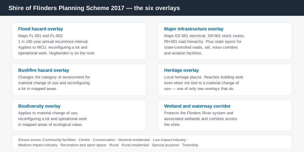
Figure 2: The six overlay codes, and the mapping each one draws on.
Two approval tracks, not one
Development approval is a Planning Act 2016 decision. Council is the assessment manager, dealing with land use, siting, scale and the scheme's codes.
Building approval is a Building Act decision about whether the structure meets the building assessment provisions, usually given by a private certifier rather than Council. Building approval versus development approval sets out the split.
Flinders has one clause worth knowing by heart: building work not associated with a material change of use is accepted development, except where it falls inside the Major infrastructure overlay or the Heritage overlay. So a shed on an unconstrained Rural lot very often needs no development approval at all — but it still needs building approval, and the overlay check is not optional.
- ✓Which of the eleven zones?
- ✓Inside the flood hazard overlay?
- ✓Inside the major infrastructure overlay?
- ✓Heritage place?
- ✓Accepted, or assessable?
- ✓Building approval as well?
Checking your own address
Flinders does not run an online lodgement portal or an ePlan platform. Council publishes the scheme, including its zone and overlay maps, as a document from its Building, Plumbing and Compliance page, and applications go to the Council office at 34 Gray Street, Hughenden. Ring (07) 4741 2900 before you lodge — in a shire this size one call beats an afternoon of reading.
For state layers — vegetation, state-controlled roads, noise corridors, protected areas — cross-check the site on the Queensland Globe.
What catches Flinders owners out
Earthworks. Excavation and filling is code assessable if it is within the flood hazard overlay, or in any zone other than Rural, or exceeds 10,000 tonnes. Separately, excavation and filling in the Rural zone for urban purposes disturbing more than 2,500 square metres is code assessable. Dam and irrigation earthworks on grazing country cross those thresholds faster than people expect. Operational works covers the category.
Renewables. Under the Planning (Social Impact and Community Benefit) and Other Legislation Amendment Act 2025, large-scale wind, solar and battery projects are impact assessable and assessed by the State Assessment and Referral Agency rather than Council. Developers must complete a social impact assessment and enter a community benefit agreement with Council before lodging, and Council adopted a Renewable Energy Community Benefit Framework Policy in February 2026. If you are a neighbour rather than a proponent, your say arrives through public notification.
Rural scale. "Rural means unregulated" is the standard mistake. Reconfiguring a lot, extractive industry, intensive agriculture tied to the Flinders River irrigation proposals, and tourism uses along the Dinosaur Trail all engage the scheme. Building on rural land covers it in detail.
When you will probably need a DA
Work that starts a new use, materially intensifies an existing one, subdivides or realigns boundaries, moves significant earth, or sits in the flood hazard or major infrastructure overlay is likely to be assessable. Council's fees schedule is published with its rates and charges, and material change of use fees are calculated per 100 square metres of total use area.
What to do next
Get the zone from the scheme's zone maps, check the same address against the flood and major infrastructure overlay maps, then read the table of assessment for what you intend to do.
If you'd rather see the zone, the mapped constraints and the likely category of assessment for a Flinders address in one place, an instantDA planning report does that for $169 — against the $800–$1,500 a town planner typically charges for a preliminary opinion. You can start a report in a few minutes.
Then call Council. The Building, Plumbing and Compliance page has the scheme and the amendment history.
Frequently asked questions
What is Flinders Shire's planning scheme?
Do I need council approval for a shed in Flinders Shire?
Does Flinders Shire have an online lodgement portal?
How much does a development application cost in Flinders Shire?
Who assesses wind and solar farms in Flinders Shire?
Ready to generate your report?
Skip the writing. Get a council-ready planning report in 5 minutes.
Get your report