Key takeaways
- ✓The scheme is the Fraser Coast Planning Scheme 2014, commenced 28 January 2014 and still current, with a review project under way.
- ✓Council's online mapping system shows the zone and overlays for an address; PD Online shows applications and approvals.
- ✓Development approval and building approval are separate. One does not substitute for the other.
- ✓The Fraser and Great Sandy Strait Islands overlay makes much ordinary development on K'gari impact assessable.
- ✓Maryborough's character and demolition controls and Mary River flood mapping are the constraints that surprise owners most.
Do You Need Council Approval on the Fraser Coast?
You'll usually hear this called a development application, or DA — that's the formal name for council approval under the Planning Act 2016. On the Fraser Coast, Fraser Coast Regional Council is the assessment manager for most of them, and the rules it applies come from the Fraser Coast Planning Scheme 2014.
One scheme has to cover two very different places plus an island. Hervey Bay is a low-rise coastal city facing storm tide and erosion along its esplanade. Maryborough is a river port with Victorian, Federation and interwar streetscapes and a long history of Mary River flooding. K'gari sits offshore under its own overlay.
Get a council-ready planning report in 5 minutes — no planner, no waiting.
Get your report →The short answer
You need a development application when the Fraser Coast Planning Scheme 2014 makes your work assessable for its zone and overlays. Much minor domestic work is accepted development. Building approval is a separate process, usually decided by a private certifier rather than Council.
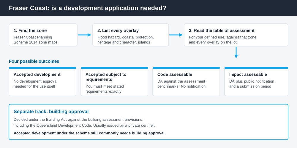
Figure 1: Two tracks run in parallel. Answering one does not answer the other.
The Fraser Coast Planning Scheme 2014
Council adopted the scheme on 22 January 2014, it was gazetted on 24 January 2014, and it commenced on 28 January 2014. It remains the official planning document for the region and sets out Council's intentions for development to 2031. It has not been replaced — but it has been amended repeatedly, the published parts carry a version number, and Council has since run a Planning Scheme Review Project with a first amendment package that went out for public consultation. Take the current position from Council's own site, not a saved PDF.
Like every Queensland scheme, it follows the Queensland Planning Provisions structure — strategic framework, zones, overlays, development codes, tables of assessment — with Fraser Coast codes layered on top. Queensland schemes are not uniform, so a rule from a neighbouring council does not carry across. How to find out what zone your property is in covers that structure.
Two approval tracks, not one
Spend 5 minutes, not 3 weeks
instantDA generates a council-ready planning report for Queensland development applications. No town planner. No waiting.
Get your report →Development approval is a Planning Act 2016 decision. Council is the assessment manager. It deals with land use, siting, scale and compliance with the assessment benchmarks in the scheme.
Building approval is a Building Act decision about whether the structure complies with the building assessment provisions, measured against the Queensland Development Code. It is usually given by a private certifier, not by Council.
Separate legislation, separate decision-makers. A shed can be accepted development under the scheme and still need building approval, and holding a building approval does not cure a missing development approval. Building approval versus development approval sets out the distinction in full. Plumbing adds a third track, handled by your licensed plumber with Council's plumbing team.
- ✓What zone applies to the address?
- ✓Which overlays touch the lot?
- ✓Is the work accepted, accepted subject to requirements, code assessable or impact assessable?
- ✓Do you also need building approval?
- ✓Is there plumbing work?
Checking your own address
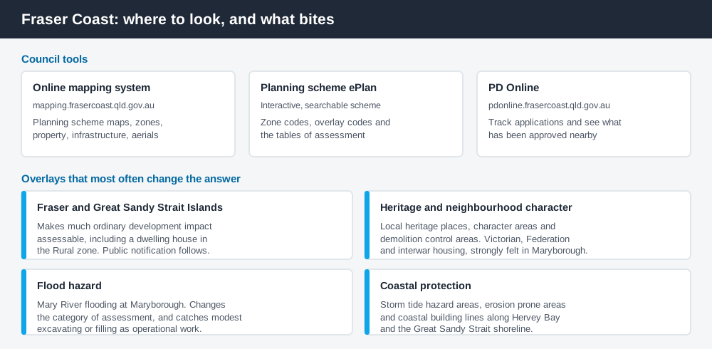
Figure 2: Three Council tools, doing three different jobs.
Council runs an online mapping system at mapping.frasercoast.qld.gov.au, a set of spatial layers covering property and land information, infrastructure, planning zones and aerial photography. It carries the current planning scheme maps, and separately the maps for the proposed amendment package.
The scheme text is published two ways: an interactive, searchable ePlan, and a PDF set part by part. The ePlan is faster once you know your zone.
PD Online at pdonline.frasercoast.qld.gov.au lets you view development information and track applications. What has been approved on comparable nearby sites, and the conditions attached, often tells you more than the code text does.
What catches Fraser Coast owners out
The Fraser and Great Sandy Strait Islands overlay. The region's most distinctive control, and a severe one. Where it applies, development that would be routine on the mainland becomes impact assessable — including a dwelling house in the Rural zone, and reconfiguring a lot creating a lot under 2,000m² in the Low density residential zone. That means public notification and a submission period. Note too that most of K'gari is State-managed national park and World Heritage area, not land the scheme controls; Council's role concentrates on the freehold and leasehold township land.
Maryborough's character and demolition controls. The Heritage and neighbourhood character overlay covers local heritage places, neighbourhood character areas and demolition control areas. Demolishing, relocating or removing a Victorian, Federation or interwar dwelling house triggers assessment, and where the building is visible from the street the overlay can push it to impact assessment. Extensions forward of the front building alignment, enclosing a front verandah, changing external cladding on a front or side elevation, or building a garage or carport can all be caught. The heritage overlay explained covers these controls.
Mary River flooding. Flooding at Maryborough is a defining local constraint, driven by rainfall across a very large upstream catchment, and Council maintains flood mapping and gauge information for it. The Flood hazard overlay changes the category of assessment for a material change of use in a flood hazard area, and catches operational work involving even modest excavating or filling. The flood hazard overlay covers what that means for a design.
Coastal hazard along Hervey Bay. The Coastal protection overlay maps storm tide hazard areas, erosion prone areas and coastal building lines. New buildings, increases in floor area, and building work for a dwelling house or dual occupancy in a mapped storm tide area are all picked up. Storm tide and coastal hazard covers the approach.
When you will probably need a DA
Work that changes the use of a property, adds a dwelling, subdivides, sits in a flood, coastal or islands overlay, or touches a character or heritage listed building is likely to be assessable. Minor domestic work on an unconstrained suburban lot is much more often accepted development, subject to any requirements attached to that acceptance. The only reliable answer comes from the table of assessment for your defined use, read against your zone and every overlay on the lot.
What to do next
Map the address, list every overlay, then read the table of assessment for what you intend to build. Confirm fees against Council's schedule of fees and charges, reissued annually.
If you'd rather see the zone, the overlays and the likely category of assessment for a Fraser Coast address pulled together in one place, an instantDA planning report does that for $169 — against the $800–$1,500 a town planner typically charges for a preliminary opinion. You can start a report in a few minutes.
Then talk to Council's development and planning team — for anything involving the islands overlay, Maryborough character controls or flood mapping, before you engage a designer.
Frequently asked questions
What is the Fraser Coast planning scheme?
How do I check the zoning of a Fraser Coast property?
Why is development on K'gari treated differently?
What does Maryborough's character overlay control?
Ready to generate your report?
Skip the writing. Get a council-ready planning report in 5 minutes.
Get your report