Key takeaways
- ✓Gladstone's scheme is Our Place Our Plan, currently Version 2.1, with an administrative amendment commencing 9 March 2026.
- ✓Council is not always the assessment manager — the Coordinator-General, Gladstone Ports Corporation and Economic Development Queensland each control defined areas.
- ✓The Coastal hazard overlay sets the high storm tide level at 2m above the highest astronomical tide, including an 0.8m sea level rise allowance.
- ✓Development approval and building approval are separate. A private certifier handles most building work.
- ✓Council's online mapping shows zone and overlays for an address, and applications lodge through Council's online system.
Do You Need Council Approval in Gladstone?
You'll usually hear this called a development application, or DA — that's the formal name for council approval under the Planning Act 2016. In the Gladstone region the rules come from Gladstone Regional Council's planning scheme, branded Our Place Our Plan.
But Gladstone has a wrinkle few Queensland councils share. Council itself says development here is managed by both state and local authorities depending on where the land sits — and for a meaningful slice of the region, Council is not the decision-maker.
Get a council-ready planning report in 5 minutes — no planner, no waiting.
Get your report →The short answer
In the Gladstone region you need a development application when Our Place Our Plan makes the work assessable for your zone and overlays. First confirm Council is even the assessment manager — inside the Gladstone State Development Area, on strategic port land, or in a priority development area, someone else decides.
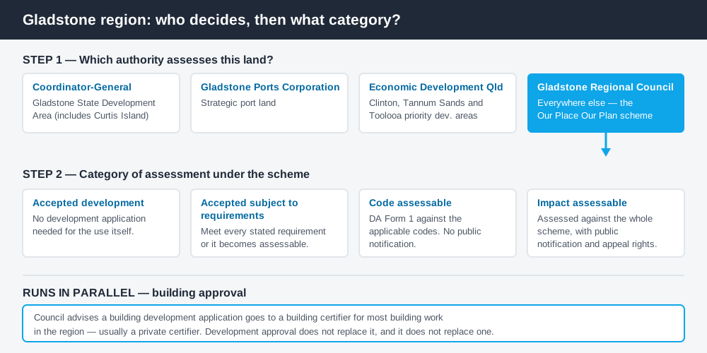
Figure 1: "Who assesses this?" comes before "is it assessable?"
Our Place Our Plan
The scheme commenced on 12 October 2015 and has been amended since rather than replaced. Version 2.1 commenced on 1 December 2025, replacing Version 2, and an administrative amendment to Version 2.1 commenced on 9 March 2026.
It follows the standard Queensland structure — strategic framework, zone codes, overlay codes, tables of assessment — with Council's own codes layered over it. Queensland schemes are not uniform, so a rule you read for another council will not transfer.
Gladstone runs twenty-six zones. Alongside the familiar residential ones, the region uses a Township zone for its smaller settlements, Major and Minor tourism zones, and three industry zones plus an Industry investigation zone — a reflection of an economy built on heavy industry. How to find out what zone your property is in explains reading that structure.
Thirteen overlays sit over the top, including acid sulfate soils, airport environs, biodiversity, bushfire hazard, coastal hazard, extractive resources and minerals, flood hazard, hazardous activities, heritage, regional infrastructure and steep land.
Who assesses your land
Spend 5 minutes, not 3 weeks
instantDA generates a council-ready planning report for Queensland development applications. No town planner. No waiting.
Get your report →Council oversees most land use, but names four other authorities on its own planning schemes page.
The Coordinator-General is responsible for land use within the Gladstone State Development Area — not a variation on the council scheme but a different statutory framework. Development inside a declared state development area is regulated by that area's development scheme under the State Development and Public Works Organisation Act 1971, and an SDA application goes to the Coordinator-General. The Gladstone SDA was extended to take in Curtis Island, where the LNG plants sit.
Gladstone Ports Corporation manages land use on strategic port land. Economic Development Queensland oversees three priority development areas — Clinton, Tannum Sands and Toolooa — where the council scheme does not set the benchmarks. The State Assessment and Referral Agency assesses large-scale wind and solar projects. Establish which framework your lot falls in before you read a single code.
Two approval tracks, not one
Development approval is a Planning Act 2016 decision. Where Council is the assessment manager, its Planning Services team assesses material change of use and reconfiguring a lot applications. What a material change of use means covers that trigger.
Building approval is a separate Building Act decision. Council states that a building development application must go to a building certifier for most building work in the region — usually a private certifier. Holding one does not give you the other. Building approval versus development approval sets out the distinction.
- ✓Which authority controls this land?
- ✓What is the zone?
- ✓Which overlays apply?
- ✓Is the work accepted, accepted subject to requirements, code assessable or impact assessable?
- ✓Do you also need building approval?
Checking your own address
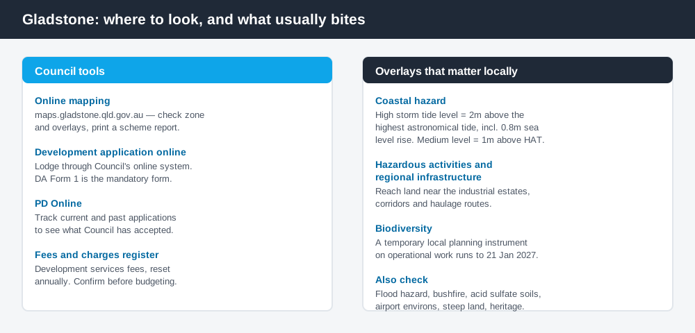
Figure 2: Council's tools, and the overlays that bite hardest.
Council's online mapping is where you check zone and overlays and print a planning scheme report. Applications lodge through Council's online development application system, using DA Form 1 as the mandatory approved form, with the fee and a statement of how the proposal addresses the planning scheme. Council's PD Online tool tracks what has been applied for nearby. For state layers the scheme does not carry, cross-check the Queensland Globe.
What catches Gladstone owners out
Storm tide. The Coastal hazard overlay defines the high storm tide level as 2m above the highest astronomical tide, including an 0.8m sea level rise allowance; the medium level is 1m above it. Habitable rooms are expected to sit at least 1000mm above the high storm tide level, and sensitive uses are steered out of high and medium inundation areas. Around the harbour, Boyne Island, Tannum Sands and Agnes Water this drives floor levels before design starts. Storm tide and coastal hazard explains the mechanics.
The industrial overlays. Hazardous activities, regional infrastructure and extractive resources overlays exist because of what Gladstone does for a living. They reach residential land near the industrial estates and haulage routes.
Biodiversity clearing. A temporary local planning instrument on operational work in the Biodiversity overlay took effect on 24 January 2025 and runs to 21 January 2027 unless repealed sooner. Where it conflicts with the scheme, it prevails.
Front setbacks. Council takes applications for dwelling houses closer than 6m to the front boundary. How to check overlays helps you find the rest.
When you'll probably need a DA
Work that changes the use of land, adds a dwelling, subdivides, sits in a coastal hazard or flood area, involves clearing under the Biodiversity overlay, or exceeds a code threshold is likely assessable. Modest domestic work on an unconstrained lot is much more often accepted development. The table of assessment for your defined use, read against your zone and overlays, is the only reliable answer. Fees sit in Council's fees and charges register and change annually.
What to do next
Print the planning scheme report for your address from Council's online mapping, list every overlay, and confirm which authority controls the land.
If you'd rather see the zone, the overlays and the likely category of assessment in one place, an instantDA planning report does that for $169 — against the $800–$1,500 a town planner typically charges for a preliminary opinion. You can start a report in minutes.
Then talk to Council's Development Services team before you commit to a design.
Frequently asked questions
What is Gladstone's planning scheme?
Does Gladstone Regional Council assess every development in the region?
How do I check the zoning of a Gladstone property?
What is the storm tide level used in Gladstone?
How do I lodge a development application with Gladstone Regional Council?
Is building approval the same as council approval in Gladstone?
Ready to generate your report?
Skip the writing. Get a council-ready planning report in 5 minutes.
Get your report