Key takeaways
- ✓The scheme is the Hinchinbrook Shire Planning Scheme 2017, which commenced on 2 July 2018.
- ✓There are eight zones and seven overlay codes, and no local plans.
- ✓Flood hazard mapping comes from the Herbert River Flood Study Update 2015, not the superseded 2005 scheme.
- ✓The beach communities sit under storm tide mapping from the 2004 Storm Surge Study, not the river flood model.
- ✓Council does not run an online lodgement portal — applications are made to Council directly at Ingham.
Do You Need Council Approval in Hinchinbrook Shire?
You'll usually hear this called a development application, or DA — that's the formal name for council approval under the Planning Act 2016. In Hinchinbrook, Council is the assessment manager, and the rules it applies come from the Hinchinbrook Shire Planning Scheme 2017.
Hinchinbrook is a sugar shire on a floodplain. Council's strategic framework counts roughly 560 cane growers working about 52,000 hectares, and describes the Herbert River as a perched river — its banks sit higher than the floodplain the towns are built on. Almost every planning question here becomes a water question.
In this guide: how the scheme is built, the two approval tracks, how to check an address, and what catches owners out.
Get a council-ready planning report in 5 minutes — no planner, no waiting.
Get your report →The short answer
In Hinchinbrook you need a development application when the Hinchinbrook Shire Planning Scheme 2017 makes your work assessable for that zone and its overlays. Flood and storm tide mapping change the answer more often than the zone does. Building approval is separate. Council has no online lodgement portal — applications go to Council directly.
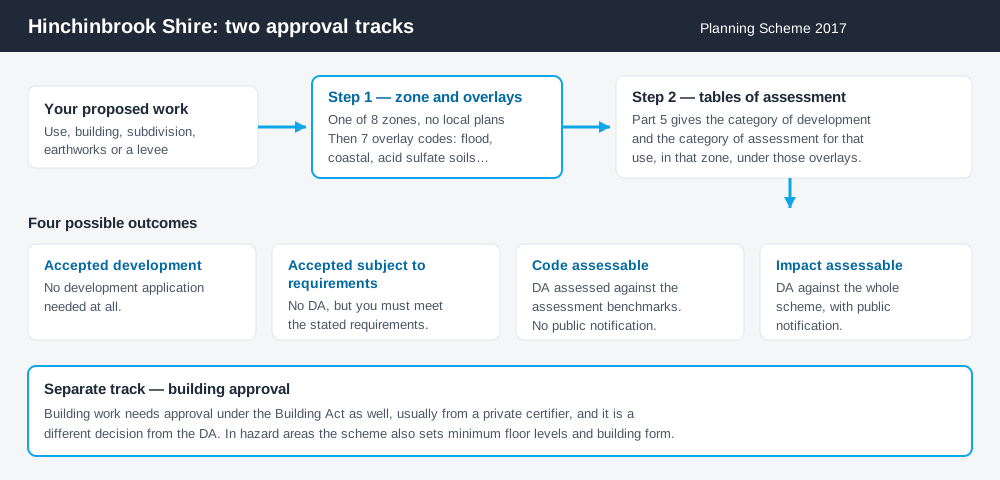
Figure 1: Two tracks run in parallel. Answering one does not answer the other.
The Hinchinbrook Shire Planning Scheme 2017
A notice was published in the Government Gazette No. 25 on 1 June 2018, and the commencement date was 2 July 2018. The scheme was drafted under the earlier planning legislation, then amended to align with the Planning Act 2016 by the Minister's rules on the same date.
There are eight zones: Rural, General residential, Mixed use, Centre, Industry, Recreation and open space, Environment management, and Community facilities. The scheme states plainly that there are no local plans — so once you know the zone and the overlays, you have the whole picture. Queensland schemes share a structure, not their content. Working out what zone your property is in is the first step.
Seven overlays, and the two that bite
Spend 5 minutes, not 3 weeks
instantDA generates a council-ready planning report for Queensland development applications. No town planner. No waiting.
Get your report →The scheme carries overlay codes for acid sulfate soils, bushfire hazard, coastal hazard, flood hazard, cultural heritage, environmental significance and extractive resources. Two drive most local outcomes.
The flood hazard overlay applies where land is mapped as low, medium or high hazard on the Schedule 2 maps. Those maps are not old. Council adopted the Herbert River Flood Study Update 2015, and it replaced the mapping in the superseded 2005 scheme. Council publishes hazard and depth maps for events from 5 year to probable maximum across Ingham, South Ingham, the Lower Herbert area, Halifax and Trebonne. Flood hazard overlays explains how the layer behaves.
The coastal hazard overlay is about storm tide, and covers different ground. Council is explicit that the beach communities — Taylors Beach, Lucinda, Forrest Beach — sit outside the river flood model and under the Hinchinbrook Storm Surge Study instead. Storm tide and coastal hazard is the relevant reading, and on cane and coastal land the acid sulfate soils overlay often applies too.
- ✓Which of the eight zones?
- ✓Flood hazard category on Schedule 2?
- ✓Storm tide, if coastal?
- ✓Acid sulfate soils?
- ✓Accepted, or assessable?
- ✓Building approval too?
Two approval tracks, not one
Development approval is a Planning Act 2016 decision. Council is the assessment manager, and it deals with land use, siting, scale and the scheme's codes.
Building approval is a Building Act decision about whether the structure complies with the building assessment provisions, and it is usually given by a private certifier. Council keeps separate guidance for building and plumbing applications, living in sheds, shipping containers and pool safety — a fair signal of what comes across the counter here. Building approval versus development approval covers the distinction.
Checking your own address
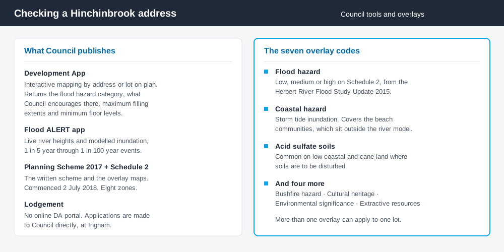
Figure 2: What Council publishes, and what each tool is actually for.
Council's Development App is unusually good for a shire this size. For an address or lot on plan it returns the flood hazard category applying to the land, the development Council encourages or would prefer not to see in that category, and requirements such as maximum filling extents or minimum floor levels. It generates a downloadable report.
Alongside it, the Flood ALERT application shows live river heights and modelled inundation for events from 1 in 5 year to 1 in 100 year. Read either with the scheme itself, not instead of it.
What catches Hinchinbrook owners out
Floor levels and building form. The scheme does not simply keep development out of hazard areas — it dictates how buildings behave in them. In storm tide inundation areas the acceptable outcomes call for open ground floors that allow water to flow through, expressly not single storey slab on ground. That is a design constraint before it is a planning one.
Cane infrastructure. In the Rural zone, acceptable outcomes set buildings back a minimum of 25 metres from cane rail infrastructure, and the scheme protects the continued operation of the shire's two sugar mills. Neighbouring an operating mill or tramline changes what will be supported. Building on rural land covers the wider rural picture.
Levees. Building or modifying a levee is assessable development. Category 1 levees have no off-property impact and are accepted development subject to the state code, with Council notified within ten business days. Category 2 needs code assessment, Category 3 impact assessment.
When you will probably need a DA
Work that starts a new use, materially increases the intensity of an existing one, reconfigures a lot, involves earthworks or filling, or sits in a mapped flood, storm tide or acid sulfate soils area is likely to be assessable. Modest work on an unconstrained lot in Ingham is more often accepted development, subject to the requirements attached.
What to do next
Run the address through the Development App, note the flood hazard category and any minimum floor level, then read the table of assessment for what you intend to do.
If you'd rather see the zone, the mapped constraints and the likely category of assessment for a Hinchinbrook address in one place, an instantDA planning report does that for $169 — against the $800–$1,500 a town planner typically charges for a preliminary opinion. You can start a report in a few minutes.
Then budget. Council's adopted 2026–2027 fees and charges set a development permit or preliminary approval for a dwelling house at $215.00, code assessment for other uses at $1,566.00, and an impact assessment material change of use at $3,133.00. Figures are re-adopted annually, so check the current schedule. Council's planning scheme page has the document, and the interactive mapping page has both apps.
Frequently asked questions
What is Hinchinbrook Shire's planning scheme?
How do I lodge a development application in Hinchinbrook?
How much does a development application cost in Hinchinbrook?
Which flood mapping does the scheme use?
Do I need approval to build a levee?
Ready to generate your report?
Skip the writing. Get a council-ready planning report in 5 minutes.
Get your report