Key takeaways
- ✓The scheme is the Longreach Region Planning Scheme 2015, Version 3, in effect from 6 May 2024.
- ✓It has twelve zones, including a Tourism zone, and only two overlay codes — airport environs and flood.
- ✓Bushfire, agricultural land and ecological significance are mapped, but as other planning scheme maps rather than overlay codes.
- ✓Standard siting is 6m from any road frontage and 1.5m from a side boundary; building closer needs an alternative siting assessment decided by Council.
- ✓There is no online lodgement portal — applications go to Council on DA Form 1.
Do You Need Council Approval in Longreach?
You'll usually hear this called a development application, or DA — that's the formal name for council approval under the Planning Act 2016. In the Longreach region, Council is the assessment manager, and the rules it applies come from the Longreach Region Planning Scheme 2015.
What makes Longreach unusual is how little the scheme maps. Where a coastal council might carry twenty overlays, Longreach carries two. That sounds relaxed until you realise the constraints have not gone anywhere — they have simply moved into other parts of the scheme, where people forget to look.
In this guide: how the scheme is built, the two approval tracks, how to check an address, and what catches owners out between Longreach, Ilfracombe and Isisford.
Get a council-ready planning report in 5 minutes — no planner, no waiting.
Get your report →The short answer
You need a development application in Longreach when the Longreach Region Planning Scheme 2015 makes your work code or impact assessable for its zone. Much minor work in town is accepted development. Building approval is separate, and Council's 6 metre and 1.5 metre setbacks catch people out.
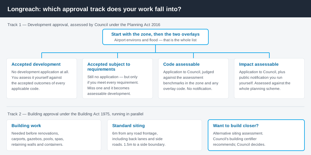
Figure 1: Two tracks run in parallel. Answering one does not answer the other.
The Longreach Region Planning Scheme 2015
Council publishes Version 3, which has had effect since 6 May 2024, replacing Version 2. The original scheme was gazetted in April 2015 and commenced that June, which is where the year in the name comes from.
Like every Queensland scheme it follows the standard structure — strategic framework, zones, overlays, codes, tables of assessment. But Queensland schemes share that structure, not their content, and Longreach's content is its own. There are twelve zones: Centre, Community facilities, Environmental management and conservation, Industry, Industry investigation, Low density residential, Medium density residential, Recreation and open space, Rural, Rural residential, Tourism and Township.
The Tourism zone is worth pausing on. The strategic framework names attractions it does not want new development to compromise — the Australian Stockman's Hall of Fame, the Qantas Museum and Outback Founders Museum, the Powerhouse Museum, and at Ilfracombe the Great Machinery Mile, Langenbaker House and the Wellshot. Isisford gets the Outer Barcoo Interpretation Centre and the Major Mitchell Monument. Tourism here is a named strategic outcome, not an afterthought. Working out your zone is always the first move.
Only two overlays — and where the rest hide
Spend 5 minutes, not 3 weeks
instantDA generates a council-ready planning report for Queensland development applications. No town planner. No waiting.
Get your report →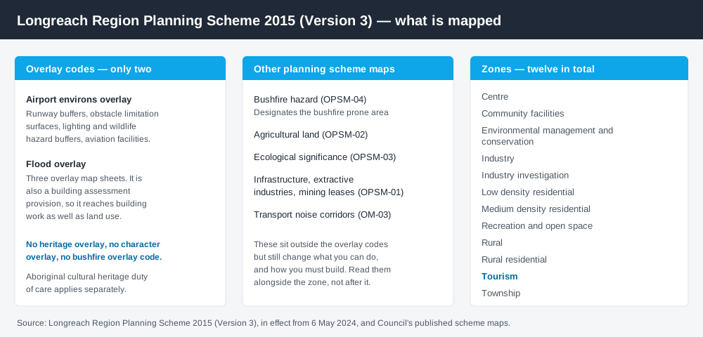
Figure 2: The overlays are short. The maps behind them are not.
The scheme has exactly two overlay codes: airport environs, and flood.
The airport environs overlay reaches further than most people expect. It covers runway buffers, obstacle limitation surfaces, aviation facilities, a lighting area buffer and a wildlife hazard buffer around Longreach Airport — and it appears in Council's own assessments of ordinary town sites.
The flood overlay is the one that shapes the region. Longreach sits on the Thomson River, Isisford on the Barcoo, and this is Channel Country: water spreads across floodplain rather than running down a gully. Council publishes three flood hazard map sheets. Critically, the flood overlay code is also a building assessment provision, so it reaches your building work, not only your land use. Flood hazard overlays explains how that layer behaves.
Everything else is mapped as an other planning scheme map: bushfire hazard, agricultural land, ecological significance, infrastructure and mining interests, plus transport noise corridors. Bushfire deserves particular note — there is no bushfire overlay code, but Council designates the bushfire prone area on its hazard map for building purposes. Read only the overlay list and you will miss it, so check the overlays properly.
Two approval tracks, not one
Development approval is a Planning Act 2016 decision, made by Council as assessment manager, about land use, siting, scale and compliance with the scheme's codes. Council lodgement is on DA Form 1 — there is no online portal here, so applications go to Council directly.
Building approval is a Building Act decision, usually given by a private certifier, about whether the structure complies. Council is clear that building approval is required before renovations, alterations or additions, and for carports, outdoor areas, gazebos, pools and pool fences, spas, retaining walls and shipping containers. Where a private certifier lodges on your behalf, Council still requires payment of its fees including an archival fee and building refuse charge. Building approval versus development approval sets out the split.
What catches Longreach owners out
Setbacks. This is the single most common trip. Council's standard is 6 metres from any road frontage — including back lanes and side roads — and 1.5 metres from any side boundary. On a Longreach corner block with a rear lane, that is three separate 6 metre frontages, and it rules out a great many shed and carport positions. To build closer you need an alternative siting assessment, which Council's building certifier assesses and recommends, with the decision then made at a Council meeting. That is a real timeline, not a counter transaction. Siting variations covers the process.
Short-term accommodation. Tourism drives the local economy, and letting a house or cottage to visitors is a material change of use, not a private arrangement. Council has assessed short-term accommodation in the Medium density residential zone as code assessable — an application, assessed against benchmarks, with a decision. Short-stay accommodation rules explains the pattern.
Rural scale. Grazing dominates the region, and large holdings invite the assumption that nothing is regulated. Reconfiguring a lot, operational works such as earthworks or clearing, and new uses on rural land all engage the scheme.
- ✓Which of the twelve zones?
- ✓Airport environs overlay?
- ✓Flood overlay?
- ✓Bushfire prone on the hazard map?
- ✓6m and 1.5m setbacks met?
- ✓Building approval too?
When you will probably need a DA
Work that starts a new use, materially increases the intensity of an existing one, subdivides or realigns boundaries, alters the shape of the land, sits in the flood overlay, or falls inside the airport environs overlay is likely to be assessable. Modest work in town on an unconstrained lot, meeting the setbacks, is far more often accepted development.
What to do next
Get the zone from the scheme's zone maps, then check the same address against the flood and airport environs overlay maps and the bushfire hazard map. Cross-check state layers on the Queensland Globe.
If you'd rather see the zone, the mapped constraints and the likely category of assessment for a Longreach address in one place, an instantDA planning report does that for $169 — against the $800–$1,500 a town planner typically charges for a preliminary opinion. You can start a report in a few minutes.
Then talk to Council. It offers a pre-lodgement service, and in a region this size a conversation before you draw anything saves more than it costs. Council's planning scheme page has the current scheme and every map sheet.
Frequently asked questions
What is Longreach's planning scheme?
How many overlays does the Longreach scheme have?
What are the building setbacks in Longreach?
How much does a development application cost in Longreach?
Can I lodge a development application online in Longreach?
Ready to generate your report?
Skip the writing. Get a council-ready planning report in 5 minutes.
Get your report