Key takeaways
- ✓Mackay's planning scheme is the Mackay Region Planning Scheme 2017, currently version 5.0, which commenced on 15 June 2026.
- ✓MiMAPS is Council's mapping system, and its planning scheme report pulls your zone, local plan and overlays together for an address.
- ✓The Flood and coastal hazard overlay is the constraint that bites hardest across the Pioneer River floodplain and the Northern Beaches.
- ✓Development approval and building approval are separate. A private certifier usually handles the building side.
- ✓Council also publishes a Property Flood Report tool, which is worth running before you design anything.
Do You Need Council Approval in Mackay?
You'll usually hear this called a development application, or DA — that's the formal name for council approval under the Planning Act 2016. In the Mackay region, Mackay Regional Council is the assessment manager for most of them, and the rules it applies come from the Mackay Region Planning Scheme 2017.
Mackay is an unusually mixed area to plan in. A city sits at the mouth of the Pioneer River, low-lying beach suburbs run north of it, cane country wraps the urban edge, and the Pioneer Valley climbs west toward Eungella. A rule that feels obvious in one setting is often wrong in another.
Get a council-ready planning report in 5 minutes — no planner, no waiting.
Get your report →The short answer
In Mackay you need a development application when the Mackay Region Planning Scheme 2017 makes the work assessable for your zone, local plan and overlays. Much minor domestic work is accepted development. Building approval is a separate matter, usually decided by a private certifier rather than Council.
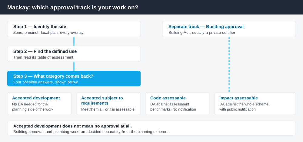
Figure 1: Two tracks run side by side. Clearing one does not clear the other.
The Mackay Region Planning Scheme 2017
Council adopted version 5.0 on 1 June 2026 and it commenced on 15 June 2026, replacing the versions running since the scheme first took effect in July 2017. Like every Queensland scheme it follows the standard state structure — strategic framework, zones, overlays, tables of assessment — but the codes layered on top are Mackay's own. Queensland schemes are not uniform, so nothing you read about another council transfers cleanly here.
Two local plan areas add a finer grain over the zones: Mackay city centre and Marian central. Some zones are further split into precincts, labelled on the zone map with a code such as MD2. Checking the zone without checking for a precinct or local plan is a common and expensive omission. How to find out what zone your property is in covers that structure.
The scheme does not apply everywhere. The Mackay Waterfront priority development area is regulated under the Economic Development Act 2012, and in the Mackay State Development Area the Coordinator-General is the assessment manager for a material change of use.
Two approval tracks, not one
Spend 5 minutes, not 3 weeks
instantDA generates a council-ready planning report for Queensland development applications. No town planner. No waiting.
Get your report →This distinction saves Mackay homeowners more money than anything else on this page.
Development approval is a Planning Act 2016 decision. Council is the assessment manager. It deals with land use, siting, scale and compliance with the scheme's codes.
Building approval is a Building Act decision about whether the structure complies with the building assessment provisions, usually given by a private certifier, not Council.
Separate approvals, separate legislation, separate decision-makers. A patio can be accepted development under the scheme and still need building approval. Holding a building approval does not cure the absence of a development approval. Building approval versus development approval sets out the distinction in full.
- ✓What zone and precinct applies?
- ✓Is the site in a local plan area?
- ✓Which overlays touch it?
- ✓Accepted, or assessable?
- ✓Do you also need building approval?
Checking your own address
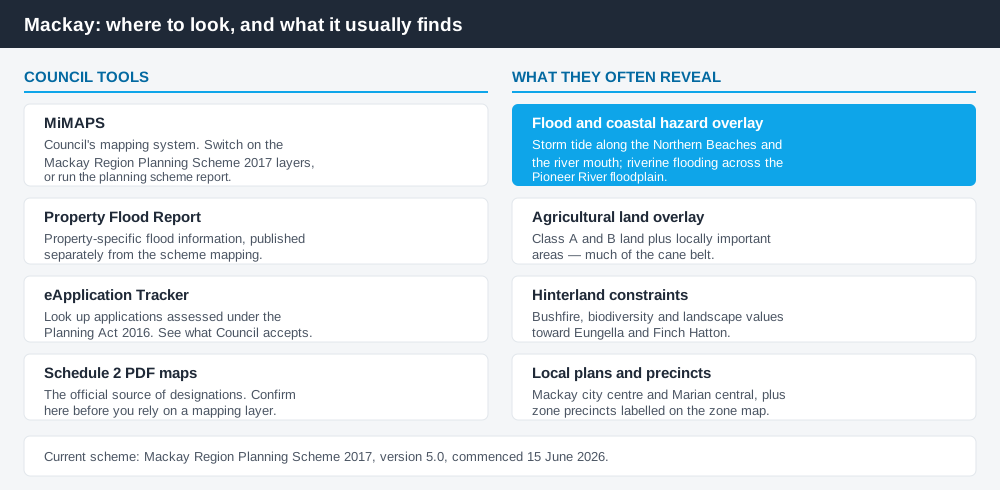
Figure 2: Council's own tools, and the constraints they most often reveal.
Council's mapping system is MiMAPS, at mimaps.mackay.qld.gov.au. Expand the Mackay Region Planning Scheme 2017 box to switch on the designation layers. The fastest route is the planning scheme report in the analysis tab, which returns the zone, any local plan and every overlay in one document. Council notes the official source of designations remains the Schedule 2 PDF maps, so use MiMAPS to orient yourself and the maps to confirm.
Council also publishes a separate Property Flood Report tool and an eApplication tracker for applications assessed under the Planning Act 2016. What has been approved nearby is often more informative than the code text. For state layers such as vegetation, cross-check the Queensland Globe; how to check overlays walks through it.
What catches Mackay owners out
Flood and coastal hazard. This overlay does the most work in Mackay. It picks up storm tide inundation along the Northern Beaches and around the river mouth, and riverine flooding across the Pioneer River floodplain, driving floor levels, siting and sometimes the category of assessment. Council has amended its flood hazard mapping since the scheme commenced, so a position checked years ago may have moved. Read flood hazard overlays and storm tide and coastal hazard before committing to a design.
Agricultural land. The agricultural land overlay covers land mapped as class A and B plus locally important agricultural areas — in Mackay, much of the cane belt around the urban fringe. Non-agricultural uses there attract real scrutiny. Building on rural land explains why.
Hinterland sites. Toward Eungella and Finch Hatton, bushfire, biodiversity and landscape values combine on the same lot and services are limited. Council has run a dedicated Finch Hatton and Eungella amendment, so confirm the current position.
Workforce accommodation. Mackay services the Bowen Basin, and accommodation for a non-resident workforce is its own defined use with its own level of assessment. Do not assume it reads across from residential or tourist uses.
When you will probably need a DA
Work that changes the use of a property, adds a dwelling, subdivides, sits on mapped agricultural land, or falls inside the flood and coastal hazard overlay is likely to be assessable. Minor domestic work on an unconstrained suburban lot — a modest shed, a standard fence, internal alterations that do not change floor area, height or structure — is much more often accepted development, subject to any requirements attached. The only reliable answer comes from the table of assessment for your defined use, read against your zone, local plan and overlays.
What to do next
Run the planning scheme report for your address in MiMAPS, run the property flood report alongside it, then read the table of assessment for what you intend to build.
If you'd rather see the zone, the overlays and the likely category of assessment for a Mackay address pulled together in one place, an instantDA planning report does that for $169 — against the $800–$1,500 a town planner typically charges for a preliminary opinion. You can start a report in a few minutes.
Then confirm with Council. Mackay Regional Council takes planning enquiries and pre-lodgement requests through its online forms, and for anything touching flood, coastal hazard or agricultural land that conversation is worth having before you engage a designer. Fees are set annually in the Schedule of Fees and Charges — in the 2026-27 schedule a mini material change of use carries an adopted fee of $850. Check the current schedule, because these figures change each financial year.
Frequently asked questions
What is Mackay's planning scheme?
How do I check the zoning of a Mackay property?
Which overlay matters most in Mackay?
Is building approval the same as council approval in Mackay?
How much does a development application cost in Mackay?
Ready to generate your report?
Skip the writing. Get a council-ready planning report in 5 minutes.
Get your report