Key takeaways
- ✓The scheme is the Maranoa Planning Scheme 2017, published by Council at Version 5.
- ✓Ten zones and eight overlay codes, with separate local plan codes for Injune, Mitchell, Roma, Surat, Wallumbilla and Yuleba.
- ✓Nine towns have their own flood hazard overlay map, and Roma has three.
- ✓The Agricultural land overlay caps non-farm buildings and hardstand on Class A and Class B land at 1,000 square metres.
- ✓There is no online lodgement portal — applications go to Council by email, post or over the counter.
Do You Need Council Approval in Maranoa Regional Council?
You'll usually hear this called a development application, or DA — that's the formal name for council approval under the Planning Act 2016. In the Maranoa, Council is the assessment manager, and the rules it applies come from the Maranoa Planning Scheme 2017, which Council currently publishes as Version 5.
One scheme covers a very large slice of south west Queensland. Roma, Mitchell, Injune, Surat, Wallumbilla, Yuleba, Amby, Jackson, Muckadilla and Mungallala each have their own zone map, and six of those towns have a local plan code as well. Cattle, gas and flood are the forces shaping land use here — Council itself runs the Roma Saleyards, the Roma Quarry and the region's airports.
In this guide: how the scheme works, the two approval tracks, how to check an address, and what catches owners out.
Get a council-ready planning report in 5 minutes — no planner, no waiting.
Get your report →The short answer
You need a development application in Maranoa when the scheme's tables of assessment make your proposal code or impact assessable for its zone and overlays. Much minor work in town is accepted development. Building approval is separate, and Maranoa still takes lodgements by email, post or counter — there is no online lodgement portal.
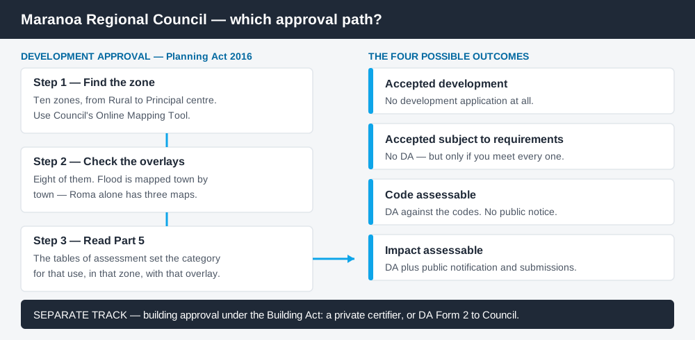
Figure 1: Two tracks run in parallel. Answering one does not answer the other.
The Maranoa Planning Scheme 2017
The scheme follows the standardised Queensland structure — strategic framework, zones, tables of assessment, overlays, development codes — but Queensland schemes share that structure, not their content. What sits inside the codes is local.
There are ten zones: Rural, Rural residential, General residential, Township, Principal centre, Major centre, District centre, Industry, Community facilities, and Recreation and open space. The centres sit in a three-tier hierarchy, and the Principal centre zone code says in terms that it applies "for all the Principal centre zone (Roma)".
Layered over that are eight overlay codes: Agricultural land, Extractive resources, Biodiversity areas, Heritage, Flood hazard, Bushfire hazard, Infrastructure, and Airport environs. Then six local plan codes for Injune, Mitchell, Roma, Surat, Wallumbilla and Yuleba, plus three precinct codes — Central living, Roma Airport, and the Wallumbilla South gas hub. Working out what zone your property is in is always the first move.
Two approval tracks, not one
Spend 5 minutes, not 3 weeks
instantDA generates a council-ready planning report for Queensland development applications. No town planner. No waiting.
Get your report →Development approval is the Planning Act 2016 decision. Council is the assessment manager, dealing with land use, siting, scale and compliance with the scheme's codes. The application is made on DA Form 1 with landowner's consent, proposal plans, and a written report addressing the relevant code criteria.
Building approval is a Building Act decision about the structure itself, usually given by a private certifier, though Council also accepts building applications on DA Form 2. Work can be accepted development under the scheme and still need building approval. Building approval versus development approval covers the split.
Council encourages a pre-lodgement meeting before you commit, arranged through its Planning team. Where one site can pick up flood mapping, agricultural land mapping and a state road frontage at once, that meeting is worth taking — pre-lodgement meetings explains what to bring.
- ✓Which of the ten zones?
- ✓Which of the eight overlays?
- ✓Flood hazard map for your town?
- ✓Accepted, or assessable?
- ✓Building approval as well?
- ✓Pre-lodgement meeting booked?
Checking your own address
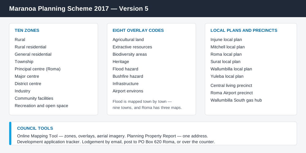
Figure 2: What the Maranoa scheme contains, and where Council publishes each piece.
Council runs an Online Mapping Tool at mapservices.maranoa.qld.gov.au, a joint initiative with the Queensland Government, showing property information, zones, overlays, infrastructure and aerial imagery. Council also offers a Planning Property Report for a specific address, and a development application tracker for applications already in the system.
The scheme is published part by part as PDFs, which matters here: the flood hazard maps are separate downloads, one per town. For state layers, cross-check the site on the Queensland Globe.
What catches Maranoa owners out
Flood. This is the big one. Nine towns have their own flood hazard overlay map, and Roma alone has three. The Flood hazard overlay code sorts land into Significant, High and Extreme flood hazard areas and Low flood hazard areas, and in the higher categories development "does not include further subdivision" and is limited to a short list — floodproofed recreation, cropping and animal husbandry, floodproofed local utilities, conservation, and replacement of existing lawful development with habitable rooms above the defined flood level. In urban areas, net filling above 50 cubic metres stops being an acceptable outcome. Flood hazard overlays explains how these layers behave.
The Agricultural land overlay. It applies to land mapped Agricultural Land Classification Class A or Class B in the state mapping, and it carries a hard number: across any site, buildings and structures not used for the primary agricultural purpose, plus parking and manoeuvring areas, plus on-site wastewater treatment and irrigation areas, must not exceed 1,000 square metres in total. Building on rural land covers the wider picture.
Gas country rules. The Wallumbilla South gas hub precinct code protects the precinct core for gas transmission infrastructure and resists encroachment by sensitive land uses including accommodation activities. The Principal centre zone code, meanwhile, states that non-resident workforce accommodation is not supported in the Roma CBD. Workers' accommodation is a land use question here.
Small structures in the Roma centre. The Principal centre zone code allows a maximum of one shipping container for storage ancillary to the main use, not exceeding 3 metres high or 12 metres long, screened, not used for habitation, and not within 250 metres of a heritage or character building. Shipping containers are a live issue across the region.
Roma airport environs. Obstacle limitation surfaces, a light restriction zone and a wildlife hazard buffer are separately mapped around Roma Airport, so height and lighting get looked at.
When you will probably need a DA
Work that starts a new use, materially increases the intensity of an existing one, subdivides or realigns boundaries, moves earth, or sits inside a mapped flood hazard area is likely to be assessable. Short-term and workforce accommodation, extractive industry and rural intensification are the recurring categories out here. Modest work in town on an unconstrained lot is far more often accepted development, subject to the requirements attached to it.
What to do next
Get the zone from Council's Online Mapping Tool, check the flood hazard map for your town, then read the Part 5 tables of assessment for what you intend to do.
If you'd rather see the zone, the mapped constraints and the likely category of assessment for a Maranoa address in one place, an instantDA planning report does that for $169 — against the $800–$1,500 a town planner typically charges for a preliminary opinion. You can start a report in a few minutes.
Then talk to Council. Applications go to the Planning team by email, by post to PO Box 620 Roma, or over the counter at any Maranoa office, and fees are set in Council's schedule, reviewed annually. Council's Town Planning page links the scheme, its parts and the fee schedule.
Frequently asked questions
What is Maranoa Regional Council's planning scheme?
Does Maranoa have online planning maps?
How do I lodge a development application with Maranoa Regional Council?
How much does a development application cost in the Maranoa?
Which overlays are in the Maranoa Planning Scheme?
Ready to generate your report?
Skip the writing. Get a council-ready planning report in 5 minutes.
Get your report