Key takeaways
- ✓The scheme is the City of Mount Isa Planning Scheme, which commenced on 9 March 2020.
- ✓The local government area is about 43,310 square kilometres — the scheme calls Mount Isa geographically the second largest city in Australia.
- ✓There are ten overlay codes, and none of them is an air quality overlay. Emissions are handled through zoning geography and code performance outcomes instead.
- ✓Council uses IsaMaps for public mapping. There is no online lodgement portal — forms go to Council directly.
- ✓Council's Register of Cost Recovery Fees 2026/2027 lists a home-based business material change of use at $679.25.
Do You Need Council Approval in Mount Isa?
You'll usually hear this called a development application, or DA — that's the formal name for council approval under the Planning Act 2016. In Mount Isa, Council is the assessment manager, and the rules it applies come from the City of Mount Isa Planning Scheme, which commenced on 9 March 2020.
Mount Isa is unlike anywhere else in Queensland to plan in. The scheme's strategic intent puts the local government area at approximately 43,310 square kilometres, which it describes as making Mount Isa geographically the second largest city in Australia. Inside it sit one dense mining city, the township of Camooweal 200 kilometres north west, and a heavy industrial complex embedded in the town rather than on its edge.
Get a council-ready planning report in 5 minutes — no planner, no waiting.
Get your report →The short answer
In Mount Isa you need a development application when the City of Mount Isa Planning Scheme makes your work assessable for its zone and overlays. Plenty of ordinary house work is accepted development. Building approval is separate and usually comes from a private certifier. Council has no online lodgement portal.
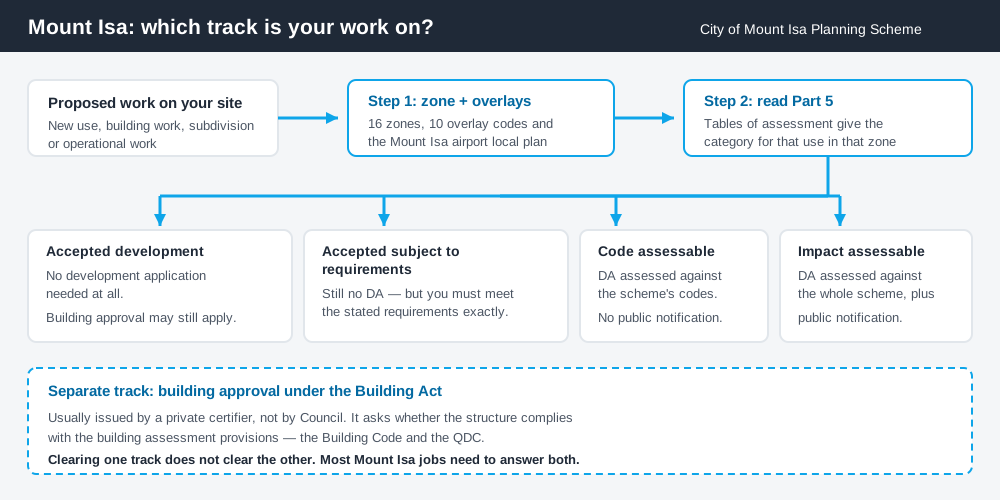
Figure 1: Two tracks run in parallel. Clearing one does not clear the other.
The City of Mount Isa Planning Scheme
The scheme follows the structure used across Queensland — strategic framework, tables of assessment, zones, local plans, overlays, development codes — but the content is Mount Isa's own. Queensland schemes share a structure, not a rulebook, so never assume a Brisbane answer transfers here.
Sixteen zone codes cover the city, including three industrial tiers — Low impact industry, Medium impact industry and Special industry — in a city of roughly 23,000 people, which tells you what drives the place. Reading your zone is the first step: what zone is my property in covers how, and industry zones explains what those tiers permit. There is also one local plan, the Mount Isa airport local plan.
Emissions, buffers and where they actually live in the scheme
Spend 5 minutes, not 3 weeks
instantDA generates a council-ready planning report for Queensland development applications. No town planner. No waiting.
Get your report →This is the part most people get wrong. Mount Isa's stacks are famous, and it is natural to assume the scheme carries an air quality overlay you can look up. It does not. There are ten overlay codes and none is an air quality or buffer overlay.
Separation sits somewhere less obvious — the strategic framework, and performance outcomes inside the codes. The framework states plainly that residential development is to avoid land subject to contamination including lead contamination, and records that newer residential areas such as Healy Heights and the 'Gliderport' land sit south east of the main stacks and generally upwind. It makes the Low impact industry zone a buffer between residential zones and Medium impact industry, and places the Special industry zone south of the city, at least two kilometres from existing or future residential areas.
It bites at assessment too. The reconfiguring a lot code requires that reconfiguration not result in lots intended for residential activities or sensitive land uses being subject to adverse air quality or impacts — with no acceptable outcome prescribed, so it has to be argued on merit.
Glencore's underground copper mines at Mount Isa closed in July 2025 and the copper smelter has continued operating. Either way, the scheme's separation logic is what your application is assessed against.
Two approval tracks, not one
Development approval is a Planning Act 2016 decision made by Council as assessment manager. It deals with land use, siting, intensity and compliance with the scheme's codes.
Building approval is a Building Act decision about whether the structure complies with the building assessment provisions, usually issued by a private certifier. The scheme's Part 1 confirms it regulates building work only to the extent the Building Act permits — chiefly QDC siting matters such as boundary clearances and site cover for Class 1 and 10 structures. Building approval versus development approval sets out the split.
- ✓Which of the sixteen zones?
- ✓Any of the ten overlays?
- ✓Inside the airport local plan?
- ✓Accepted, or assessable?
- ✓Building approval too?
- ✓Fee from the current cost recovery register?
Checking your own address
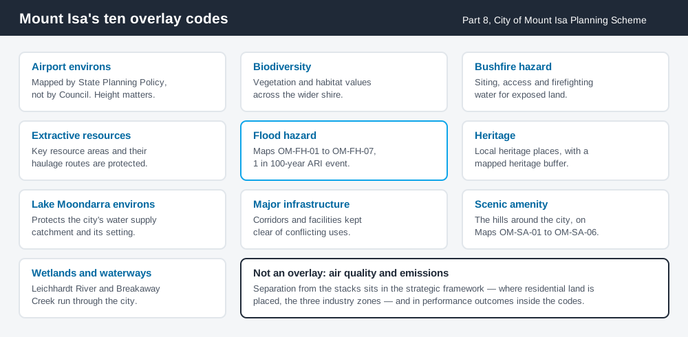
Figure 2: The ten overlays — and the constraint that is not one of them.
Council runs public mapping through IsaMaps, an ArcGIS hub reached from its Infrastructure Services page, with a Public Explorer for residents. Start there for zoning, then open the scheme. Schedule 2 Mapping is a separate download, holding the flood layer as Maps OM-FH-01 to OM-FH-07.
Not every overlay is council-drawn: the Airport environs overlay points to State Planning Policy interactive mapping for obstacle limitation surfaces, so a tall structure can be constrained by a state layer instead. Cross-check on the Queensland Globe, and read how to check overlays before assuming a clear site.
What catches Mount Isa owners out
Flood. The Flood hazard overlay maps a 1 in 100-year Annual Recurrence Interval event. The Leichhardt River and Breakaway Creek run through the urban area and the scheme names them the primary waterway corridors. In a dry landscape it is easy to forget the river is a river. Flood hazard overlays explains how mapping changes your category of assessment.
Assuming rural means unregulated. Almost all of that 43,310 square kilometres is Rural zone, and reconfiguring a lot, operational work, earthworks and extractive industry all engage the scheme however remote the site.
Working from home. Mount Isa has a dedicated home based business code, and the fee register prices that material change of use separately. Home business approval covers when it needs a DA.
When you will probably need a DA
Work that starts a new use or materially intensifies an existing one, subdivides or realigns boundaries, involves significant earthworks, sits in a mapped overlay, or introduces a sensitive use near industrial land is likely to be assessable. Straightforward house work on an unconstrained residential lot is far more often accepted development, subject to any requirements attached.
What to do next
Get your zone from IsaMaps, check Schedule 2 mapping and the overlay maps for the same address, then read Part 5 for what you intend to do.
If you'd rather see the zone, the mapped constraints and the likely category of assessment for a Mount Isa address in one place, an instantDA planning report does that for $169 — against the $800–$1,500 a town planner typically charges for a preliminary opinion. You can start a report in a few minutes.
Then talk to Council. There is no online lodgement portal here: forms come from Council's development pages and go to the planning team by email or to 23 West Street. Confirm your fee against the current register first.
Frequently asked questions
What is Mount Isa's planning scheme?
Does Mount Isa have an online DA portal?
How much does a development application cost in Mount Isa?
Is there an air quality overlay in Mount Isa?
Which overlays apply in Mount Isa?
Ready to generate your report?
Skip the writing. Get a council-ready planning report in 5 minutes.
Get your report