Key takeaways
- ✓Murweh runs the Murweh Shire Planning Scheme, gazetted 17 November 2017 and commenced 1 December 2017.
- ✓There are four zones — Township, Rural, Rural residential, and Recreation and open space — with Commercial, Industrial and Residential precincts inside the Township zone.
- ✓The scheme has no overlay codes. Flood comes from Schedule 2 mapping; bushfire from state mapping.
- ✓Charleville and Augathella both sit behind flood protection levees, and the scheme treats the leveed areas as the sensible place to build.
- ✓There is no online lodgement portal — a development application goes to Council by email, post or over the counter in Alfred Street.
Do You Need Council Approval in Murweh Shire?
You'll usually hear this called a development application, or DA — that's the formal name for council approval under the Planning Act 2016. In Murweh, Council is the assessment manager, and the rules it applies come from the Murweh Shire Planning Scheme.
Murweh is mulga country in south west Queensland. Charleville is the main town, Augathella second, Morven the smallest. The economy the scheme describes is grazing, an abattoir, health services including the Royal Flying Doctor Service, and tourism built on the Cosmos Centre Observatory and the Bilby Experience.
Get a council-ready planning report in 5 minutes — no planner, no waiting.
Get your report →The short answer
In Murweh Shire you need a development application when the Murweh Shire Planning Scheme makes your work assessable in your zone. The scheme has four zones and no overlay codes. Flood is assessed only where Schedule 2 mapping shows it. Building approval is separate, and there is no online portal.
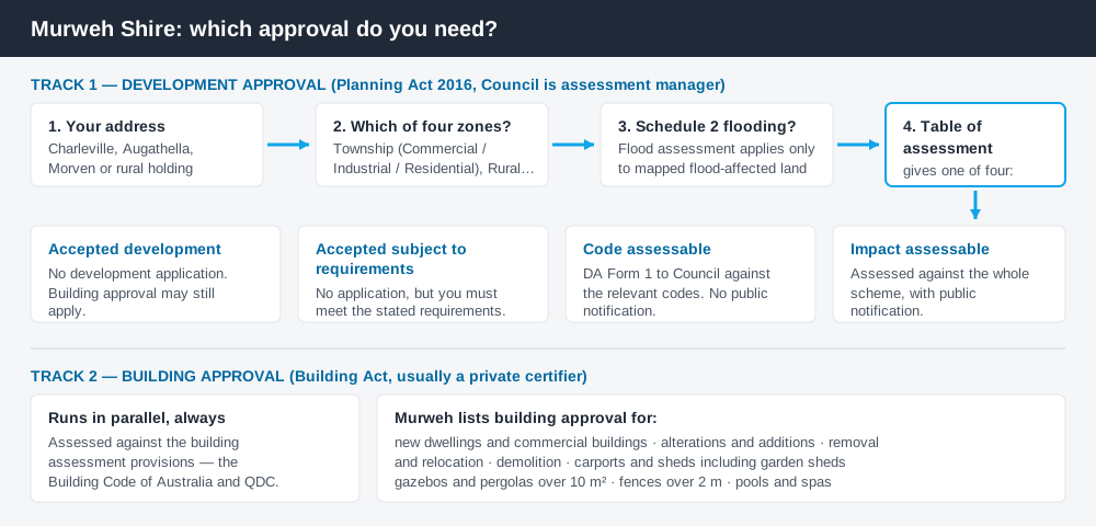
Figure 1: Two tracks run in parallel. Clearing one does not clear the other.
The Murweh Shire Planning Scheme
The scheme may be cited simply as the Murweh Shire Planning Scheme. A notice was published in Government Gazette No. GAZ46 on 17 November 2017, and the commencement date was 1 December 2017. It was prepared under the Sustainable Planning Act 2009 and later amended for alignment with the Planning Act 2016, so its vocabulary is current though the drafting is older. Amendments sit in Appendix 2.
It follows the standardised Queensland structure — strategic framework, tables of assessment, zones, codes, schedules — but Queensland schemes share that structure, not their content. Murweh's is genuinely small. There are four zones: Recreation and Open Space, Rural, Rural Residential, and Township. The Township zone carries three precincts — Commercial, Industrial and Residential — which is how Charleville's separated town centre, housing and industrial areas are handled. Almost everything outside the three towns is Rural, and the codes are few: General development, Non-resident workforce accommodation, Operational works and Reconfiguring a lot. Which zone applies is the first step here.
No overlay codes — Schedule 2 carries the constraints
Spend 5 minutes, not 3 weeks
instantDA generates a council-ready planning report for Queensland development applications. No town planner. No waiting.
Get your report →Murweh's scheme has no overlay codes at all. Where a city scheme sends you to a flood or heritage overlay, Murweh's tables of assessment point straight at mapping.
Flood runs through Schedule 2 – Mapping, which has flood hazard sheets for the shire, for Charleville and for Augathella, plus a combined Charleville zone-and-flooding sheet. The scheme is explicit that flood assessment applies only to sites affected by flooding and shown on Schedule 2. Bushfire is different again — the scheme sends you to state natural hazard mapping, not a council layer. Flood hazard mapping and bushfire hazard mapping explain how these layers behave.
Schedule 2 also holds three sheets most schemes lack: Charleville obstacle limitation surfaces tied to the airport, Natural Sciences Loop tourism mapping, and an Abandoned Mines Map.
Two approval tracks, not one
Development approval is a Planning Act 2016 decision made by Council as assessment manager, dealing with land use, siting, scale and the scheme's assessment benchmarks.
Building approval is a separate decision under the Building Act, assessed against the building assessment provisions including the QDC, and usually given by a private certifier. Council's guidance lists what needs it: new dwellings, alterations and additions, demolition, carports and sheds, gazebos and pergolas over 10 square metres, fences over 2 metres, and pools. Building approval versus development approval covers the split.
- ✓Which of the four zones?
- ✓Which Township precinct?
- ✓On Schedule 2 flood mapping?
- ✓Accepted, or assessable?
- ✓Building approval too?
- ✓Current fee from Council?
Checking your own address
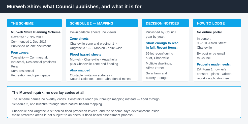
Figure 2: What Murweh publishes, and what each source is for.
Murweh runs no ePlan platform or online mapping viewer. Council publishes the complete scheme as a single document, and Schedule 2 as individual map sheets you download one at a time — zone and precinct sheets for Charleville, zone sheets for Augathella, Morven and the shire, and flood hazard sheets. You match your address by eye, so a call to Council is worth more here than in a city.
Council also publishes decision notices, a register short enough to read in full and a good guide to what Council actually approves: a 65-lot reconfiguring a lot off Racecourse Road, multiple dwellings in Alfred Street, a car wash in Galatea Street, a solar farm with battery storage. Cross-check state layers on the Queensland Globe.
What catches Murweh owners out
Flood, and the levee. Charleville has taken the brunt of the Warrego River repeatedly — the April 1990 flood remains the record event, and 2008 flooded homes and businesses again. Charleville and Augathella now sit behind flood protection levees, which the scheme states were built to give residents flood immunity to a 1 in 200 year level. The planning consequence is the part people miss: development inside those protected areas is not subject to an onerous flood-based assessment, while a site outside them, or on Schedule 2, is a different proposition.
Heritage. Charleville's main street is a genuine heritage streetscape — wide streets on a grid, the Railway Station, the Corones Hotel, the School of Arts building. Some places are state heritage listed, others are local heritage places in Schedule 6. The scheme supports adaptation and re-use, but expects changes to protect fabric and setting. Heritage constraints explain that.
Rural scale. Holdings are large and almost all Rural zoned. "Rural means unregulated" is a costly mistake — reconfiguring a lot, operational work such as earthworks or clearing, and non-resident workforce accommodation all engage the scheme, and the stock route network and the Charleville abattoir are protected from encroachment by sensitive uses. Building on rural land covers it.
When you will probably need a DA
Work that starts a new use, increases the intensity of an existing one, subdivides or realigns boundaries, moves earth, or sits on mapped flood land is likely to be assessable. Short-term accommodation that value-adds to the Cosmos Centre and the Bilby Experience is encouraged by the strategic framework, but is still a material change of use. Modest work on an unconstrained Township lot is more often accepted development.
What to do next
Get the zone from the relevant Schedule 2 sheet, check the flood hazard sheet for that address, then read the table of assessment.
If you would rather see the zone, the mapped constraints and the likely category of assessment for a Murweh address in one place, an instantDA planning report does that for $169 — against the $800–$1,500 a town planner charges for a preliminary opinion. You can start a report in minutes.
Then contact Council. A properly made application needs DA Form 1, the landowner's consent, proposal plans and a written report addressing the relevant code criteria, plus the fee — and with no portal, it goes by email, by post, or over the counter at 95–101 Alfred Street, Charleville. Council's Development Applications page has the lodgement details and decision notices.
Frequently asked questions
What is Murweh Shire's planning scheme?
How do I lodge a development application in Murweh Shire?
How much does a development application cost in Murweh Shire?
Are there overlays in the Murweh planning scheme?
Ready to generate your report?
Skip the writing. Get a council-ready planning report in 5 minutes.
Get your report