Key takeaways
- ✓The scheme is the North Burnett Regional Planning Scheme, gazetted 24 October 2014 and commenced 3 November 2014. Council publishes Revision 1.4.
- ✓There are eight zones and only four overlay codes — bushfire hazard, flood hazard, infrastructure, and natural features or resources.
- ✓The scheme states there are no local plans. Each of the six towns is zoned on its own map sheet instead.
- ✓Flood hazard carries fifteen overlay map sheets, more than any other layer — the Burnett River is the dominant constraint.
- ✓There is no online lodgement portal. Applications go to a Council office, by email, or by post to Gayndah.
Do You Need Council Approval in North Burnett?
You'll usually hear this called a development application, or DA — that's the formal name for council approval under the Planning Act 2016. In North Burnett, Council is the assessment manager, and the rules it applies come from the North Burnett Regional Planning Scheme.
North Burnett is unusual in having no dominant centre. Six towns — Gayndah, Mundubbera, Biggenden, Eidsvold, Monto and Mount Perry — share the region, and the scheme maps each separately rather than treating any as a regional capital. Gayndah and Mundubbera anchor the Central Burnett citrus districts, on river flats that are also the most flood-exposed land here.
In this guide: how the scheme works, the two approval tracks, how to check an address, and what catches owners out.
Get a council-ready planning report in 5 minutes — no planner, no waiting.
Get your report →The short answer
In North Burnett you need a development application when the North Burnett Regional Planning Scheme makes your work assessable in your zone. Flood mapping along the Burnett River is the most common trigger. Building approval is separate, and there is no online lodgement portal — applications go to Council directly.
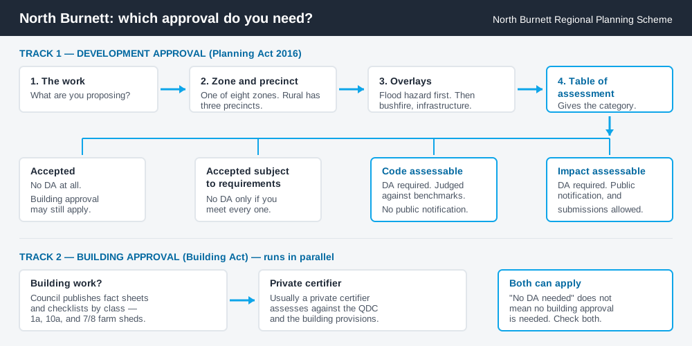
Figure 1: Two tracks run in parallel. Answering one does not answer the other.
The North Burnett Regional Planning Scheme
The scheme says of itself that it "may be cited as the North Burnett Regional Planning Scheme". A notice was published in Government Gazette No. 42 on 24 October 2014, and it commenced on 3 November 2014. The version Council publishes is Revision 1.4.
It follows the standardised Queensland structure — strategic framework, tables of assessment, zones, overlays, codes — but the content is local, and Queensland schemes share that structure rather than sharing rules. There are eight zones: Centre, Community facilities, General residential, Industry, Recreation and open space, Rural residential, Rural, and Township.
The Rural zone splits into three precincts — Conservation, Hinterland and Intensive agriculture — and which one you are in changes what the Rural zone code asks. Intensive agriculture is the citrus country, and its performance outcomes turn on whether a use would restrict cropping on neighbouring land.
One line matters more than it looks: the scheme records that there are no local plans. Nothing sits between the zone and your site. Working out what zone your property is in is therefore most of the answer here.
Four overlays, and flood dominates
Spend 5 minutes, not 3 weeks
instantDA generates a council-ready planning report for Queensland development applications. No town planner. No waiting.
Get your report →The scheme has just four overlay codes: bushfire hazard, flood hazard, infrastructure, and natural features or resources — the last being where extractive resources are picked up.
The weighting shows in the mapping. Council publishes fifteen flood hazard overlay map sheets, against eight each for extractive resources and infrastructure. No other constraint here is mapped in that much detail, and there is a reason. In the January 2013 event, Council's own flood mitigation study records 72 houses and 11 businesses inundated at Mundubbera and 73 houses and 28 businesses at Gayndah, with extensive damage to citrus orchards and other crops along the river. Flood hazard overlays and bushfire hazard overlays explain how these layers change your category of assessment.
Two approval tracks, not one
Development approval is a Planning Act 2016 decision. Council is the assessment manager, dealing with land use, siting, scale and compliance with the scheme's codes.
Building approval is a Building Act decision about whether the structure complies with the building assessment provisions, usually given by a private certifier. Council publishes fact sheets and checklists by building class — Class 1a dwellings, Class 10a sheds and carports, Class 7/8 farm sheds. Building approval versus development approval covers the distinction.
Council's adopted 2026–27 Fees and Charges schedule prices these separately. A code assessable material change of use for accommodation activities — caretaker's accommodation, dwelling house, dwelling unit or dual occupancy — is listed at $2,585.00 including GST. Fees reset each financial year, so confirm the current figure before you budget.
- ✓Which of the eight zones?
- ✓Rural precinct — conservation, hinterland or intensive agriculture?
- ✓On the flood hazard overlay?
- ✓Accepted, or assessable?
- ✓Building approval too?
- ✓Current year's fee?
Checking your own address
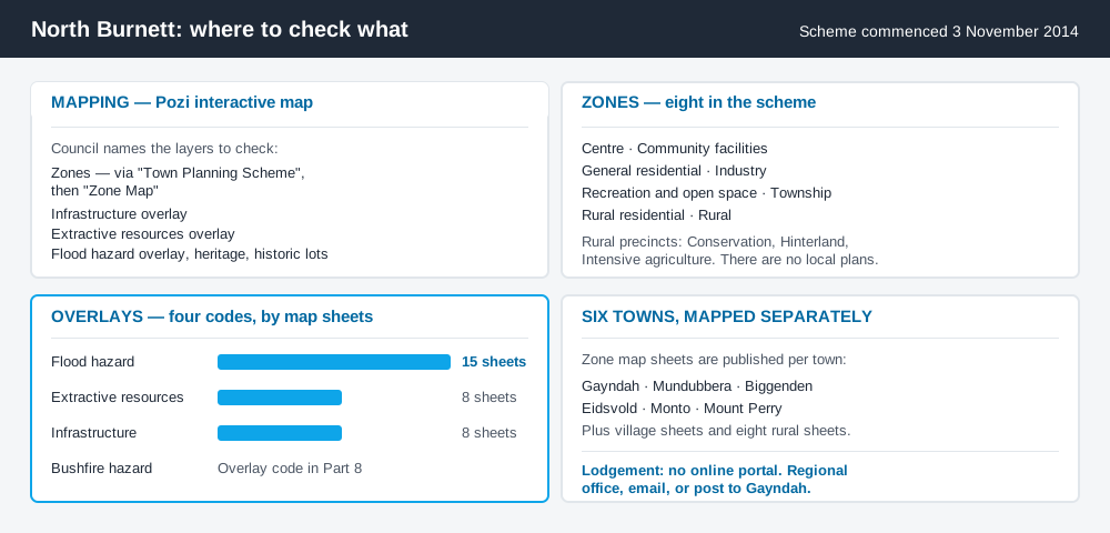
Figure 2: What North Burnett publishes, and what each source is actually for.
Council runs its interactive mapping on Pozi, linked from its Online Mapping page. Council's own guidance names the layers worth checking: zones, reached through "Town Planning Scheme" then "Zone Map"; the infrastructure, extractive resources and flood hazard overlays; the heritage register; and historic lots.
Council also publishes the scheme's map sheets as PDFs, organised by town — Monto, Mount Perry, Eidsvold, Mundubbera, Gayndah and Biggenden each get their own, with further sheets for the villages and eight covering the rural balance. For state layers, cross-check the site on the Queensland Globe.
What catches North Burnett owners out
Flood on productive land. The best growing country and the worst flood exposure are the same river flats. Packing sheds, cold rooms, farm-stay cabins and worker accommodation are routinely proposed there, and the flood hazard overlay can move work from accepted to assessable.
Assuming rural means unregulated. Reconfiguring a lot, operational works such as earthworks, and extractive industry all engage the scheme regardless of holding size, and minimum lot sizes still apply. Building on rural land and farm stay and agritourism cover the common cases.
A scheme mid-change. Council has consulted on a Business Resilience Amendment that would allow more business, community and industrial uses without a full application, add a renewable energy facility code, and permit small-scale ecotourism and agritourism in the Rural zone. Consultation has closed. Protections for Class A and Class B agricultural land and minimum lot sizes are not proposed to change. Check which version applies before relying on an older reading.
When you will probably need a DA
Work that starts a new use, materially increases the intensity of an existing one, subdivides or realigns boundaries, moves earth, or sits on the flood hazard overlay is likely to be assessable. Tourism and accommodation uses are live across all six towns. Modest work on an unconstrained town lot is far more often accepted development, subject to the requirements attached.
What to do next
Get the zone and precinct from Pozi, check the flood hazard overlay for the same address, then read the table of assessment for what you intend to do.
If you'd rather see the zone, the mapped constraints and the likely category of assessment for a North Burnett address in one place, an instantDA planning report does that for $169 — against the $800–$1,500 a town planner typically charges for a preliminary opinion. You can start a report in a few minutes.
Then talk to Council. There is no online portal here: the guidance is to discuss the proposal first, then lodge at any regional office, by email, or by post to Gayndah. Council's Planning and Development page has the scheme, the mapping and the fact sheets.
Frequently asked questions
What is North Burnett's planning scheme?
How do I lodge a development application in North Burnett?
How much does a development application cost in North Burnett?
What overlays apply in North Burnett?
Does the North Burnett scheme have local plans for each town?
Ready to generate your report?
Skip the writing. Get a council-ready planning report in 5 minutes.
Get your report