Key takeaways
- ✓Quilpie runs the Quilpie Shire Planning Scheme 2018, adopted 13 April 2018 and in effect from that date.
- ✓There are four zones only — Recreation and open space, Rural, Rural residential and Township.
- ✓The Township zone carries five precincts, including a Bulloo Park precinct and an Eromanga Natural History Museum precinct.
- ✓The scheme has no overlay codes. Flood comes from its own Schedule 2 mapping, bushfire from state mapping.
- ✓Applications go straight to Council at 50 Brolga Street, Quilpie — there is no online lodgement portal.
Do You Need Council Approval in Quilpie Shire?
You'll usually hear this called a development application, or DA — that's the formal name for council approval under the Planning Act 2016. In Quilpie Shire, Council is the assessment manager, and the rules it applies come from the Quilpie Shire Planning Scheme 2018.
Council's strategic framework builds the shire's future on cattle and sheep, the oil and gas of the Eromanga Basin, boulder opal, and palaeontology. In this guide: how the scheme is structured, the two approval tracks, how to check an address, and what catches Quilpie owners out.
Get a council-ready planning report in 5 minutes — no planner, no waiting.
Get your report →The short answer
In Quilpie Shire you need a development application when the Quilpie Shire Planning Scheme 2018 makes the work assessable for your zone. Plenty of modest work in town is accepted development. Building approval is a separate approval under the Building Act, and it catches things the planning scheme does not.
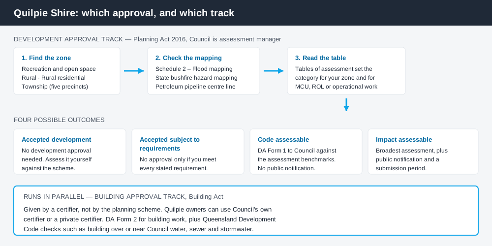
Figure 1: Two tracks run side by side. Clearing one does not clear the other.
The Quilpie Shire Planning Scheme 2018
Council adopted the scheme on 13 April 2018 and it has had effect from that date, replacing the Quilpie Shire Planning Scheme 2006, still published for tracing old approvals.
Queensland schemes follow a common structure — strategic framework, tables of assessment, zones, codes — but content is written council by council, so never assume a rule from another shire carries over. Quilpie's scheme is small: four zones — Recreation and open space, Rural, Rural residential, Township. Most of the shire is Rural; almost everything with a street address is Township.
Where Quilpie differs is the Township zone's five precincts: Commercial, Industrial, Residential, Bulloo Park, and an Eromanga Natural History Museum precinct. A dinosaur museum with its own statutory precinct is unusual anywhere in Queensland. What zone your property is in covers reading the zone map.
No overlay codes — so where do the constraints sit?
Spend 5 minutes, not 3 weeks
instantDA generates a council-ready planning report for Queensland development applications. No town planner. No waiting.
Get your report →The scheme has no overlay codes, which surprises people expecting a flood overlay and a bushfire overlay to look at. The tables of assessment point straight at maps instead.
Flood runs through the scheme's own Schedule 2 – Flood mapping. One condition recurs through the tables: a use is accepted development only where it is not located in a flood hazard area on that mapping. The strategic framework is blunt about the risk — Eromanga and Adavale have borne the brunt of events, while Council records that Quilpie town itself has not flooded and needs no levees. The mapping governs. Flood hazard overlays explains how these layers behave.
Bushfire works differently: the scheme sends you to state planning policy mapping rather than a council layer, and the tables adopt that state bushfire hazard mapping directly. Bushfire hazard overlays is the companion read.
A third layer is easy to miss: a petroleum pipeline is identified on the strategic framework mapping, and development near its centre line is regulated.
Two approval tracks, not one
Development approval is a Planning Act 2016 decision made by Council as assessment manager. It deals with land use, siting, scale and compliance with the scheme's codes.
Building approval is a Building Act decision about whether the structure complies, given by a building certifier. Quilpie is one of the shires where Council operates its own certifier alongside private ones, so you have a genuine choice — and the paperwork differs by which you pick. Building approval versus development approval covers the distinction.
Shipping containers illustrate it. Council treats a container as a Class 10a shed. Leave one on Township-zoned land at Quilpie, Eromanga, Adavale, Toompine or Cheepie for more than 30 days and you need building approval on DA Form 2, with a site plan and engineered footing details. Where Council water, sewer or stormwater runs nearby, the Queensland Development Code provisions on building near infrastructure bite too. Shipping containers is a common query here.
- ✓Which of the four zones?
- ✓Township precinct, if any?
- ✓Flood hazard on Schedule 2 mapping?
- ✓Bushfire on state mapping?
- ✓Near the petroleum pipeline?
- ✓Building approval as well?
Checking your own address
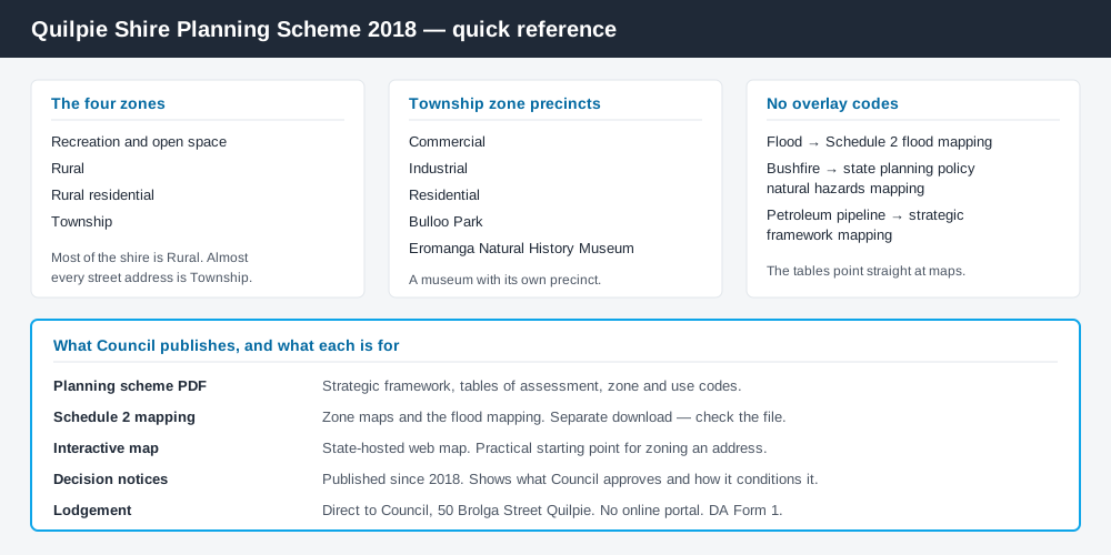
Figure 2: What Quilpie publishes, and what each source is actually for.
Quilpie does not run an ePlan platform. Council's Building & Planning page gives you an interactive map hosted as a state ArcGIS web application, the scheme as a PDF, and Schedule 2 mapping as a separate download. Watch the file names — the scheme and mapping downloads are not named as you would expect, so open each before relying on it.
Council also publishes decision notices on the same page, back to 2018: a child care centre, a transport depot for aircraft storage, cold storage for wild game, an artesian bore, museum extensions, reconfiguring a lot on Quilpie streets. Ten minutes there shows what Council actually approves. Cross-check state layers on the Queensland Globe.
What catches Quilpie owners out
Assuming rural means unregulated. Almost the whole shire is one Rural zone, easily read as a blank cheque. Reconfiguring a lot, operational work such as earthworks or clearing, and extractive industry all engage the scheme. Building on rural land sets out where the lines fall.
Workforce accommodation. The scheme steers non-resident workforce accommodation camps toward Quilpie town, in the Rural zone or Industrial precinct, and states plainly that no new mining towns will be established. A dedicated code applies.
Heritage and old workings. Schedule 6 is a local heritage register listing places you would not guess — the Cheepie railway complex, homestead ruins on Kyabra Creek, historic opal workings in the Canaway Range near Eromanga.
Encouragement is not exemption. Council runs a New Home Owner Grant policy encouraging new dwellings in the townships. A new dwelling still runs the normal process.
When you will probably need a DA
Work that starts a new use, materially increases the intensity of an existing one, subdivides or realigns boundaries, alters the shape of the land, or sits in mapped flood hazard is likely assessable. Tourism is live here — short-term accommodation and tourist parks have both been through the register. Modest work on an unconstrained township lot is more often accepted development, subject to requirements.
What to do next
Get the zone and any Township precinct from the interactive map, check Schedule 2 flood mapping for the same address, then read the table of assessment.
To see the zone, mapped constraints and likely category of assessment for a Quilpie address in one place, an instantDA planning report does that for $169 — against the $800–$1,500 a town planner typically charges for a preliminary opinion. Start a report in a few minutes.
Then talk to Council. Quilpie encourages a pre-lodgement meeting before you commit. Lodgement goes directly to Council — DA Form 1, landowner's consent, plans, a written report addressing the relevant code criteria, and the fee. Council's Building & Planning page has the scheme, mapping, fact sheets and decision notices.
Frequently asked questions
What is Quilpie Shire's planning scheme?
How do I lodge a development application in Quilpie Shire?
Does Quilpie have planning overlays?
How much does a development application cost in Quilpie Shire?
Do I need approval for a shipping container in Quilpie?
Ready to generate your report?
Skip the writing. Get a council-ready planning report in 5 minutes.
Get your report