Key takeaways
- ✓The scheme is the South Burnett Regional Council Planning Scheme 2017, Version 2.0, effective from 28 October 2024.
- ✓There are 16 zones, including a Winery precinct in the Rural zone at Moffatdale and Bunya Mountains precincts.
- ✓Eleven overlays are mapped, but only the bushfire hazard overlay has its own overlay code — the other ten are assessed through the zone codes.
- ✓Land on the historic subdivisions and extractive resources overlay maps changes how a dwelling house is categorised.
- ✓Council does not run an online lodgement portal; applications go to Council directly.
Do You Need Council Approval in South Burnett?
You'll usually hear this called a development application, or DA — that's the formal name for council approval under the Planning Act 2016. In the South Burnett, Council is the assessment manager and the rules come from the South Burnett Regional Council Planning Scheme 2017, now at Version 2.0.
The region runs from Blackbutt and Nanango through Kingaroy, Wondai, Murgon and Proston, with the Bunya Mountains on its western edge and Tarong Power Station in the south-east. Kingaroy is the peanut capital, but the scheme also protects a wine district, dam catchments and a lot of good agricultural country.
In this guide: how the scheme is built, the two approval tracks, how to check an address, and what catches owners out.
Get a council-ready planning report in 5 minutes — no planner, no waiting.
Get your report →The short answer
You need a development application when the South Burnett Regional Council Planning Scheme 2017 makes your proposal assessable in your zone, or an overlay changes the category. Plenty of minor domestic work in town is accepted development. Building approval is separate, and usually comes from a private certifier.
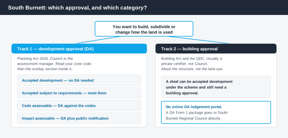
Figure 1: Two tracks run in parallel. One answer does not settle the other.
The South Burnett Regional Council Planning Scheme 2017
The scheme may be cited simply as the South Burnett Regional Council Planning Scheme. It first commenced on 2 October 2017, and Major Amendment No. 1 is carried into Version 2.0, effective from 28 October 2024 — the version to read.
It follows the standard Queensland structure — strategic framework, tables of assessment, zone codes, overlays, development codes — but the content is local. There are 16 zones, and several carry precincts that do real work: a Winery precinct in the Rural zone at Moffatdale, a Bunya Mountains precinct in the Low density residential and the Environmental management and conservation zones, and a 4,000m² precinct in the Rural residential zone. Queensland schemes share a structure, not their content. Working out what zone you are in is step one.
Eleven overlays, one overlay code
Spend 5 minutes, not 3 weeks
instantDA generates a council-ready planning report for Queensland development applications. No town planner. No waiting.
Get your report →This is the most distinctive feature of the scheme. It maps eleven overlays: agricultural land, airport environs, biodiversity, bushfire hazard, extractive resources, flood hazard, historic subdivisions, landslide hazard, regional infrastructure, sensitive uses separation, and water catchments. Water catchments splits again into a water resource catchment sub-area and a dam buffer sub-area — that is what the Boondooma and Bjelke-Petersen storages sit behind.
But Part 7 contains a code for only one: bushfire hazard. For the other ten, the benchmarks sit in a numbered section of the relevant zone code — Rural zone code Section 10, Township zone code Section 10, Low density residential zone code Section 7 — plus the reconfiguring a lot and services and works codes. Go looking for an "agricultural land overlay code" and you will not find one, then wrongly conclude it does nothing.
- ✓Which zone?
- ✓Any precinct?
- ✓Which overlays?
- ✓Which zone code section carries them?
- ✓Accepted, or assessable?
- ✓Building approval too?
Two approval tracks, not one
Development approval is the Planning Act 2016 decision, made by Council as assessment manager. It is about land use, siting, lot size, intensity and the scheme's assessment benchmarks.
Building approval is a Building Act decision about whether the structure complies with the building assessment provisions and the QDC, usually given by a private certifier rather than Council. A shed can be accepted development under the scheme and still need a building approval — the difference between the two is the most common misunderstanding we see.
Council does not publish an online DA lodgement portal, so a DA Form 1 package goes to Council directly.
Checking your own address
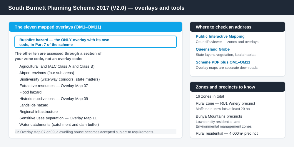
Figure 2: What Council publishes, and what each source is for.
Council's Online Maps page is the starting point. It carries Public Interactive Mapping, Council's own viewer, plus links to the State Planning Policy mapping and the Queensland Globe — use the Council viewer for zone and overlay layers, the Globe for state layers such as vegetation and koala habitat.
Then read the documents. Council publishes Version 2.0 as a single PDF, with eleven separate overlay maps, OM1 through OM11, as their own downloads. Getting the overlay picture right means opening more than one file. How to check overlays covers the method.
What catches South Burnett owners out
Historic subdivisions. Parts of the region were cut into small lots a century ago, at Blackbutt, Proston, Cloyna, Mondure, Memerambi, Crawford and Coolabunia. The scheme directs residential development away from them. Its benchmarks ask whether the site is within 5 km by road of a school if it is not on a school bus route, and whether it fronts a gazetted and constructed road — Council's Construction of Unmade Roads policy decides that. A cheap old lot can carry a large road bill.
The dwelling house switch. Land shown on Overlay Map 07 (extractive resources) or Overlay Map 09 (historic subdivisions) shifts a material change of use for a dwelling house to accepted subject to requirements — a real category, not the same as plain accepted development. Meet the stated requirements, or you need a DA.
Agricultural land and buffers. The agricultural land overlay maps Agricultural Land Classification Class A and Class B, and the strategy resists rural residential expansion that would cost good quality agricultural land. The sensitive uses separation overlay, Overlay Map 11, protects the buffer around the Swickers Kingaroy Bacon Factory. Building on rural land covers this ground.
The Winery precinct. In the RU1 Winery precinct around Moffatdale, reconfiguring a lot is expected to leave lots of at least 20 hectares, to keep viticulture, boutique food and tourism viable. Reconfiguring a lot explains the process.
When you will probably need a DA
Starting a new use, intensifying an existing one, subdividing or realigning boundaries, and most earthworks above the scheme's thresholds are likely to be assessable. Rural tourism, cellar doors, farm stays and short-term accommodation are material changes of use even on land already farmed. Bushfire is a live constraint across much of the region, and it is the one overlay with its own code — bushfire hazard overlays explains those benchmarks.
What to do next
Get the zone and precinct from Public Interactive Mapping, list every overlay touching the site, then read the matching section of your zone code rather than hunting for an overlay code that does not exist.
If you would rather see the zone, the mapped constraints and the likely category of assessment for a South Burnett address in one place, an instantDA planning report covers it for $169 — against the $800–$1,500 a town planner typically charges for a preliminary opinion. You can start a report in a few minutes.
Then talk to Council's planning team. Several items in the register of fees and charges are priced on application, so confirm your figure first. Council's Planning and Development pages hold the scheme, the overlay maps and the forms.
Frequently asked questions
What planning scheme applies in the South Burnett?
How many overlays does the South Burnett scheme have?
How much does a development application cost in the South Burnett?
Where do I check the zoning of a South Burnett property?
Ready to generate your report?
Skip the writing. Get a council-ready planning report in 5 minutes.
Get your report