Key takeaways
- ✓One consolidated scheme covers the whole region: the Southern Downs Planning Scheme, Version 5, effective 29 June 2018.
- ✓There are no separate Warwick and Stanthorpe schemes still running — the old shire schemes are historic only.
- ✓Online Mapping is Council's tool for checking zone and overlays; eSubmit is where new applications are lodged.
- ✓Bushfire, flood, heritage and the water resource catchments overlay are the layers that bite hardest here.
- ✓Rural land classified ALC Class A or Class B is given strong protection in the Rural zone code.
Do You Need Council Approval in Southern Downs?
You'll usually hear this called a development application, or DA — that's the formal name for council approval under the Planning Act 2016. In the Southern Downs, Council is the assessment manager for most of them, and the rules it applies come from the Southern Downs Planning Scheme.
Worth clearing up first, because locals often ask: Council was formed from the former Warwick and Stanthorpe shires, and those areas once had their own schemes. They no longer do. One consolidated scheme covers the whole region, from Warwick and Killarney down through Stanthorpe, Ballandean and Wallangarra.
Get a council-ready planning report in 5 minutes — no planner, no waiting.
Get your report →The short answer
You need a development application when the Southern Downs Planning Scheme makes your work assessable for its zone and overlays. Much minor domestic work is accepted development. Building approval is a separate process, usually handled by a private certifier rather than Council.
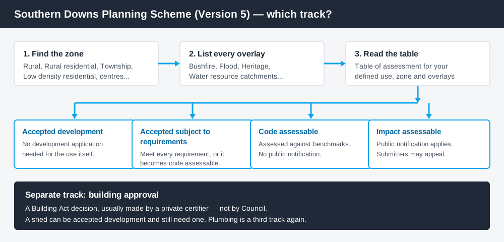
Figure 1: Two tracks run side by side. Clearing one does not clear the other.
The Southern Downs Planning Scheme
The scheme commenced on 14 August 2012, and the current version is Version 5, adopted 27 June 2018 and effective 29 June 2018. Earlier versions — 3, 3.1 and 4.1 — are published as superseded schemes, a useful cross-check if you are dealing with an older approval.
Council has been running a review and preparing a replacement scheme. Until that commences, Version 5 is operative, and it is what your application is assessed against.
Like every Queensland scheme, Southern Downs follows the standard state structure — a strategic framework, zone codes, overlay codes and tables of assessment — with local codes layered on top. Queensland schemes are not uniform, so a rule you read for another council will not transfer. The zones here include Rural, Rural residential, Township, Low and Medium density residential, District centre, Principal centre, Specialised centre, Mixed use, Industry, Community facilities, Environmental management and conservation, and Limited development (constrained land). How to find out what zone your property is in covers reading that structure.
Two approval tracks, not one
Spend 5 minutes, not 3 weeks
instantDA generates a council-ready planning report for Queensland development applications. No town planner. No waiting.
Get your report →Development approval is a Planning Act 2016 decision, with Council as assessment manager. It deals with land use, siting, scale and compliance with the codes in the scheme.
Building approval is a Building Act decision about whether the structure itself complies. It is usually given by a private certifier, not by Council.
Different legislation, different decision-makers. A farm shed can be accepted development under the scheme and still need building approval, and holding a building approval does not cure a missing development approval. Building approval versus development approval covers the distinction properly.
- ✓What zone is the land in?
- ✓Which overlays touch it?
- ✓Is the work accepted, or assessable?
- ✓If accepted, is it accepted subject to requirements?
- ✓Do you also need building approval?
- ✓Is there plumbing or on-site wastewater involved?
Checking your own address
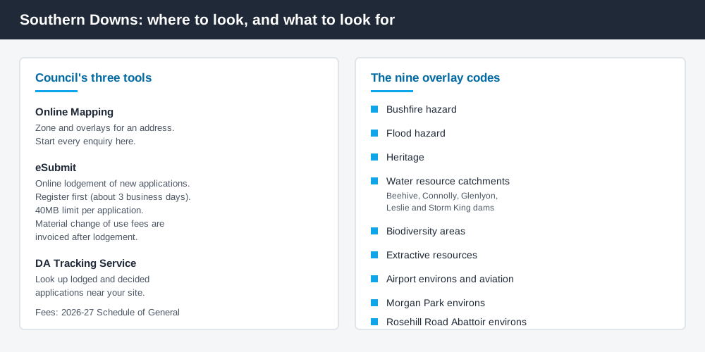
Figure 2: Council's tools, and the overlays that most often change the answer.
Council's Online Mapping service is the starting point for zone and overlay information. Alongside it, the Development Application Tracking Service lets you look up applications already lodged, which is the fastest way to learn what Council has actually accepted on comparable land near you.
New applications go through eSubmit, Council's online lodgement service, run jointly with the Queensland Government. Two practical notes. Registration is finalised within about three business days before you can lodge, and Council can only receive an application up to 40MB, so large plan sets need compressing or splitting. For a material change of use, fees are not paid online — a Council officer contacts you after lodgement.
For state layers such as vegetation mapping, cross-check the site on the Queensland Globe.
What catches Southern Downs owners out
Agricultural land. The Rural zone code protects land classified Agricultural Land Classification Class A or Class B from alienation and diminished productivity, and says this protection takes precedence over other development interests except in exceptional circumstances. That is unusually firm language, and it shapes what is realistic on cropping and horticultural country. Building on rural land covers the pattern.
Bushfire. The Bushfire hazard overlay code reaches across much of the granite country and the ranges, and Council publishes a practice note on how it reads that code for lower-risk development. The bushfire hazard overlay explained sets out what assessment involves.
Water catchments. The Water resource catchments overlay names Beehive, Connolly, Glenlyon, Leslie and Storm King dams, and its acceptable outcomes keep development back from the full supply level and from waterways in the overlay. Water security is not abstract here: Stanthorpe's town water was carted by road from Connolly Dam to Storm King Dam from January 2020 until March 2021.
Heritage. Warwick's sandstone civic and church buildings define the streetscape, and Council maintains a local heritage register as well as applying the Heritage overlay code. The heritage overlay explained covers what listing means in practice.
Tourism on rural land. Cellar doors, farm gate sales and short-term accommodation across the Granite Belt are land uses in their own right. A winery, for instance, is a tourist use in Council's fee schedule. Farm stays and agritourism is the relevant background.
When you will probably need a DA
The pattern is reasonably consistent. Work that changes the use of land, adds a dwelling, subdivides, sits within a hazard or catchment overlay, touches a heritage place, or exceeds a code threshold is likely to be assessable. Modest domestic work on an unconstrained lot in town is more often accepted development, subject to any requirements attached. The reliable answer comes from the table of assessment for your defined use.
What to do next
Check the address on Online Mapping, write down the zone and every overlay, then read the table of assessment for what you intend to do. Council's Fees and Charges page carries the current schedule; figures reset each financial year, so always take them from the current document.
If you would rather have the zone, the overlays and the likely category of assessment for a Southern Downs address pulled together in one place, an instantDA planning report does that for $169 — against the $800–$1,500 a town planner typically charges for a preliminary opinion. You can start a report in a few minutes.
Then confirm with Council before you commission drawings, particularly on Class A or Class B agricultural land, in a catchment, or near a heritage place.
Frequently asked questions
Does Southern Downs still use separate Warwick and Stanthorpe planning schemes?
What version of the Southern Downs Planning Scheme is current?
How do I check the zoning of a Southern Downs property?
How do I lodge a development application with Southern Downs Regional Council?
Is building approval the same as council approval here?
Ready to generate your report?
Skip the writing. Get a council-ready planning report in 5 minutes.
Get your report